
Tieschen
|
market community Tieschen
|
||
|---|---|---|
| coat of arms | Austria map | |
 |
|
|
| Basic data | ||
| Country: | Austria | |
| State : | Styria | |
| Political District : | Southeast Styria | |
| License plate : | SO (from 1.7.2013; old: RA) | |
| Surface: | 18.17 km² | |
| Coordinates : | 46 ° 47 ' N , 15 ° 57' E | |
| Height : | 260 m above sea level A. | |
| Residents : | 1,222 (January 1, 2020) | |
| Postal code : | 8355 | |
| Area code : | 03475 | |
| Community code : | 6 23 68 | |
| NUTS region | AT224 | |
| Address of the municipal administration: |
Tieschen 55 8355 Tieschen |
|
| Website: | ||
| politics | ||
| Mayor : | Martin Weber ( SPÖ ) | |
|
Municipal Council : (2020) (15 members) |
||
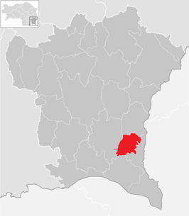
| Location of Tieschen in the district of Southeast Styria | ||
  |
||
 Tieschen parish church |
||
| Source: Municipal data from Statistics Austria | ||


Tieschen is a market town with 1,222 inhabitants (as of January 1, 2020) in the south-east of Styria . It lies in the judicial district of Feldbach or the district of Southeast Styria .
geography
Tieschen is located in the district of Südoststeiermark in the Austrian state of Styria .
Community structure
The community consists of six cadastral communities and is divided into just as many towns of the same name (population in brackets as of January 1, 2020):
- Großering (173.33 ha; 128 Ew.) Including Alla and Auberg
- Jörgen (313.84 ha; 154 Ew.) Including Dirneck, Eselberg, Reichel and Süßegg
- Laasen (356.13 ha; 193 Ew.) Including Haderberg, Oberlaasen, Preguckenberg, Strändl and Unterlaasen
- Patzen (169.26 ha; 188 Ew.) Including Patzenberg and Tratten
- Pichla near Radkersburg (584.80 ha; 254 Ew.) Including Auberg, Globitsch, Kerschenberg and Mitschok
- Tieschen (209.16 ha; 305 Ew.) Including Hochstrandler, Königsberg, Pum and SET
Neighboring communities
| Sankt Anna am Aigen | ||
| Straden |
.svg)
|
Kloch |
| Halfway |
history
Tieschen was first mentioned in a document in 1406 in the tithe book of the diocese of Seckau. This written certificate is identical to the current writing. The name goes back to the Slavic personal name Tĕšina or similar. Since the end of the 15th century, the parish Fehring was landlord in "Türschen". The abolition of the manorial lords took place in 1848. The local community Tieschen was established as an autonomous body in 1850. After the annexation of Austria in 1938, the community came to Reichsgau Styria, from 1945 to 1955 it was part of the British zone of occupation in Austria.
Foundation of the large community of Tieschen
The large community of Tieschen was founded on January 1st, 1951. By ordinance of the Styrian state government of December 27, 1950, the previously independent municipalities were made
- Großering (under Mayor Franz Benedikt),
- Jörgen (under Mayor Richard Edelsbrunner),
- Laasen (under Mayor Ignaz Maier),
- Patzen (under Mayor Richard Stradner) and
- Pichla near Radkersburg (under Mayor Franz Puff) with the community
- Tieschen (under Mayor Edwin Kolleritsch) united to form Tieschen.
After the merger took place, the district captain of Radkersburg Max Schistl was first appointed as government commissioner . It was not until December 7, 1951 that Franz Puff was elected the first mayor of the new municipality. According to the census of June 1, 1951, the population was 1,541 residents in 345 houses. The municipal area was 18.08 square kilometers.
Ramparts on the Königsberg

In the area of the volcanic massif near Klöch north of Radkersburg, the highest point is the 459 m high Königsberg in the municipality of Tieschen. It dominates the Steintal and was fortified with a rampart early on because of its steep flanks. When Chunigesberg was first mentioned in 1406, the remains of the complex have been known since 1822. From 1840 excavations took place, which were continued in 1886 and 1897, the results of which have however been lost. In 1899, in a recording by the Joanneum in Graz, the complex was referred to as the “sunken city on the Königsberg” and considered a Celtic-Roman fortress. From 1924 to 1962 the excavations were followed up by local homeland researchers. Most of the finds can no longer be found, there have also been robbery excavations and private probe users . The first excavations by the Joanneum were carried out in 1928, floor plans of houses were uncovered both in the process and in 1934. The reports on the finds are imprecise and imaginative, so there are reports of "Sanctuaries of the Eastern Norse culture with sacrificial pits".
During the fighting of the Second World War , Wehrmacht troops occupied the ramparts and defended them against the Red Army . The search for those killed in war also brought to light other archaeological objects. These finds of remains of dry stone walls , building foundation walls and individual objects prove that the ramparts were densely populated.
Settlement can be chronological from the 4th millennium BC. Be accepted. After a settlement interruption in the Bronze Age, there are again finds from the Urnfield culture , the entire Hallstatt and Latène Ages . An area of around 10 hectares was settled and solidly fortified, the remnants of which are ramparts and moats on the east and south sides, as well as a gate system with a rampart. At the highest point of the mountain on the northeast corner is the core piece, which was specially enclosed with a dry stone wall. Ceramics and stone utensils belonging to the Lasinja culture , a gold coin found in 1901, several small finds and a coin of Constantius II have been recovered. The classification of the finds confirms the heyday of the settlement in the Urnfield period, a decline during the Latène period and a continuation assumed from the old records in the provincial Roman period. The ramparts were used as a place of refuge several times during the Turkish and Kuruzar Wars.
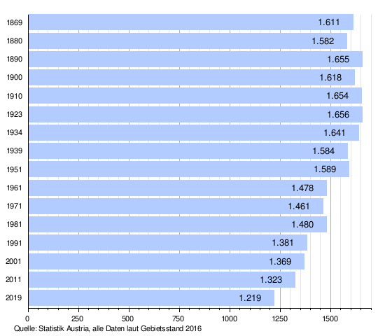
Population development
Culture and sights

- Parish church hl. Trinity
- The natural monument Basaltspalte von Tieschen is a rock crevice with forced rock melt.
politics
mayor
Martin Weber has been the mayor since April 2000 .
The community board also includes Vice Mayor Richard Haas and community treasurer Anton Koller.
Mayor since 1951
Tieschen has had the following mayors since 1951:
- 1951–1968 Franz Puff
- 1968–1970 Edwin Kolleritsch
- 1970–1985 Leopold Tschiggerl
- 1985-2000 Karl Pachler
- 2000 - Martin Weber
Municipal council

The municipal council consists of 15 members and will be composed as follows after the 2020 municipal council elections :
The last municipal council elections brought the following results:
| Political party | 2020 | 2015 | 2010 | 2005 | 2000 | ||||||||||
|---|---|---|---|---|---|---|---|---|---|---|---|---|---|---|---|
| St. | % | M. | St. | % | M. | St. | % | M. | St. | % | M. | St. | % | M. | |
| SPÖ | 11 | 568 | 59 | 9 | 648 | 61 | 10 | 704 | 66 | 10 | 357 | 40 | 6th | ||
| ÖVP | 4th | 403 | 41 | 6th | 377 | 36 | 5 | 330 | 31 | 5 | 462 | 51 | 8th | ||
| FPÖ | not running | not running | 32 | 3 | 0 | 83 | 9 | 1 | |||||||
| The green | not running | 31 | 3 | 0 | not running | not running | |||||||||
| Eligible voters | 1,120 | 1,175 | 1,184 | 1,098 | |||||||||||
| voter turnout | 89% | 91% | 91% | 84% | |||||||||||
Personalities
Honorary citizen
- 1966: Franz Wegart (1918–2009), Provincial Councilor
- 1984: Josef Krainer (1930–2016), Governor of Styria 1980–1996
literature
- Christa Schillinger-Prassl (ed.): Tieschen local history. From the hilltop settlement to the market square. Tieschen 1998
Web links
- 62368 - Tieschen. Community data, Statistics Austria .
- tieschen.gv.at/marktgemeinde Website of the market municipality
- History about Tieschen. Tieschen municipal office, accessed on December 28, 2011 .
- Archeology in Vulkanland Prehistoric hilltop settlement on the Königsberg, accessed on June 9, 2013
Individual evidence
- ↑ Statistics Austria: Population on January 1st, 2020 by locality (area status on January 1st, 2020) , ( CSV )
- ↑ Fritz Frhr. Lochner von Hüttenbach: On the name property of the early Middle Ages in Styria (= magazine of the Historical Association for Styria . Volume 99 ). Böhlau Verlag, Vienna 2008, p. 48 ( historerverein-stmk.at [PDF; 16.9 MB ]).
- ↑ State Law Gazette 65/1950
- ^ Franz-Josef Schober in "Ortsgeschichte Tischen", ed. Marktgemeinde Tieschen, 1998, p. 147 f
- ↑ Susanne Sievers / Otto Helmut Urban / Peter C. Ramsl: “Lexicon for Celtic Archeology. A – K and L – Z ”; Announcements of the prehistoric commission in the publishing house of the Austrian Academy of Sciences , Vienna 2012, ISBN 978-3-7001-6765-5 , p. 942 f.
- ↑ a b Municipality of Tieschen: The Mayor , accessed on May 11, 2015.
- ^ Community Tieschen: local council , accessed on May 11, 2015.
- ↑ Südost-Tagespost on July 12, 1966, p. 6.
- ↑ Südost-Tagespost on May 29, 1984, p. 6.

Bad Gleichenberg |
Bad Radkersburg |
German Goritz |
Edelsbach near Feldbach |
Eichkögl |
Fehring |
Feldbach |
Gnas |
Halbenrain |
Jagerberg |
Kapfenstein |
Kirchbach-Zerlach |
Kirchberg an der Raab |
Kloch |
Mettersdorf am Saßbach |
Mureck |
Paldau |
Pirching am Traubenberg |
Riegersburg |
Sankt Anna am Aigen |
Sankt Peter am Ottersbach |
Sankt Stefan im Rosental |
Straden |
Tieschen |
Unterlamm
61 communities in the former Feldbach district were dissolved between 1945 and 1969. Altenmarkt bei Riegersburg |
Aschau am Ottersbach |
Axbach |
Dirnbach |
Erbersdorf |
Fischa |
Frutten |
Geisselsdorf |
Gleichenberg village |
Gniebing |
Grasdorf |
Grub II |
Gutendorf |
Hague |
Habegg |
Hainsdorf-Brunnsee |
Carrying up |
Höflach |
Hohenbrugg an der Raab |
Jamm |
Kaag |
Karbach |
Clapping |
Koelldorf |
Krennach |
Krottendorf im Sassal |
Lembach near Riegersburg |
Lichtenegg |
Lugitsch |
Maggau # |
Magland |
Mahrensdorf |
Mitterfladnitz |
Muggendorf |
Neustift |
Obergnas |
Oberlamm |
Oberrakitsch |
Oedt near Feldbach |
Petersdorf I |
Petzelsdorf near Fehring |
Plesch |
Rettenbach in East Styria |
Risola |
Rohr an der Raab |
Saaz |
Scheinz |
Slate |
Stang near Hatzendorf |
Sulzbach |
Trössengraben |
Ungerdorf |
Unterlabill # |
Waldsberg |
Waltra |
Weinberg an der Raab |
Weißenbach near Feldbach |
Wetzelsdorf near Kirchbach |
Wilhelmsdorf |
Wörth near Kirchberg an der Raab |
Ziprein 59 communities of the former Radkersburg district were dissolved between 1945 and 1969 Altneudörfl |
Dedenitz |
German Haseldorf |
Diepersdorf |
Dietzen |
Donnersdorf |
Dornau |
On top |
Edla |
Deinendorf am Ottersbach |
Goritz near Radkersburg |
Greater |
Gruisla |
Hard at Straden |
Farmsteads near Deutsch Goritz |
Hummersdorf |
Huerth |
Jörgen |
Karla |
Krobaths |
Kronnersdorf |
Laafeld |
Laasen |
Landorf |
Lichendorf # |
Marktl |
Nägelsdorf |
New set |
Oberpurkla |
Oberschwarza # |
Patzen |
Perbersdorf near Sankt Peter |
Perbersdorf near Sankt Veit # |
Parish village |
Pichla at Mureck # |
Pichla near Radkersburg |
Pölten |
Pridahof |
Radishes |
Rannersdorf am Saßbach |
Rohrbach am Rosenberg |
Salsach |
Schrötten near Deutsch Goritz |
Schwabau |
Seibersdorf near Sankt Veit # |
Sicheldorf |
Siebing # |
Spitz at Deutsch Goritz |
Unterpurkla |
Unterschwarza # |
Waasen am Berg |
Weitersfeld on the Mur # |
Weixelbaum |
Wieden-Klausen |
Wiersdorf |
Wittmannsdorf |
Zehensdorf |
Zelting 50 communities in the district of Southeast Styria were dissolved between 2015 and 2020 Auersbach |
Aug-Radisch |
Bavarian Kölldorf |
Baumgarten near Gnas |
Bierbaum am Auersbach |
Breitenfeld on the Rittschein |
Dietersdorf am Gnasbach |
Precious perennials |
Eichfeld |
Fladnitz im Raabtal |
Frannach |
Frutten-Gießelsdorf |
Glojach |
Gniebing-Weißenbach |
Gosdorf |
Gossendorf |
Grabersdorf |
Hatzendorf |
Hof bei Straden |
Hohenbrugg vineyard |
Johnsdorf-Brunn |
Kohlberg |
Kornberg near Riegersburg |
Krusdorf |
Leitersdorf im Raabtal |
Lödersdorf |
Maierdorf |
Merkendorf |
Mitterlabill # |
Mühldorf near Feldbach |
Murfeld # |
Oberdorf am Hochegg |
Oberstorcha |
Oberstorcha |
Perlsdorf |
Pertlstein |
Petersdorf II |
Poppendorf |
Raabau |
Radkersburg area |
Raning |
Ratschendorf |
Schwarzau in the Schwarzautal # |
Stainz near Straden |
Studenzen |
Trautmannsdorf in East Styria |
Trössing |
Unterauersbach |
Weinburg am Saßbach # |
Zerlach # former community was at the resolution District Leibnitz assigned