
Pierrafortscha
| Pierrafortscha | |
|---|---|
 |
|
| State : |
|
| Canton : |
|
| District : | Saane |
| BFS no. : | 2216 |
| Postal code : | 1723 |
| Coordinates : | 580 633 / 181784 |
| Height : | 751 m above sea level M. |
| Height range : | 553–783 m above sea level M. |
| Area : | 5.06 km² |
| Residents: | 156 (December 31, 2018) |
| Population density : | 31 inhabitants per km² |
| Website: | www.pierrafortscha.ch |
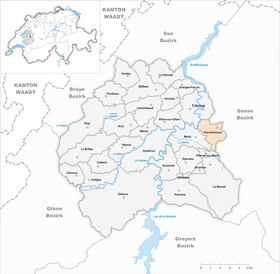
| Location of the municipality | |
  |
|
Pierrafortscha ( Freiburger Patois ) is a municipality in the District de la Sarine (German: Saanebezirk) in the canton of Friborg in Switzerland . Despite the location on the language border, the former German name Perfetschied is only rarely used today.
geography
Pierrafortscha lies at 751 m above sea level. M. , 3 km southeast of the canton capital Friborg (beeline). The scattered settlement extends in a promising location at the height east of the Saanegraben , in the Molasse hills of the Freiburg Central Plateau .
The area of the 5.1 km² municipal area comprises a section of the Molasse Heights between the Saane and the pre-alpine hill country. The central part of the area is made up of a gently undulating highland with the hills Chantemerle ( 756 m above sea level ), Pierrafortscha ( 758 m above sea level ), Le Croquelet ( 767 m above sea level ) and Bois de Morvin (with 782 m above sea level the highest point of Pierrafortscha). To the south, the community soil extends over a plateau to the river of the Ärgera (French: Gérine). The western border is formed by the Saane, which is dammed up here to Lake Pérolles , which is cut deep into the molasse history and has steep slopes criss-crossed by sandstone cliffs. In 1997, 7% of the municipal area was in settlements, 21% in forests and woodlands, 71% in agriculture and around 1% was unproductive land.
Pierrafortscha includes the hamlets of Granges-sur-Marly ( 704 m above sea level ) on the slope above Marly, Morvin ( 740 m above sea level ; German Helmetingen ) and Villars-sur-Marly ( 720 m above sea level). ) on the plateau south of the Bois de Morvin, Pfaffenwil ( 692 m above sea level ) on the plateau east of Marly and various individual farms. The neighboring communities of Pierrafortscha are Freiburg , Sankt Ursen , Tentlingen , Villarsel-sur-Marly and Marly .
population
With 156 inhabitants (as of December 31, 2018) Pierrafortscha is one of the smallest municipalities in the canton of Friborg. Of the residents, 70.6% are French-speaking, 27.9% German-speaking and 1.5% speak Italian (as of 2000). The population of Pierrafortscha was 185 in 1900. After a peak in 1930 with 260 inhabitants, a population decline of over 45% has been recorded since then due to continuous emigration.
economy
Pierrafortscha was a predominantly agricultural village until the second half of the 20th century . Even today, the have farming , the fruit production , the dairy industry and animal husbandry an important role in the employment structure of the population. Some other jobs are available in local small businesses and in the service sector. In the last few decades the village has also developed into a residential community thanks to its attractive location. Many of the employed people today are commuters who mainly work in the Freiburg region.
traffic
The municipality is located away from the major thoroughfares; the main access is from the Bourguillon district of the city of Freiburg . Pierrafortscha itself is not connected to the public transport network.
history

The place name Pierrafortscha describes the patois expression for pierre fourchue (forked stone) based on an erratic block on the Champ de la Pierre corridor. In the course of the 15th century Pierrafortscha came under the rule of Freiburg and was assigned to the old landscape (Burgpanner). After the collapse of the Ancien Régime (1798), the village belonged to the Friborg district during the Helvetic and the following period, before it was incorporated into the Saane district in 1848 with the new cantonal constitution.
Attractions
In the various hamlets of Pierrafortscha there are chapels and wayside crosses along the roads. Some characteristic peasant and patrician houses from the 18th and 19th centuries have been preserved.
Web links
- Official website of the municipality of Pierrafortscha (French)
- Marianne Rolle / BE: Pierrafortscha. In: Historical Lexicon of Switzerland .
Individual evidence
- ↑ Permanent and non-permanent resident population by year, canton, district, municipality, population type and gender (permanent resident population). In: bfs. admin.ch . Federal Statistical Office (FSO), August 31, 2019, accessed on December 22, 2019 .
Arconciel | Autigny | Avry | Belfaux | Chénens | Corminboeuf | Cottens | Ependes | Ferpicloz | Freiburg | Gibloux | Givisiez | Granges-Paccot | Grolley | Hauterive | La Brillaz | La Sonnaz | Le Mouret | Marly | Matran | Neyruz | Pierrafortscha | Ponthaux | Prez | Senèdes | Treyvaux | Villarsel-sur-Marly | Villars-sur-Glâne
Former parishes: Autafond | Avry-sur-Matran | Bonnefontaine | Chésalles | Chésopelloz | Cormagens | Corpataux | Corpataux-Magnedens | Corsalettes | Corserey | Corjolens | Cutterwil | Ecuvillens | Essert | Estavayer-le-Gibloux | Farvagny | Farvagny-le-Grand | Farvagny-le-Petit | Formangueires | Grenilles | Illens | La Corbaz | Le Glèbe | Lentigny | Lossy | Lossy Formangueires | Lovens | Magnedens | Marly-le-Grand | Marly-le-Petit | Montécu | Montévraz | Nierlet-les-Bois | Noréaz | Oberried | Onnens | Posat | Posieux | Prelude | Prez-vers-Noréaz | Rossens | Rueyres-Saint-Laurent | Sales | Villarlod | Villarsel-le-Gibloux | Vuisternens-en-Ogoz | Zénauva
Canton of Friborg | Districts of the canton of Friborg | Municipalities of the canton of Friborg