
Ilztal
|
Ilztal
|
||
|---|---|---|
| coat of arms | Austria map | |
 |
|
|
| Basic data | ||
| Country: | Austria | |
| State : | Styria | |
| Political District : | Wheat | |
| License plate : | WZ | |
| Main town : | Prebensdorf | |
| Surface: | 22.48 km² | |
| Coordinates : | 47 ° 8 ' N , 15 ° 47' E | |
| Height : | 330 m above sea level A. | |
| Residents : | 2,180 (January 1, 2020) | |
| Postal code : | 8211 | |
| Area code : | 03112, 03113, 03118 | |
| Community code : | 6 17 62 | |
| NUTS region | AT224 | |
| Address of the municipal administration: |
Prebensdorf 170 8211 Ilztal |
|
| Website: | ||
| politics | ||
| Mayor : | Andreas Nagl ( ÖVP ) | |
|
Municipal Council : (2020) (15 members) |
||
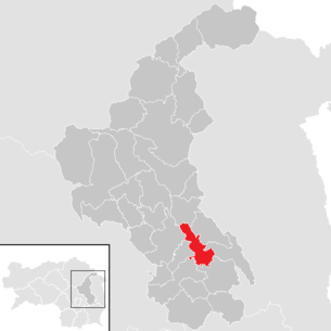
| Location of Ilztal in the Weiz district | ||
  |
||
| Source: Municipal data from Statistics Austria | ||

Ilztal is a municipality with 2180 inhabitants (as of January 1, 2020), it is located in the judicial district and district of Weiz in southeast Styria ( Austria ). As part of the municipal structural reform in Styria , it has been merged with the Preßguts municipality since 2015 ; the new municipality continues to use the name Ilztal. The basis for this is the Styrian Municipal Structural Reform Act - StGsrG.
geography
Geographical location
The municipality is located about 20 km east of Graz and 10 km southeast of the district capital Weiz in the Ilz valley in the eastern Styrian hill country .
Community structure
The municipality includes the following seven localities (residents as of January 1, 2020):
- Grosspesendorf (146)
- Neudorf (442)
- Nitschaberg (140)
- Prebensdorf (761)
- Material to be pressed (302)
- Schirnitz (87)
- Wolfgruben near Gleisdorf (302)
The community consists of six cadastral communities (area 2015):
- Großpesendorf (276.28 ha)
- Neudorf (370.40 ha)
- Nitschaberg (63.86 ha)
- Prebensdorf (729.77 ha)
- Preßguts (648.74 ha)
- Wolfsgruben near Gleisdorf (158.76 ha)
Neighboring communities
Seven municipalities border the Ilztal, all of them in the Weiz district. Clockwise are:
- in the north of Puch near Weiz
- in the northeast of Pischelsdorf
- in the east Gersdorf an der Feistritz
- in the southeast and south Sinabelkirchen
- in the southwest of Gleisdorf
- in the west Albersdorf-Prebuch
- in the northwest of Sankt Ruprecht an der Raab
history
There is evidence of a settlement as early as Roman times when the area belonged to the province of Pannonia .
The strokes of fate that afflicted the places over the centuries are particularly striking:
- The plague appeared for the first time in 1349 ; There were also repeated plague epidemics between 1643 and 1714, which are still reminiscent of the so-called plague crosses that may have been erected at the site of mass graves.
- In 1782 there was a plague of locusts .
- In 1842 Prebensdorf burned down except for three houses.
The community of Ilztal was created on January 1, 1968 by amalgamating the previously independent communities of Großpesendorf, Prebensdorf and Wolfgruben bei Gleisdorf.

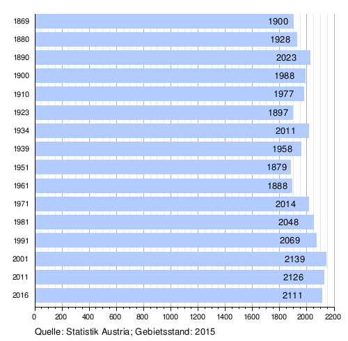
Population development
Religions
The majority of the population, namely 95.2%, profess the Roman Catholic faith; 0.6% are Protestant , 0.3% Muslim . 2.7% of the population are without religious beliefs.

Culture and sights
Economy and Infrastructure
traffic
Wechsel Straße B 54 runs through the municipality. In addition, in neighboring Sinabelkirchen there is a driveway to the south autobahn A 2 and thus a high-level connection to Hartberg and Vienna as well as to the provincial capital Graz . The district capital Weiz can be reached on a state road through the Ilztal.
The nearest train station is in Gleisdorf , from where the Styrian Eastern Railway can reach both the state capital Graz and the smaller towns of Feldbach and Fehring . There is also a branch line from Gleisdorf to Weiz ( Weizer Bahn ).
Established businesses
The economy is characterized by the predominance of small farms, many of which are part-time. Be built fruit and wine , which partly in taverns is marketed itself. There are also various commercial operations, e.g. B. Construction, timber trade, transport companies, local suppliers, etc.
politics
Parish council
The community board consists of the mayor Andreas Nagl, the deputy mayor Helmut Erlacher and the treasurer Herta Schnur (all ÖVP).
Municipal council
Since the municipal council elections in 2015, the council has been composed as follows:
coat of arms

Both previous municipalities had a municipality coat of arms. Due to the amalgamation of municipalities, these lost their official validity on January 1st, 2015.
In 1982, Governor Josef Krainer junior awarded the Ilztal community a coat of arms. The new award of this unchanged municipal coat of arms for the merged municipality took place on November 20, 2016.
The updated blazon reads:
- "In gold a blue pole, in the flanks six red balls touching each other and the edges of the shield, of which the lower one is cut."
Explanation: The continuous blue band in the middle of the coat of arms embodies the connecting Ilz. The golden areas on both sides represent the fields of wheat and the fertile Ilz valley. The red balls are symbols for all kinds of fruits that thrive here, as well as symbols for the fruits of the hardworking hands and fruits of spiritual work. (Quoted verbatim from the church website.)
Personalities
Honorary citizen
- 1982: Josef Krainer (1930–2016), Governor of Styria 1980–1996
Sons and daughters of the church
- Elfriede Hammerl (* 1945), journalist
Web links
- 61762 - Ilztal. Community data, Statistics Austria .
Individual evidence
- ^ Styrian municipal structural reform .
- ↑ Section 3, Paragraph 11, Item 1 of the Act of December 17, 2013 on the restructuring of the municipalities of the State of Styria ( Styrian Municipal Reform Act - StGsrG) Provincial Law Gazette for Styria of April 2, 2014. No. 31, year 2014. ZDB -ID 705127-x . P. 4.
- ↑ Statistics Austria: Population on January 1st, 2020 by locality (area status on January 1st, 2020) , ( CSV )
- ↑ 132. Announcement of the Styrian regional government of November 3, 2016 on the granting of the right to use a municipal coat of arms to the Ilztal municipality (political district of Weiz) , accessed on November 16, 2016
- ↑ Neues Land, No. 39 (10.10.1982), p. 7.

Albersdorf-Prebuch | Anger | Birkfeld | Fischbach | Fladnitz an der Teichalm | Floing | Gases | Gersdorf an der Feistritz | Gleisdorf | Gutenberg-Stenzengreith | Hofstätten an der Raab | Ilztal | Ludersdorf-Wilfersdorf | Hartmannsdorf market | Miesenbach near Birkfeld | Mitterdorf an der Raab | Mortantsch | Naas | Passail | Pischelsdorf am Kulm | Puch near Weiz | Rats | Rettenegg | St. Kathrein am Hauenstein | Sankt Kathrein am Offenegg | St. Margarethen an der Raab | Sankt Ruprecht an der Raab | Sinabelkirchen | Strallegg | Thannhausen | Wheat