
Barbery (Oise)
| Barbery | ||
|---|---|---|
|
||
| region | Hauts-de-France | |
| Department | Oise | |
| Arrondissement | Senlis | |
| Canton | Pont-Sainte-Maxence | |
| Community association | Senlis Sud Oise | |
| Coordinates | 49 ° 13 ′ N , 2 ° 40 ′ E | |
| height | 68-102 m | |
| surface | 7.6 km 2 | |
| Residents | 572 (January 1, 2017) | |
| Population density | 75 inhabitants / km 2 | |
| Post Code | 60810 | |
| INSEE code | 60045 | |
| Website | http://barbery.oise.free.fr/ | |
 Barbery Town Hall (Mairie) |
||

Barbery is a French municipality with 572 inhabitants (as of January 1 2017) in the department of Oise in the region of Hauts-de-France . Barbery belongs to the arrondissement of Senlis and the canton of Pont-Sainte-Maxence (until 2015: canton of Senlis ). The inhabitants are called Barberisiens .
geography
Barbery is a small suburb a few kilometers east of Senlis . Barbery is surrounded by the neighboring communities of Brasseuse in the north, Rully in the north and northeast, Montépilloy in the east and southeast, Borest in the south, Mont-l'Évêque in the southwest, Chamant in the west and Villers-Saint-Frambourg-Ognon with Ognon in the northwest.
Population development
| 1962 | 1968 | 1975 | 1982 | 1990 | 1999 | 2006 | 2013 |
|---|---|---|---|---|---|---|---|
| 554 | 531 | 480 | 452 | 483 | 518 | 501 | 558 |
| Source: Cassini and INSEE | |||||||
Attractions
- Saint-Rémy church from the 12th century, a historic monument since 1978
- Former mansion
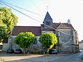
Saint-Rémy church

Former mansion
,_fa%C3%A7ade_sud_de_l%27%C3%A9glise_Saint-R%C3%A9mi.jpg)
,_boulangerie,_rue_du_G%C3%A9n%C3%A9ral_Patton.jpg)
Personalities
- Éloi-Charlemagne Taupin (1767–1814), division general
Web links
Commons : Barbery - collection of images, videos and audio files