
Salzburg-Tyrolean Railway
| Salzburg Hbf – Wörgl Hbf | |||||||||||||||||||||||||||||||||||||||||||||||||||||||||||||||||||||||||||||||||||||||||||||||||||||||||||||||||||||||||||||||||||||||||||||||||||||||||||||||||||||||||||||||||||||||||||||||||||||||||||||||||||||||||||||||||||||||||||||||||||||||||||||||||||||||||||||||||||||||||||||||||||||||||||||||||||||||||||||||||||||||||||||||||||||||||||||||||||||||||||||||||||||||||||||||||||||||||||||||||||||||||||||||||||||||||||||||||||||||||||||||||||||||||||||||||||||||||||||||||||||||||||||||||||||||||||||||||||||||||||||||||||||||||||||||||||||||||||||||||||||||||||||||||||||||||||||||||||||||||||||||||||||||||||||||||||||||||||||||||
|---|---|---|---|---|---|---|---|---|---|---|---|---|---|---|---|---|---|---|---|---|---|---|---|---|---|---|---|---|---|---|---|---|---|---|---|---|---|---|---|---|---|---|---|---|---|---|---|---|---|---|---|---|---|---|---|---|---|---|---|---|---|---|---|---|---|---|---|---|---|---|---|---|---|---|---|---|---|---|---|---|---|---|---|---|---|---|---|---|---|---|---|---|---|---|---|---|---|---|---|---|---|---|---|---|---|---|---|---|---|---|---|---|---|---|---|---|---|---|---|---|---|---|---|---|---|---|---|---|---|---|---|---|---|---|---|---|---|---|---|---|---|---|---|---|---|---|---|---|---|---|---|---|---|---|---|---|---|---|---|---|---|---|---|---|---|---|---|---|---|---|---|---|---|---|---|---|---|---|---|---|---|---|---|---|---|---|---|---|---|---|---|---|---|---|---|---|---|---|---|---|---|---|---|---|---|---|---|---|---|---|---|---|---|---|---|---|---|---|---|---|---|---|---|---|---|---|---|---|---|---|---|---|---|---|---|---|---|---|---|---|---|---|---|---|---|---|---|---|---|---|---|---|---|---|---|---|---|---|---|---|---|---|---|---|---|---|---|---|---|---|---|---|---|---|---|---|---|---|---|---|---|---|---|---|---|---|---|---|---|---|---|---|---|---|---|---|---|---|---|---|---|---|---|---|---|---|---|---|---|---|---|---|---|---|---|---|---|---|---|---|---|---|---|---|---|---|---|---|---|---|---|---|---|---|---|---|---|---|---|---|---|---|---|---|---|---|---|---|---|---|---|---|---|---|---|---|---|---|---|---|---|---|---|---|---|---|---|---|---|---|---|---|---|---|---|---|---|---|---|---|---|---|---|---|---|---|---|---|---|---|---|---|---|---|---|---|---|---|---|---|---|---|---|---|---|---|---|---|---|---|---|---|---|---|---|---|---|---|---|---|---|---|---|---|---|---|---|---|---|---|---|---|---|---|---|---|---|---|---|---|---|---|---|---|---|---|---|---|---|---|---|---|---|---|---|---|---|---|---|---|---|---|---|---|---|---|---|---|---|---|---|---|---|---|---|---|---|---|---|---|---|---|---|---|---|---|---|---|---|---|---|---|---|---|---|---|---|---|---|---|---|---|---|---|---|---|---|---|---|---|---|---|---|---|---|---|---|---|---|---|---|---|---|---|---|---|---|---|---|---|---|---|---|---|---|---|---|---|---|---|---|---|---|---|---|---|---|---|---|---|---|---|---|---|---|---|---|---|---|---|---|---|---|---|---|---|---|---|---|---|---|---|---|---|---|---|---|---|---|---|---|---|---|---|---|---|---|---|---|---|---|---|---|---|---|---|---|---|---|---|---|---|---|---|---|---|---|---|---|---|---|---|---|---|---|---|---|---|---|---|---|---|---|---|---|---|---|---|---|---|---|---|---|---|---|---|---|---|---|---|---|
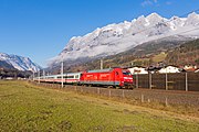
 EC 163 “ Transalpin ” passes the Kaiser Mountains.
| |||||||||||||||||||||||||||||||||||||||||||||||||||||||||||||||||||||||||||||||||||||||||||||||||||||||||||||||||||||||||||||||||||||||||||||||||||||||||||||||||||||||||||||||||||||||||||||||||||||||||||||||||||||||||||||||||||||||||||||||||||||||||||||||||||||||||||||||||||||||||||||||||||||||||||||||||||||||||||||||||||||||||||||||||||||||||||||||||||||||||||||||||||||||||||||||||||||||||||||||||||||||||||||||||||||||||||||||||||||||||||||||||||||||||||||||||||||||||||||||||||||||||||||||||||||||||||||||||||||||||||||||||||||||||||||||||||||||||||||||||||||||||||||||||||||||||||||||||||||||||||||||||||||||||||||||||||||||||||||||||
| Route number (ÖBB) : | 101 03 | ||||||||||||||||||||||||||||||||||||||||||||||||||||||||||||||||||||||||||||||||||||||||||||||||||||||||||||||||||||||||||||||||||||||||||||||||||||||||||||||||||||||||||||||||||||||||||||||||||||||||||||||||||||||||||||||||||||||||||||||||||||||||||||||||||||||||||||||||||||||||||||||||||||||||||||||||||||||||||||||||||||||||||||||||||||||||||||||||||||||||||||||||||||||||||||||||||||||||||||||||||||||||||||||||||||||||||||||||||||||||||||||||||||||||||||||||||||||||||||||||||||||||||||||||||||||||||||||||||||||||||||||||||||||||||||||||||||||||||||||||||||||||||||||||||||||||||||||||||||||||||||||||||||||||||||||||||||||||||||||||
| Course book route (ÖBB) : | 200 (Freilassing - Saalfelden) 201 (Saalfelden - Innsbruck Hbf) |
||||||||||||||||||||||||||||||||||||||||||||||||||||||||||||||||||||||||||||||||||||||||||||||||||||||||||||||||||||||||||||||||||||||||||||||||||||||||||||||||||||||||||||||||||||||||||||||||||||||||||||||||||||||||||||||||||||||||||||||||||||||||||||||||||||||||||||||||||||||||||||||||||||||||||||||||||||||||||||||||||||||||||||||||||||||||||||||||||||||||||||||||||||||||||||||||||||||||||||||||||||||||||||||||||||||||||||||||||||||||||||||||||||||||||||||||||||||||||||||||||||||||||||||||||||||||||||||||||||||||||||||||||||||||||||||||||||||||||||||||||||||||||||||||||||||||||||||||||||||||||||||||||||||||||||||||||||||||||||||||
| Route length: | 191.730 km | ||||||||||||||||||||||||||||||||||||||||||||||||||||||||||||||||||||||||||||||||||||||||||||||||||||||||||||||||||||||||||||||||||||||||||||||||||||||||||||||||||||||||||||||||||||||||||||||||||||||||||||||||||||||||||||||||||||||||||||||||||||||||||||||||||||||||||||||||||||||||||||||||||||||||||||||||||||||||||||||||||||||||||||||||||||||||||||||||||||||||||||||||||||||||||||||||||||||||||||||||||||||||||||||||||||||||||||||||||||||||||||||||||||||||||||||||||||||||||||||||||||||||||||||||||||||||||||||||||||||||||||||||||||||||||||||||||||||||||||||||||||||||||||||||||||||||||||||||||||||||||||||||||||||||||||||||||||||||||||||||
| Gauge : | 1435 mm ( standard gauge ) | ||||||||||||||||||||||||||||||||||||||||||||||||||||||||||||||||||||||||||||||||||||||||||||||||||||||||||||||||||||||||||||||||||||||||||||||||||||||||||||||||||||||||||||||||||||||||||||||||||||||||||||||||||||||||||||||||||||||||||||||||||||||||||||||||||||||||||||||||||||||||||||||||||||||||||||||||||||||||||||||||||||||||||||||||||||||||||||||||||||||||||||||||||||||||||||||||||||||||||||||||||||||||||||||||||||||||||||||||||||||||||||||||||||||||||||||||||||||||||||||||||||||||||||||||||||||||||||||||||||||||||||||||||||||||||||||||||||||||||||||||||||||||||||||||||||||||||||||||||||||||||||||||||||||||||||||||||||||||||||||||
| Network category : | A. | ||||||||||||||||||||||||||||||||||||||||||||||||||||||||||||||||||||||||||||||||||||||||||||||||||||||||||||||||||||||||||||||||||||||||||||||||||||||||||||||||||||||||||||||||||||||||||||||||||||||||||||||||||||||||||||||||||||||||||||||||||||||||||||||||||||||||||||||||||||||||||||||||||||||||||||||||||||||||||||||||||||||||||||||||||||||||||||||||||||||||||||||||||||||||||||||||||||||||||||||||||||||||||||||||||||||||||||||||||||||||||||||||||||||||||||||||||||||||||||||||||||||||||||||||||||||||||||||||||||||||||||||||||||||||||||||||||||||||||||||||||||||||||||||||||||||||||||||||||||||||||||||||||||||||||||||||||||||||||||||||
| Power system : | 15 kV / 16.7 Hz ~ | ||||||||||||||||||||||||||||||||||||||||||||||||||||||||||||||||||||||||||||||||||||||||||||||||||||||||||||||||||||||||||||||||||||||||||||||||||||||||||||||||||||||||||||||||||||||||||||||||||||||||||||||||||||||||||||||||||||||||||||||||||||||||||||||||||||||||||||||||||||||||||||||||||||||||||||||||||||||||||||||||||||||||||||||||||||||||||||||||||||||||||||||||||||||||||||||||||||||||||||||||||||||||||||||||||||||||||||||||||||||||||||||||||||||||||||||||||||||||||||||||||||||||||||||||||||||||||||||||||||||||||||||||||||||||||||||||||||||||||||||||||||||||||||||||||||||||||||||||||||||||||||||||||||||||||||||||||||||||||||||||
| Maximum slope : | 27 ‰ | ||||||||||||||||||||||||||||||||||||||||||||||||||||||||||||||||||||||||||||||||||||||||||||||||||||||||||||||||||||||||||||||||||||||||||||||||||||||||||||||||||||||||||||||||||||||||||||||||||||||||||||||||||||||||||||||||||||||||||||||||||||||||||||||||||||||||||||||||||||||||||||||||||||||||||||||||||||||||||||||||||||||||||||||||||||||||||||||||||||||||||||||||||||||||||||||||||||||||||||||||||||||||||||||||||||||||||||||||||||||||||||||||||||||||||||||||||||||||||||||||||||||||||||||||||||||||||||||||||||||||||||||||||||||||||||||||||||||||||||||||||||||||||||||||||||||||||||||||||||||||||||||||||||||||||||||||||||||||||||||||
| Minimum radius : | 227 m | ||||||||||||||||||||||||||||||||||||||||||||||||||||||||||||||||||||||||||||||||||||||||||||||||||||||||||||||||||||||||||||||||||||||||||||||||||||||||||||||||||||||||||||||||||||||||||||||||||||||||||||||||||||||||||||||||||||||||||||||||||||||||||||||||||||||||||||||||||||||||||||||||||||||||||||||||||||||||||||||||||||||||||||||||||||||||||||||||||||||||||||||||||||||||||||||||||||||||||||||||||||||||||||||||||||||||||||||||||||||||||||||||||||||||||||||||||||||||||||||||||||||||||||||||||||||||||||||||||||||||||||||||||||||||||||||||||||||||||||||||||||||||||||||||||||||||||||||||||||||||||||||||||||||||||||||||||||||||||||||||
| Top speed: | 130 km / h | ||||||||||||||||||||||||||||||||||||||||||||||||||||||||||||||||||||||||||||||||||||||||||||||||||||||||||||||||||||||||||||||||||||||||||||||||||||||||||||||||||||||||||||||||||||||||||||||||||||||||||||||||||||||||||||||||||||||||||||||||||||||||||||||||||||||||||||||||||||||||||||||||||||||||||||||||||||||||||||||||||||||||||||||||||||||||||||||||||||||||||||||||||||||||||||||||||||||||||||||||||||||||||||||||||||||||||||||||||||||||||||||||||||||||||||||||||||||||||||||||||||||||||||||||||||||||||||||||||||||||||||||||||||||||||||||||||||||||||||||||||||||||||||||||||||||||||||||||||||||||||||||||||||||||||||||||||||||||||||||||
| Dual track : | Salzburg Hbf – Wörgl Hbf | ||||||||||||||||||||||||||||||||||||||||||||||||||||||||||||||||||||||||||||||||||||||||||||||||||||||||||||||||||||||||||||||||||||||||||||||||||||||||||||||||||||||||||||||||||||||||||||||||||||||||||||||||||||||||||||||||||||||||||||||||||||||||||||||||||||||||||||||||||||||||||||||||||||||||||||||||||||||||||||||||||||||||||||||||||||||||||||||||||||||||||||||||||||||||||||||||||||||||||||||||||||||||||||||||||||||||||||||||||||||||||||||||||||||||||||||||||||||||||||||||||||||||||||||||||||||||||||||||||||||||||||||||||||||||||||||||||||||||||||||||||||||||||||||||||||||||||||||||||||||||||||||||||||||||||||||||||||||||||||||||
|
|||||||||||||||||||||||||||||||||||||||||||||||||||||||||||||||||||||||||||||||||||||||||||||||||||||||||||||||||||||||||||||||||||||||||||||||||||||||||||||||||||||||||||||||||||||||||||||||||||||||||||||||||||||||||||||||||||||||||||||||||||||||||||||||||||||||||||||||||||||||||||||||||||||||||||||||||||||||||||||||||||||||||||||||||||||||||||||||||||||||||||||||||||||||||||||||||||||||||||||||||||||||||||||||||||||||||||||||||||||||||||||||||||||||||||||||||||||||||||||||||||||||||||||||||||||||||||||||||||||||||||||||||||||||||||||||||||||||||||||||||||||||||||||||||||||||||||||||||||||||||||||||||||||||||||||||||||||||||||||||||
Coordinates: 47 ° 29 ′ 30.2 ″ N , 12 ° 3 ′ 39.6 ″ E The Salzburg-Tiroler-Bahn is a main line in Austria . It runsfrom Salzburg to Wörgl in the federal states of Salzburg and Tyrol and is part of the core network of the Austrian Federal Railways (ÖBB).
The line has been expanded to consist of two tracks and will be used in track changing mode, the regular track on the right. The entire line is electrified and operated with 15,000 volts alternating current and a frequency of 16.7 Hz .
In particular, the section of Salzburg main station to Schwarzach - St. Veit was - in connection with the Tauernbahn and the establishment of the S-Bahn Salzburg extensively expanded the track and places new - traced out .
Names
The railway line is (or was) also called Giselabahn (after the second daughter of Emperor Franz Joseph I and his wife Elisabeth of Austria-Hungary , Archduchess Gisela Louise Marie of Austria ). Today it is often understood as part of the Western Railway ; the section of the route Wien Westbf – Linz – Salzburg – Zell am See – Wörgl is also known as the Kaiserin-Elisabeth-Bahn , and the section from Zell am See – Wörgl as the Brixentalbahn .
history
Tyrol had been connected to Salzburg and the east of Austria by railroad since 1858, but the route ran over Bavarian territory ( Bayerische Maximiliansbahn ), which was seen as a strategic disadvantage, especially after the dissolution of the German Confederation in 1866 and increasing tensions with Bavaria. Therefore, in addition to the Pustertalbahn, which opened in 1871, another inner-Austrian east-west connection was planned, which should also be connected to the Kronprinz-Rudolf-Bahn .
On the basis of the concession deed of November 10th, 1872, the Salzburg-Tiroler-Bahn was built from 1873 to 1875 for the stock company of the privileged Empress Elisabethbahn for the construction and operation of a locomotive railway leading from Upper Styria to Salzburg and North Tyrol . It leads from Salzburg via Hallein , Bischofshofen , St. Johann im Pongau , Schwarzach - St. Veit , Zell am See , Hochfilzen , St. Johann in Tirol , Kitzbühel to Wörgl .
The standard gauge line runs through the Salzach Valley , with the Bischofshofen station being particularly important due to the branching off to the Ennstalbahn . At Wörgl, the Salzburg-Tiroler-Bahn meets the Munich – Innsbruck or Salzburg – Deutsches Eck –Innsbruck railway line .
In 1905 the north ramp of the Tauern Railway between Schwarzach-St. Veit , which lies on the Salzburg-Tiroler-Bahn, and Bad Gastein opened, in 1909 the Tauernbahn including the Tauernschleuse to Villach was completed.
In 1915 the Salzburg-Tyrolean Railway was expanded to two tracks. The electrification of the line began in 1925 and was completed in 1930.
In the first Austrian republic, the line was the responsibility of the Innsbruck Federal Railway Directorate . After Austria was annexed in 1938, it operated briefly as the Innsbruck Railway Directorate before it was dissolved on July 15, 1938. The route was subordinated to the Reich Railway Directorate Linz . After 1945 the ÖBB was re-established, the management structure from the time before 1938 was re-established, including the Federal Railway Directorate Innsbruck.
Towards the end of the Second World War , the Salzburg-Tiroler-Bahn was the target of Allied bombing attacks due to its strategic importance.
Importance and operation
Today, the Salzburg-Tiroler-Bahn is the only east-west railway connection that runs exclusively on Austrian territory. In particular, the fact that there is no motorway connection between the federal states of Salzburg and Tyrol on Austrian territory made the route very important. However, since Austria joined the EU in 1995, its importance has increasingly diminished, also because, due to its characteristics as an Alpine railway, high speeds are not possible. The ÖBB therefore preferably uses the route from Salzburg via Rosenheim to Innsbruck via the (Great) German Corner for long-distance connections .
The route is particularly important in regional traffic, as part of the connection from Innsbruck to Klagenfurt and Graz and as part of the line from Salzburg to Graz via the Ennstalbahn. The only Austrian bus connection from North Tyrol to East Tyrol begins in Kitzbühel on the Salzburg-Tiroler Bahn . The route is of certain importance as an alternative route for international rail traffic on the east-west axis, but it is of greater importance as a feeder route for the Tauernbahn in the north-south Alpine transit . The Salzburg-Tiroler Bahn is also used for night train traffic. The night train from Bregenz to Vienna ran here until December 2008 in order to save rail tolls to Deutsche Bahn for the use of the Great German Corner. The railway line is also of great importance due to the local traffic in the central area of Salzburg. Between Salzburg Hbf and Golling-Abtenau, the route is operated every half hour and from Golling to Schwarzach every hour by the S3 line of the Salzburg S-Bahn . On weekdays the line runs every two hours from Schwarzach-St. Veit out to Saalfelden. The S6 of the S-Bahn Tirol runs every hour between Hochfilzen and Wörgl , some connections continue to Saalfelden.
The last railroad crossing in the Tyrolean Brixental has been history since April 29, 2011. The last barred level crossing was replaced by an underpass. From Roppen im Oberinntal to the Kitzbühel-Hahnenkamm stop, there is no longer a level crossing (apart from a railroad crossing in Wörgl Terminal North that is used purely for truck loading and is secured with light signals).
photos

Near Brixen im Thale

Freight train with 1110 524-4 near Zell am See
At Pfarrwerfen.

Route at the Salzachöfen


Web links
literature
- Alfred Horn: The railways in Austria. Official anniversary book for the 150th anniversary. Bohmann, Vienna 1986, ISBN 3-7002-0643-7 .
- Alfred Horn: ÖBB Handbuch 1993. Bohmann, Vienna 1993, ISBN 3-7002-0824-3 .
- Railway Atlas Austria. Schweers + Wall, Aachen 2005, ISBN 3-89494-128-6 , p. 63.
- Michael Alexander Populorum: 150 Years of the Railway in Salzburg 1860–2010. A small obituary for the anniversary of the “Railway Development ” of the State of Salzburg in August 2010. Series of publications by the Documentation Center for European Railway Research (DEEF), Volume 1, 2010, 3rd edition 2017 on DVD, ISBN 978-3-903132-06-1 . Mercurius Verlag Grödig / Salzburg. Railway Research Austria.
- Helmut K. Missbach: Railways in Tyrol. Prehistory - railway construction - operation . Motorbuch Verlag, Stuttgart 1979, ISBN 3-87943-640-1 , p. 71-82 .
Individual evidence
- ↑ Itter tunnel: 45.30 meters on eisenbahntunnel.at, accessed on August 12, 2017
- ↑ Volkswirthschaftliche Zeitung. (...) Giselabahn. In: Das Vaterland , No. 314/1872 (XIIIth year), November 15, 1872, p. 5 (unpaginated), column 2 middle. (Online at ANNO ). .
- ↑ RGBl. 1872/170. In: Reichsgesetzblatt for the kingdoms and states represented in the Reichsrathe , year 1872, pp. 587–614. (Online at ANNO ). ; Volkswirthschaftliche Zeitung. (...) Giselabahn. In: Das Vaterland , No. 359/1872 (XIIIth year), December 31, 1872, p. 3 (unpaginated), column 3 below. (Online at ANNO ). .
- ↑ Deutsche Reichsbahn-Gesellschaft (Ed.): Official Gazette of the Reichsbahndirektion Mainz of August 6, 1938, No. 36. Announcement No. 488, p. 213.
- ↑ Railway barriers are history - the Brixental is free of crossings. The underpass in Brixen was opened. ( Memento from September 17, 2012 in the web archive archive.today )