
Broye (river)
| Broye | ||
.png) Course of the Broye |
||
| Data | ||
| Water code | CH : 215 | |
| location | West Swiss Plateau
|
|
| River system | Rhine | |
| Drain over | Zihl Canal → Aare → Rhine → North Sea | |
| source | Les Alpettes (Ruisseau des Mosses) 46 ° 34 ′ 53 ″ N , 6 ° 57 ′ 50 ″ E |
|
| Source height | approx. 1245 m above sea level M. | |
| muzzle |
Lake Neuchâtel coordinates: 46 ° 58 ′ 49 ″ N , 7 ° 2 ′ 13 ″ E ; CH1903: 569 432 / 203336 46 ° 58 '49 " N , 7 ° 2' 13" O |
|
| Mouth height | 429 m above sea level M. | |
| Height difference | approx. 816 m | |
| Bottom slope | approx. 9.2 ‰ | |
| length | 88.9 km | |
| Catchment area | 851 km² | |
| Discharge at the Sugiez A Eo gauge : 713 km² Location: 7 km above the estuary |
NNQ (August 2005) MNQ 1984–2016 MQ 1984–2016 Mq 1984–2016 MHQ 1984–2016 HHQ (April 2006) |
-27.9 m³ / s 5.38 m³ / s 11.2 m³ / s 15.7 l / (s km²) 18.9 m³ / s 159 m³ / s |
| Outflow A Eo : 851 km² at the mouth |
MQ 1961-1980 Mq 1961-1980 |
12.3 m³ / s 14.5 l / (s km²) |
| Left tributaries | Carrouge , Lembe , Parimbot , Petite Glâne , | |
| Right tributaries | Mionne , Biberen , Arbogne | |
 The Broye at Moudon |
||

| ||
Source and mouth of the Broye
|
The Broye ([ bʀwa ]; Friborg patois , mentioned as Brodiam as early as 1155 ) is a 89 km long river in the western Swiss plateau with a catchment area of around 850 km² and an average water flow of a good 12 m³ / s. The German name Brüw is no longer used even in German-speaking Switzerland. On the other hand, the pronunciation [ ˈbro () jə ] has become common here.
geography
course
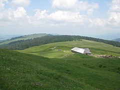
Several small spring streams on the western slope of the Niremont and the Alpettes in the Freiburg Pre-Alps south-west of Bulle unite at Semsales to form the Broye. This flows first to the southwest parallel to the foothills of the Alps, but then changes direction after about 10 km abruptly to the north into the Swiss plateau. Between Oron-la-Ville and Moudon , it runs first in an open valley into which it has dug like a gorge south of Moudon. At Moudon the general direction of flow changes again, this time to the northeast. Between Moudon and Payerne , the Broye uses a valley carved out by the Ice Age Rhone glacier with a wide, flat valley floor and steep, e.g. T. rocky slopes.
At Payerne the Broyetal opens up into a wide, up to 5 km wide valley depression with intensive agricultural use. Shortly before its confluence with the Murten lake , the Broye takes on its longest tributary, the Petite Glâne , from the left . The Broye leaves Lake Murten at its northeast corner. Then it runs in a canal bed from the Jura water correction around Mont Vully to the west into Lake Neuchâtel . This last section between Lake Murten and Lake Neuchâtel is also called Broyekanal (French: Canal de la Broye ). A canal with a similar course was already used by the Romans, among other things for long-distance trade and for the procurement of materials for the construction of Aventicum (quarries in the Jura ). Further tributaries are the Carrouge and Lembe from the left and the Arbogne from the right .
Only in the upper reaches of the Broye still has near-natural banks, below Moudon it was canalized and straightened as a result of numerous floods in the flat valley floor in the 19th and early 20th centuries.
- The Broye
Headwaters of the Broye
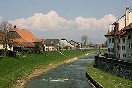
The Broye in Payerne

The Broye at Maracón
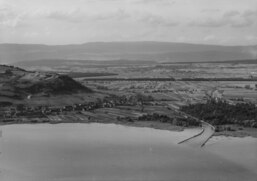
Aerial view of the Broye Canal (1954), in front the Murten lake


Catchment area
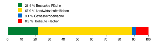
The catchment area of the Broye is 851.16 km² and consists of 21.4% forest land , 67.0% agricultural area , 3.1% water surface and 8.3% settlement area .
The mean height of the catchment area is 615 m above sea level. M. , the minimum height is 427 m above sea level. M. and the maximum height at 1512 m above sea level. M.
Tributaries
Inflows from the source to the mouth (length, basin , MQ ):
- Broye
- Le Ruisseau des Planes ( left ), 2.2 km
- Le Ruisseau des Gro Troncs ( left ), 1.3 km
- Le Ruisseau de la Cierne ( left ), 2.6 km, 0.95 km²
- Le Ruisseau du Moyon ( left ), 2.1 km, 1.17 km²
- Le Ruisseau de la Villette ( left ), 0.9 km
- La Mortivue ( left ), 5.3 km, 4.12 km², 0.15 m³ / s
- La Rougève ( right ), 1.5 km
- Le Riau Vesénand ( left ), 4.0 km, 3.47 km²
- Le Dâ ( left ), 5.1 km, 7.83 km², 0.23 m³ / s
- Le Ruisseau de la Corna ( left )
- Le Ruisseau du Charavet ( left )
- Riau Mettraux ( left )
- Le Tatrel ( left ), 4.5 km, 7.66 km², 0.18 m³ / s
- La Crottaz ( right ), 3.0 km, 1.42 km²
- La Teisigne ( right ), 2.6 km, 1.70 km²
- La Biorde ( left ), 9.9 km, 24.84 km², 0.55 m³ / s

- La Mionne ( right ), 11.4 km, 18.24 km², 0.41 m³ / s
- Le Ruisseau d'Haut Crêt ( left ), 1.2 km
- Le Ruisseau de Flon d'Oron ( right ), 10.6 km, 15.92 km², 0.37 m³ / s
- Le Grenet ( left ), 14.2 km, 28.61 km², 0.60 m³ / s
- Le Ruisseau de Vuibroye ( left ), 2.3 km
- Le Ruisseau de l'Eterpi ( La Longive ) ( right ), 2.9 km, 2.45 km²
- Le Ruisseau des Torrents ( right ), 2.2 km
- Le Ruisseau de l'Etang ( right ), 1.8 km
- Le Ruisseau des Clos ( right ), 0.2 km
- Le Parimbot ( left ), 7.1 km, 7.79 km², 0.16 m³ / s
- Le Ruisseau du Passiau ( right ), 3.4 km, 3.41 km²
- Le Ruisseau du Charrotton ( right ), 4.5 km, 6.31 km², 0.13 m³ / s
- Le Ruisseau des Chavannettes ( right ), 3.8 km, 3.12 km²
- Le Ruisseau de Vuaz ( right ), 4.2 km, 3.71 km², 0.07 m³ / s
- Le Ruisseau de la Croix ( right ), 0.7 km, 1.86 km²

- Le Carrouge ( left ), 16.3 km, 50.9 km², 1.07 m³ / s
- Le Ruisseau de la Rapaz ( left ), 0.9 km
- Le Ruisseau de Valacrêt ( left ), 1.0 km
- La Mérine ( left ), 9.6 km, 18.15 km², 0.31 m³ / s
- Le Ruisseau de la Brasserie ( right ), 0.5 km
- Le Ruisseau de de Vaucegnery ( right ), 1.2 km, 1.09 km²
- Le Riau Gresin ( left ), 3.5 km, 1.94 km²
- Le Ruisseau de Voraire ( left ), 1.9 km, 2.09 km²
- Le Ruisseau de la Gotte ( right ), 1.7 km,
- La Cerjaule ( left ), 9.9 km, 18.65 km², 0.29 m³ / s
- Le Ruisseau des Vaux ( right ), 7.5 km, 10.93 km², 0.19 m³ / s
- Le Ruisseau de Riche ( Le Ruisseau de Prassy ) ( right ), 2.4 km, 1.82 km²
- Le Ruisseau de la Braye ( right ), 0.9 km
- Le Ruisseau de la Pièce ( right ), 1.1 km
- Le Ruisseau des Gros Essorts ( left ), 0.8 km
- Le Ruisseau des Iles ( left ), 0.8 km, 0.79 km²
- Le Ruisseau des Baumes ( left ), 0.9 km, 0.96 km²
- Le Ruisseau de Seigneux ( Le Ruisseau des Champs Ferlins ) ( right ), 4.5 km, 7.15 km², 0.12 m³ / s
- Le Flon ( left ), 0.9 km, 0.96 km²
- La Trémeule ( right ), 3.6 km, 4.93 km², 0.08 m³ / s
- Le Vauban ( left ), 1.4 km, 1.61 km²
- Le Ruisseau de Marnand ( right ), 8.4 km, 10.13 km², 0.17 m³ / s

- La Lembe ( La Lembaz ) ( left ), 14.3 km, 26.69 km², 0.41 m³ / s
- Le Ruisseau de Trey ( right ), 2.5 km, 2.45 km²
- Le Ruisseau de Monteman ( left ), 5.5 km, 7.41 km², 0.11 m³ / s
- Le Ruisseau de la Biolleyre ( left ), 0.2 km
- La Bioleyre ( right ), 4.6 km, 7.84 km², 0.11 m³ / s
- Le Ruisseau du Châtelard ( right ), 0.7 km
- Le Ruisseau de Moille Saulaz ( right ), 0.3 km
- La Coula ( left ), 1.9 km, 3.81 km², 0.04 m³ / s
- Canal de Sésines ( right ), 6.6 km, 8.97 km², 0.10 m³ / s
- L'Arbogne ( right ), 31.1 km, 72.17 km², 0.83 m³ / s
- La Petite Glâne ( left ), 30.4 km, 100.54 km², 1.12 m³ / s
- Lac de Morat
- Le Bay ( right ), 5.8 km, 5.5 km²
- L'Eau Noire ( right ), 4.0 km, 5.6 km², 0.07 m³ / s
- Le Ruisseau de Marnand ( right ), 8.4 km, 10.13 km², 0.17 m³ / s

- Le Chandon ( right ), 17.3 km, 38.19 km², 0.5 m³ / s
- Ruisseau des Ferrages ( left ), 1.1 km, 0.61 km²
- Ruisseau de Forel ( left ), 1.1 km, 1.93 km²
- Dybach ( Ruisseau de Dy ) ( right ), 3.6 km ( Dybach-Ruisseau du Moulin strand 5.2 km), 7.92 km², 0.1 m³ / s
- Ruisseau de Champ Perbou ( left ), 0.4 km, 0.63 km²
- Prehlbach ( Muhlebach ) ( right ), 4.9 km, 4.23 km²
- Muntelierbach ( Rugang Bach ) ( right ), 0.4 km, 1.29 km²
- Löwenbergbach ( Burggrabe ) ( right ), 3.2 km, 3.62 km², 0.05 m³ / s
- Alti Bibere ( right ), 1.0 km, 0.6 km²
- Canal de la Broye
- Grand Canal ( right ), 8.7 km ( Grand Canal-Biberenkanal- Biberen strand 24.8 km), 83.12 km², 0.88 m³ / s
- Main canal ( right ), 11.2 km, 4.94 km², 0.37 m³ / s
- Schwarzgraben ( right ), 1.5 km
- Alte Schwarzgrabe ( right )
- Mosimann Canal ( right ), 1.4 km
- Neuhof Canal ( right ), 1.1 km
Web links
- Marianne Rolle: Broye (river). In: Historical Lexicon of Switzerland .
Individual evidence
- ↑ a b Geoserver of the Swiss Federal Administration ( information )
- ↑ a b Federal Office for Topography, Federal Office for the Environment: Geoportal of Switzerland (Geocatalogue - Nature and Environment - River Regulations)
- ↑ Topographical catchment areas of Swiss waters: area outlets. Retrieved May 30, 2019 .
- ↑ Measurement station Canal de la Broye Sugiez 1984–2016 (PDF) Federal Office for the Environment FOEN
- ↑ a b Hydrological Atlas of Switzerland of the Federal Office for the Environment FOEN, Table_54
- ↑ Federal Office for Topography, Federal Office for the Environment: Geoportal der Schweiz (geocatalogue - nature and environment - area outlets)
- ↑ Values according to the Swiss geoportal , names according to the official survey plan (canton Friborg), Guichet cartographique cantonal (canton Vaud) or the geoportal canton Bern
- ↑ Name for the lower course
- ↑ a b Name for the upper course
Rivers with a total length of more than 30 km:
Aare |
Albula |
Allaine |
Old Rhine |
Arbogne |
Areuse |
Swiss stone pine |
Birs |
Brenno |
Broye |
Calancasca |
Doubs |
Drance de Bagnes |
Thinning |
Emme |
Engelberger Aa |
Ergolz |
Glâne |
Smooth |
Glenner (Glogn) |
Hinterrhein |
Inn (En) |
Julia (Gelgia) |
Kander |
Little Emme |
Landquart |
Land water |
Langete |
Limmat |
Linth |
Lorze |
Maggia |
Mentue |
Moësa |
Muota |
Murg |
Necker |
Orbe |
Petite Glâne |
Plessur |
Rabiusa |
Reuss |
Rhine |
Rhone |
Saane |
Schüss (Suze) |
Seez |
Scythe |
Sihl |
Simme |
Sitter |
Sorne |
Suhre |
Talent |
Tamina |
Ticino (Ticino) |
Thur |
Töss |
Venoge |
Verzasca |
Vispa |
Vorderrhein |
Wigger |
Wyna