
Cassagnes (Lot)
| Cassagnes | ||
|---|---|---|
|
||
| region | Occitania | |
| Department | Lot | |
| Arrondissement | Cahors | |
| Canton | Puy-l'Évêque | |
| Community association | Vallée du Lot et du Vignoble | |
| Coordinates | 44 ° 34 ′ N , 1 ° 8 ′ E | |
| height | 148-300 m | |
| surface | 11.62 km 2 | |
| Residents | 181 (January 1, 2017) | |
| Population density | 16 inhabitants / km 2 | |
| Post Code | 46700 | |
| INSEE code | 46061 | |
| Website | www.cassagnes.fr | |
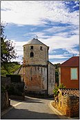
_-_Cimeti%C3%A8re_et_%C3%A9glise_Saint-Julien-de-Brioude.jpg) Parish Church of Saint-Julien-de-Brioude |
||

Cassagnes is a French commune with 181 inhabitants (as of January 1, 2017) in the Lot department in the Occitanie region (before 2016: Midi-Pyrénées ). The municipality belongs to the arrondissement of Cahors and the canton of Puy-l'Évêque .
The name of the community comes from the Latin cassanea ( German oak forest ). It refers to an earlier oak forest that was cleared to make way for fields and a village.
The inhabitants are called Cassagnais and Cassagnaises .
geography
Cassagnes is located about 28 kilometers northwest of Cahors in the historic province of Quercy on the western border with the neighboring Dordogne department .
Cassagnes is surrounded by the five neighboring communities:
|
Loubejac (Dordogne) |
Frayssinet-le-Gélat | |
| Montcabrier |
.svg)
|
Pomarède |
| Puy-l'Évêque |
Cassagnes lies in the catchment area of the Garonne River .
The Thèze , a tributary of the Lot , crosses the territory of the commune.
history
During the French Revolution , Cassagnes were incorporated into the municipality of Pomarède. In 1867 Cassagnes became independent again.
Population development
When it became independent in 1867, the number of inhabitants was at a high of 630. In the period that followed, the size of the community fell to around 200 inhabitants, with short recovery phases by the 1960s. This was followed by a brief period of growth before the number of residents stabilized at a level of around 200, which is still held today.
| year | 1962 | 1968 | 1975 | 1982 | 1990 | 1999 | 2006 | 2011 | 2017 |
|---|---|---|---|---|---|---|---|---|---|
| Residents | 201 | 234 | 260 | 195 | 212 | 192 | 205 | 204 | 181 |

Attractions
Parish Church of Saint-Julien-de-Brioude
The outdated style of the sculpted parts of the northern entrance portal means that it dates back to the end of the 11th century. The apse and part of the walls of the nave were not erected before the early 12th century, in keeping with the style of the choir capitals . The western entrance portal dates from the end of the 13th century or the beginning of the 14th century. Extensive restoration work took place in the late 1890s when the church threatened to collapse.
The south portal and the consoles of the apse are decorated with geometric motifs, animals and human heads. Two heads also embellish the lower ends of the outer archivolt of the west portal. The capitals of the choir show a more elaborate sculpture with two angels, one Mandorla carry, and the Archangel Michael and the dragon at the window of the transverse axis, an herbal decor, the Last Supper of Jesus , the women at the empty tomb and the Adoration of the Magi on the capitals on the double arches and the triumphal arch .
The church has been inscribed as a Monument historique since September 19, 2017 .
A statue of the Virgin Mary from the 18th century, the altarpiece from the 17th century and a holy water font from the late 18th century are inscribed as a monument historique of movable property.

Saint-Julien-de-Brioude parish church , south facade
apse

South portal
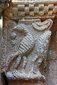
Decoration on the south portal

Decoration on the south portal
_-_Fa%C3%A7ade_de_l%27%C3%A9glise_Saint-Julien-de-Brioude.jpg)
_-_Chevet_de_l%27%C3%A9glise_Saint-Julien-de-Brioude.jpg)


Larroque castle ruins
It is located at about 100 meters on a slight rise above the Ruisseau de Frayssinet. A wetland extends on the north side, from which a spring rises on the steep slope as well as the fortifications. The remains of the castle date from the 13th or 14th century. It could be the noble residence de la Roque act in the jurisdiction of Montcabrier, the 1504 as a sub-fief Cuzorn was administered by Antoine de Luzech the house. A ruined castle in the hamlet of Larroque is shown on the map of Cassini from 1750.
A natural stone arch is located at the entrance to the site. Southeast thereof, a high wall extends works and rubble . It is the most important remnant of a building, the other walls of which have crumbled. The hill opposite the site, north of route départementale 673, contains many grottos that could be used by the residents of the castle, because there are a lot of stones that may have come from the buildings that have disappeared.
Economy and Infrastructure

Cassagnes is in the AOC zones
- the blue cheese Bleu des Causses ,
- the Noix du Périgord , the walnuts of the Périgord , and
- of the Périgord nut oil.

Total = 21
sport and freetime
The GR 652, a byway of the Camino de Santiago Via Podiensis via Rocamadour , partly runs along the border to the neighboring communities of Pomarède and Puy-l'Évêque.
traffic
Cassagnes can be reached via Routes départementales 28 and 673, the former Route nationale 673 .
Web links
- Information about the blue cheese Bleu des Causses (French)
- Information on Périgord walnuts and Périgord nut oil (French)
Individual evidence
- ^ Jean-Marie Cassagne: Villes et Villages en pays lotois ( fr ) Tertium éditions. Pp. 66, 231. 2013. Retrieved June 25, 2019.
- ↑ Lot ( fr ) habitants.fr. Retrieved June 24, 2019.
- ^ Ma commune: Cassagnes ( fr ) Système d'Information sur l'Eau du Bassin Adour Garonne. Retrieved June 25, 2019.
- ↑ a b Notice Communale Cassagnes ( fr ) EHESS . Retrieved June 24, 2019.
- ↑ Populations légales 2016 Commune de Cassagnes (46061) ( fr ) INSEE . Retrieved June 24, 2019.
- ↑ église paroissiale Notre-Dame de l'Assomption ( fr ) French Ministry of Culture . November 26, 2015. Accessed June 25, 2019.
- ^ Eglise ( fr ) French Ministry of Culture . February 15, 2018. Retrieved June 25, 2019.
- ↑ église Saint-Julien ( fr ) French Ministry of Culture . Retrieved June 25, 2019.
- ↑ château fort de Larroque ( fr ) French Ministry of Culture . November 26, 2015. Accessed June 25, 2019.
- ↑ Institut national de l'origine et de la qualité: Rechercher un produit ( fr ) Institut national de l'origine et de la qualité . Retrieved June 24, 2019.
- ↑ Caractéristiques des établissements en 2015 Commune de Cassagnes (46061) ( fr ) INSEE . Retrieved June 24, 2019.
- ↑ L'alternative par Rocamadour ( fr ) Agence de Coopération Interrégionale et Réseau “Chemins de Saint-Jacques de Compostelle”. Retrieved June 25, 2019.