
Frégimont
| Frégimont | ||
|---|---|---|

|
|
|
| region | Nouvelle-Aquitaine | |
| Department | Lot-et-Garonne | |
| Arrondissement | Agen | |
| Canton | Le Confluent | |
| Community association | Confluent et Coteaux de Prayssas | |
| Coordinates | 44 ° 17 ′ N , 0 ° 28 ′ E | |
| height | 73-200 m | |
| surface | 7.59 km 2 | |
| Residents | 259 (January 1, 2017) | |
| Population density | 34 inhabitants / km 2 | |
| Post Code | 47130 | |
| INSEE code | 47104 | |
| Website | http://www.fregimont.free.fr/ | |
 Town hall (Mairie) of Frégimont |
||

Frégimont is a French municipality with 259 inhabitants (at January 1, 2017) in the department of Lot-et-Garonne in the region Nouvelle-Aquitaine (before 2016 Aquitaine ). The municipality belongs to the Arrondissement of Agen and the canton of Le Confluent ( Port-Sainte-Marie until 2015 ).
geography
Frégimont is about 16 kilometers west-northwest of Agen . Frégimont is surrounded by the neighboring communities of Saint-Salvy in the north and north-west, Prayssas in the east and north-east, Lusignan-Petit in the east and south-east, Clermont-Dessous in the south and Bazens in the west and south-west.
Population development
| 1962 | 1968 | 1975 | 1982 | 1990 | 1999 | 2006 | 2013 | |
|---|---|---|---|---|---|---|---|---|
| 291 | 231 | 223 | 202 | 197 | 189 | 233 | 293 | |
| Source: Cassini and INSEE | ||||||||
Attractions
- Sainte-Quitterie church from 1506, monument historique since 1952
- Church of Sainte-Raffine in Gaujac from the 11th century, monument historique since 1947
- Frégimont Castle, now the town hall, built around 1775, monument historique since 2008

Sainte-Quitterie church
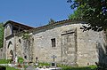
Sainte-Raffine Church


Web links
Commons : Frégimont - collection of images, videos and audio files