Saint-Hilaire-de-Lusignan
| Saint-Hilaire-de-Lusignan | ||
|---|---|---|

|
|
|
| region | Nouvelle-Aquitaine | |
| Department | Lot-et-Garonne | |
| Arrondissement | Agen | |
| Canton | L'Ouest Agenais | |
| Community association | Agen | |
| Coordinates | 44 ° 14 ′ N , 0 ° 31 ′ E | |
| height | 32-196 m | |
| surface | 16.77 km 2 | |
| Residents | 1,491 (January 1, 2017) | |
| Population density | 89 inhabitants / km 2 | |
| Post Code | 47450 | |
| INSEE code | 47246 | |
| Website | http://www.sainthilairedelusignan.fr/ | |
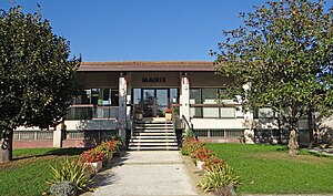
 Town hall (Mairie) of Saint-Hilaire-de-Lusignan |
||
Saint-Hilaire-de-Lusignan is a French commune with 1,491 inhabitants (as of January 1 2017) in the department of Lot-et-Garonne in the region Nouvelle-Aquitaine . Saint-Hilaire-de-Lusignan is located in the arrondissement of Agen and belongs to the canton of L'Ouest Agenais (until 2015: canton of Agen-Nord ).
geography
Saint-Hilaire-de-Lusignan is located about eight kilometers west-northwest of Agen on the Garonne River , which forms the western or southwestern municipal boundary. Saint-Hilaire-de-Lusignan is surrounded by the neighboring communities of Lusignan-Petit in the north, Madaillan in the northeast, Colayrac-Saint-Cirq in the east and southeast, Sérignac-sur-Garonne in the south and southwest, Montesquieu in the southwest and Clermont-Dessous in the West. The national route 113 runs through the municipality .
history
In 1971 the previously independent municipalities of Lusignan-Grand and Saint-Hilaire-sur-Garonne were merged.
Population development
| year | 1962 | 1968 | 1975 | 1982 | 1990 | 1999 | 2006 | 2013 |
|---|---|---|---|---|---|---|---|---|
| Residents | 681 | 666 | 982 | 1,092 | 1,204 | 1,301 | 1,358 | 1,458 |
| Source: Cassini and INSEE | ||||||||
Attractions
- Saint-Hilaire church in Saint-Hilaire-sur-Garonne, built in the 12th century, monument historique since 1926
- Saint-Basile church in Lusignan-Grand, built in the 12th century, alterations from the 15th / 16th century. Century, since 1950 Monument historique


