
Roquefort (Lot-et-Garonne)
| Roquefort | ||
|---|---|---|
.svg)
|
|
|
| region | Nouvelle-Aquitaine | |
| Department | Lot-et-Garonne | |
| Arrondissement | Agen | |
| Canton | L'Ouest Agenais | |
| Community association | Agen | |
| Coordinates | 44 ° 11 ′ N , 0 ° 34 ′ E | |
| height | 53-156 m | |
| surface | 7.53 km 2 | |
| Residents | 1,885 (January 1, 2017) | |
| Population density | 250 inhabitants / km 2 | |
| Post Code | 47310 | |
| INSEE code | 47225 | |
| Website | http://www.roquefort47.fr/ | |
 Town Hall (Mairie) of Roquefort |
||

Roquefort is a French commune with 1,885 inhabitants (as of January 1 2017) in the department of Lot-et-Garonne in the region Nouvelle-Aquitaine . The municipality belongs to the arrondissement of Agen and the canton of L'Ouest Agenais (until 2015: canton of Laplume ). The inhabitants are called Roquefortais .
geography
Roquefort is about four kilometers west of Agen in the Bruilhois . Roquefort is surrounded by the neighboring communities of Brax in the north, Le Passage in the east and northeast, Estillac in the south and east, Aubiac in the south, Laplume in the south and southwest and Sainte-Colombe-en-Bruilhois in the west.
The A62 autoroute runs through the municipality .
Population development
| 1962 | 1968 | 1975 | 1982 | 1990 | 1999 | 2006 | 2017 |
|---|---|---|---|---|---|---|---|
| 383 | 497 | 573 | 737 | 980 | 1198 | 1612 | 1885 |
| Sources: Cassini and INSEE | |||||||
Attractions
- Saint-Jacques church
- Roquefort Castle, Monument historique since 2001
- Walibi Sud-Ouest amusement park

Roquefort Church
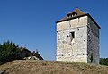
Donjon in the Roquefort castle grounds

Walibi Sud-Ouest amusement park

_-_Ch%C3%A2teau_-1.JPG)
