
Laplume
|
Laplume La Pluma |
||
|---|---|---|
.svg)
|
|
|
| region | Nouvelle-Aquitaine | |
| Department | Lot-et-Garonne | |
| Arrondissement | Agen | |
| Canton | L'Ouest Agenais | |
| Community association | Agen | |
| Coordinates | 44 ° 7 ' N , 0 ° 32' E | |
| height | 69-218 m | |
| surface | 32.64 km 2 | |
| Residents | 1,390 (January 1, 2017) | |
| Population density | 43 inhabitants / km 2 | |
| Post Code | 47310 | |
| INSEE code | 47137 | |
| Website | http://www.laplume.fr/ | |
 View of Laplume |
||

Laplume is a French commune with 1,390 inhabitants (as of January 1 2017) in the department of Lot-et-Garonne in the region Nouvelle-Aquitaine . The municipality belongs to the arrondissement of Agen and the canton of L'Ouest Agenais (until 2015: canton of Laplume ). The inhabitants are called Pennaviens .
geography
Laplume is located about twelve kilometers southwest of Agen in the Bruilhois . Laplume is surrounded by the neighboring communities Moncaut in the north and north-west, Sainte-Colombe-en-Bruilhois in the north, Roquefort in the north and north-east, Aubiac in the north-east, Moirax in the east and north-east, Marmont-Pachas in the east and south-east, Lamontjoie in the south, Saint-Vincent-de-Lamontjoie to the south and south-west and Saumont to the west.
The former route nationale 131 (today's D931) runs through the municipality .
Population development
| 1962 | 1968 | 1975 | 1982 | 1990 | 1999 | 2006 | 2013 |
|---|---|---|---|---|---|---|---|
| 1,248 | 1,078 | 1.101 | 1,081 | 1,042 | 1,205 | 1,327 | 1,446 |
| Source: Cassini and INSEE | |||||||
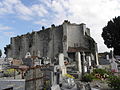
Attractions
- Saint-Barthélemy church, built between 1511 and 1525, monument historique since 2006
- Saint-Pierre church in Cazoux, built in the 12th century, remodeled in the 15th century, monument historique since 1925
- three wash houses
- earlier fortification

Saint Barthélemy Church
Saint-Pierre church

_%C3%89glise_Saint-Pierre-de-Cazeaux_06.JPG)