
Engayrac
| Engayrac | ||
|---|---|---|
|
||
| region | Nouvelle-Aquitaine | |
| Department | Lot-et-Garonne | |
| Arrondissement | Agen | |
| Canton | Le Pays de Serres | |
| Community association | Porte d'Aquitaine en Pays de Serres | |
| Coordinates | 44 ° 16 ' N , 0 ° 53' E | |
| height | 110-227 m | |
| surface | 10.03 km 2 | |
| Residents | 169 (January 1, 2017) | |
| Population density | 17 inhabitants / km 2 | |
| Post Code | 47470 | |
| INSEE code | 47087 | |

Engayrac is a municipality with 169 inhabitants (as of January 1 2017) in France in the department of Lot-et-Garonne in the region Nouvelle-Aquitaine (before 2016: Aquitaine ). Engayrac belongs to the Arrondissement of Agen and the canton of Le Pays de Serres (until 2015: canton of Beauville ). The inhabitants are called Engayracais .
geography
Engayrac is about 18 kilometers east-northeast of Agen . Engayrac is surrounded by the neighboring communities of Beauville in the north, Bourg-de-Visa in the east, Saint-Maurin in the south and Dondas in the south and west.
Population development
| 1962 | 1968 | 1975 | 1982 | 1990 | 1999 | 2006 | 2013 | |
|---|---|---|---|---|---|---|---|---|
| 196 | 171 | 165 | 171 | 163 | 158 | 150 | 149 | |
| Source: Cassini and INSEE | ||||||||
Attractions
- Saint-Pierre-aux-Liens church from the 12th century, Monument historique
- La Combebonnet castle from the 13th century with a chapel from the 15th / 16th century. century
- 12th century windmill and chapel in Campagnac

Saint-Pierre-aux-Liens church
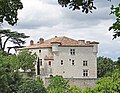
La Combebonnet Castle


Web links
Commons : Engayrac - collection of images, videos and audio files