
La Croix-Blanche
|
La Croix-Blanche La Crotz Blanca |
||
|---|---|---|

|
|
|
| region | Nouvelle-Aquitaine | |
| Department | Lot-et-Garonne | |
| Arrondissement | Agen | |
| Canton | Le Pays de Serres | |
| Community association | Grand Villeneuvois | |
| Coordinates | 44 ° 18 ′ N , 0 ° 42 ′ E | |
| height | 97-236 m | |
| surface | 13.05 km 2 | |
| Residents | 1,053 (January 1, 2017) | |
| Population density | 81 inhabitants / km 2 | |
| Post Code | 47340 | |
| INSEE code | 47075 | |
| Website | http://www.croixblanche47.fr/ | |
 Town hall (Mairie) of La Croix-Blanche |
||

La Croix-Blanche ( Occitan : La Blanca Crotz ) is a municipality with 1053 inhabitants (as of January 1 2017) in France in the department of Lot-et-Garonne in the region Nouvelle-Aquitaine (before 2016: Aquitaine ). la Croix-Blanche belongs to the Arrondissement Agen and the canton Le Pays de Serres (until 2015: Canton Laroque-Timbaut ). The inhabitants are called Cruciblanchais .
geography
La Croix-Blanche is about 17 kilometers northeast of Agen . La Croix-Blanche is surrounded by the neighboring communities of Castella in the north, Monbalen in the northeast, Laroque-Timbaut in the east, Bajamont in the south and Foulayronnes in the west and southwest.
Population development
| 1962 | 1968 | 1975 | 1982 | 1990 | 1999 | 2006 | 2013 | |
|---|---|---|---|---|---|---|---|---|
| 409 | 379 | 466 | 635 | 714 | 746 | 803 | 889 | |
| Source: Cassini and INSEE | ||||||||
Attractions
- Saint-Caprais church from the 12th century
- Fauguerolles keep

Saint-Caprais church
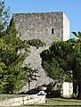
Fauguerolles keep


Web links
Commons : La Croix-Blanche - collection of images, videos and audio files