
Freudenberg (Baden)
| coat of arms | Germany map | |
|---|---|---|

|
Coordinates: 49 ° 45 ' N , 9 ° 20' E |
|
| Basic data | ||
| State : | Baden-Württemberg | |
| Administrative region : | Stuttgart | |
| County : | Main-Tauber district | |
| Height : | 133 m above sea level NHN | |
| Area : | 34.78 km 2 | |
| Residents: | 3774 (December 31, 2018) | |
| Population density : | 109 inhabitants per km 2 | |
| Postal code : | 97896 | |
| Primaries : | 09375, 09377, 09378 | |
| License plate : | TBB, MGH | |
| Community key : | 08 1 28 039 | |
| LOCODE : | DE FRH | |
City administration address : |
Hauptstrasse 152 97896 Freudenberg |
|
| Website : | ||
| Mayor : | Roger Henning | |
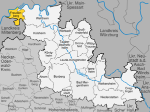
| Location of the city of Freudenberg in the Main-Tauber district | ||
  |
||


Freudenberg is a city on the Main and is located between Würzburg and Frankfurt in the Franconian northeast of Baden-Württemberg .
geography
.png)
City structure
The formerly independent communities Boxtal , Ebenheid , Rauenberg and Wessental belong to Freudenberg as districts .
![]() Map with all coordinates of the places in the city of Freudenberg: OSM
Map with all coordinates of the places in the city of Freudenberg: OSM
- The village of Boxtal ( ⊙ ), the Tremhof homestead ( ⊙ ) and the Sägmühlen residential area ( ⊙ ) belong to the former municipality of Boxtal .
- The village of Ebenheid ( ⊙ ) belongs to the former municipality of Ebenheid .
- The city of Freudenberg within the boundaries of December 31, 1971 includes the city of Freudenberg ( ⊙ ) and the Laukenhof ( ⊙ ) residential area as well as the abandoned villages of Lullenseit , Räuberschlößchen (also Alte Burg) and Teufelsburg.
- The former municipality Rauenberg include the village Rauenberg ( ⊙ ) that risen in Rauenberg village Schafhof (also winds) ( ⊙ ) and the living space Dürrhof with other forest home ( ⊙ ) and the Outbound village Glappenhausen.
- The village of Wessental ( ⊙ ) and the residential areas Antonius (Antons) -mühle ( ⊙ ) and Blankenmühle ( ⊙ ) belong to the former municipality of Wessental .
Protected areas
There are two landscape and two nature reserves in Freudenberg :
- Landscape protection area Wertheim : 3932.0 ha; Freudenberg, Külsheim, Werbach and Wertheim districts; since 1979.
- Freudenberg landscape protection area : 1,704.5 ha; Freudenberg and Wertheim districts; since 1984.
- Erlenwald nature reserve Röte-Strüt : 7.6 ha; Freudenberg community, Ebenheid district
- Nature reserve bird sanctuary at Tremhof : 46.5 ha; City of Freudenberg, Freudenberg district
The FFH area Sandstein Spessart is partly on the Freudenberg district. In addition, there are a total of 13 protected natural monuments in the area of the city of Freudenberg .
The Freudenberg / Bürgstadt water protection area designated by statutory ordinance of March 19, 1990 with WSG no. 128220 covers a protected area of 170.12 hectares.
Division of space

According to data from the State Statistical Office , as of 2014.
history
History of the city of Freudenberg


middle Ages
In 1159, Freudenberg was first mentioned in a document as Lüllenseit . Between 1160 and 1200 the prince-bishopric of Würzburg , to which the place belongs, built Frouwedenberch Castle , the name of which is carried over to the settlement. In 1287, Freudenberg was first mentioned in a document as a city ( castrum et civitas = castle and city ). On September 9, 1295, the Würzburg prince-bishop confirmed the enfeoffment of the castle and town to the Count of Wertheim . In 1333, Emperor Ludwig the Bavarian granted Gelnhausen town charter to Wertheim. This is linked to the right to hold a weekly market and to carry out the lower jurisdiction itself. In 1362 the city was also granted customs rights by Emperor Charles IV . Fourteen years later, the city was given high jurisdiction by the emperor. Ecclesiastically, Freudenberg belonged to the diocese of Mainz at that time , but secularly to the Würzburg monastery . In 1423 the city became the seat of the Freudenberg Office , which, in addition to the city itself, also included Ebenheid, Boxtal and two courtyards.
Modern times
After the death of the last Count of Wertheim in 1556, the fiefdom reverted to the Duchy of Würzburg. After the Counts of Stolberg were initially entrusted, the town and castle passed to the Löwenstein-Wertheim rulership in 1581 . At the turn of the 17th century, the witch hunt also hit Freudenberg: 150 residents of the city were burned as witches and wizards by 1632. In 1612 the city reverted to the Prince Diocese of Würzburg . It was in the Frankish Reichskreis .
As part of the mediatization , Freudenberg came to the County of Löwenstein-Wertheim-Freudenberg in 1803 . But as early as 1806 the city became Baden with the Rhine Federation Act. Initially still belonging to the lordly office of Löwenstein-Wertheim-Freudenberg , with its dissolution in 1813 the city came to the office of Wertheim , which was opened up in 1938 in the Tauberbischofsheim district . The district reform in 1973 will eventually lead to membership of the new Tauber district , which since 1974 Main-Tauber-Kreis is. 1935 Freudenberg loses the city charter , which is the place in 1956 awarded again. In 1938, the synagogue was destroyed during the Night of the Reichspogrom , with the parish clerk Anton Beck hiding the Torah scroll on the town hall granary. During the Second World War , the first Main Bridge and the iron footbridge at the lock were destroyed by German soldiers on the night from Good Friday to Holy Saturday 1945. The second Main Bridge was built in 1950. Freudenberg has been a state-approved resort since 1968.
Incorporations
- January 1, 1972: Boxtal, Ebenheid and Wessental
- December 31, 1972: Rauenberg
Freudenberg's districts and their history

 |
BoxtalBoxtal was first mentioned in 1181 as Bockeshol. In 1396 half of Boxtal was sold by the Lords of Riedern to the Counts of Wertheim . Since 1423 the village belonged to the Freudenberg office. In 1612 it fell with the entire office to the Prince Diocese of Würzburg and from then on shared the political and ecclesiastical fate of Freudenberg. In 1925 the Tremhof district was incorporated. One of the main attractions in Boxtal is probably the oldest German Lourdes Chapel - donated by Pastor Lorenz Englert. The chapel was consecrated on July 26, 1885. |

|
EbenheidEbenheid was first mentioned in a document in 1294 as Ebenothe. Since 1317 the Teutonic Order was the landlord; since 1423 the village belonged to the Freudenberg office. From 1545 the Counts of Wertheim were masters of Ebenheid. In 1612 the place fell to the Prince Diocese of Würzburg , with which it shared the history of Freudenberg from now on. |
 |
RauenbergIt is assumed that the hamlet of Wineden ("land won by clearing"), which was first mentioned in 1214, was the sub-settlement of the present-day town. Initially under various nobles (such as Konrad von Dürn and the Schenken von Prozelten), part of Wineden came into the hands of the Rüdt zu Collenberg (lords of the von Dürn family), namely the German master Konrad ( German Order ). This gave his brother Eberhard Rüdt von Collenberg on January 3, 1379 the village of Ruhenberg . At that time it was customary to dissolve or rename localities. In the 15th century Kurmainz took over the rule of Rauenberg, but it was still administered by the Rüdt as a fief. Also as Rauenberg since 15./16. Century had its own court and mayor, the Rüdt still signed as village lords. In 1576 Rauenberg belonged to the Miltenberg office and had twelve households. In 1635 Kurmainz moved into the fiefdom, as the male line of the Rüdt became extinct, and Rauenberg was subordinated to the Oberamt Miltenberg , from 1803 to the Amt Freudenberg. In 1813 the Freudenberg Office was dissolved and subordinated to the Wertheim Office, and thus Rauenberg was Baden for the first time. In 1925 the Dürrhof was incorporated. In 1936 Rauenberg was assigned to the Tauberbischofsheim district. In 1972 Rauenberg lost its independence and was merged with the city of Freudenberg. The landscape painter Franz Bronstert lived and worked partly in Rauenberg. |
 |
WessentalIn a document dated December 28, 1309, Wessental was first mentioned as Wezingenthal ( Valley of Wezicco ). |
Population development

The population of the city of Freudenberg (1961 and 1970 with the later incorporated towns) developed as follows:
| year | population |
|---|---|
| 1961 | 3560 |
| 1970 | 4011 |
| 1991 | 3943 |
| 1995 | 4124 |
| 2005 | 4030 |
| 2010 | 3904 |
| 2015 | 3800 |
| 2017 | 3756 |
Sources: Directory of municipalities and information from the State Statistical Office
City Archives
The archive of the city of Freudenberg was brought into the sub-archive of the Main-Tauber district in the Main-Tauber archive network . The archive network was set up in 1988 in the former hospital of the Bronnbach monastery under the auspices of the Wertheim State Archive, which was founded in 1978 .
religion
Christianity
The Reformation introduced in Freudenberg in 1525 lasted until 1612, when the city fell back to the Duchy of Würzburg . During the Thirty Years War , the city became Protestant for another two years from 1631 to 1633. In 1654 the city fell ecclesiastically from the diocese of Mainz to the diocese of Würzburg , to which it had been secularly for many centuries. After brief membership (since 1821) of the Speyer diocese , the Roman Catholic Christians of the Freudenberg pastoral care unit in the Tauberbischofsheim dean's office have been part of the Freiburg Archdiocese since 1827 .
Jewish community Freudenberg
There was a Jewish community in Freudenberg since the Middle Ages, which was wiped out during the persecution of Jews in 1298 . As early as 1442, Jews were mentioned again in the village. In the 16./17. In the 19th century, a modern Jewish community emerged in Freudenberg, which existed until the time of National Socialism. The Freudenberg Jewish community owned the Freudenberg synagogue , a religious school and a ritual bath .
politics
Municipal council
The parish council usually has 15 honorary members who are elected for five years. The municipal councils use the designation city council. The number of members can increase through compensating seats (total 2019: 16 seats; 2014: 19). In addition, the mayor acts as the municipal council chairman with voting rights.
The Unechte Teilorteschahl guarantees the districts a fixed number of seats: at least nine from the main town of Freudenberg, at least three from Boxtal and Rauenberg, at least two councils from Ebenheid and at least one council from Wessental.
The 2019 local elections led to the following result (in brackets: difference to 2014):
| Municipal Council 2019 | ||||
|---|---|---|---|---|
| Party / list | Share of votes | Seats | ||
| CDU | 65.1% (−4.0) | 13 (−1) | ||
| FW Freudenberg | 21.9% (+5.7) | 4 (+1) | ||
| SPD | 13.0% (−1.8) | 3 (± 0) | ||
| Turnout: 58.5% (+7.9) | ||||
mayor
Roger Henning was elected mayor in November 2014 with 54.5 percent of the vote.
See also: List of Mayors of the City of Freudenberg
Town twinning
- Saint-Arnoult-en-Yvelines , France, since May 4, 1994
coat of arms
The blazon of the coat of arms reads: “In a quartered shield; Field 1: In silver, a half, red armored and red-tongued black eagle at the gap; Field 2: A golden wave bar in blue; Field 3: In blue a six-petalled golden rose; Field 4: In silver, a rounded black triangle. "
Culture and sights
tourism
Swimming lake in the Seepark Freudenberg
In Seepark Freudenberg there is a publicly accessible swimming lake ( ⊙ ), which costs admission. The facility is open Monday to Thursday from 10 am to 7 pm, Friday to Sunday and during the school holidays from 9 am to 8 pm. There is a kiosk and a restaurant as well as sanitary facilities.

Tourist routes
Freudenberg is located on the Nibelungenstrasse , which leads past many sights.
Biking and hiking trails
Freudenberg is on the Main Cycle Route and the Liebliches Taubertal Cycle Route - the sporty one .
The eastern entrance to the Nibelungensteig , a 130-kilometer-long, certified long-distance hiking trail that runs through the Odenwald from west to east, is at Freudenberg Town Hall . The approximately 180 km long Jakobsweg Main-Taubertal leads through Freudenberg and Boxtal. The approximately 130 km long Taubertal Panorama Trail ends in the city. The Franconian Marienweg also runs through Freudenberg .
The first circular hiking trail in the Lieblichen Taubertal (LT 1) called "To the Heunensteinen" begins and ends in Freudenberg.
Buildings and monuments

Complete Freudenberg facility
The historic town center of Freudenberg available as a complete system since 2004 under monument protection.
Freudenberg Castle
The ruins of Freudenberg Castle rise above the town and date back to the late 12th century.
Churches and chapels
The oldest parts of the St. Laurentius cemetery chapel date from 1149. The Roman Catholic Old Laurentius Church was built in 1691/92. A new Laurentius Church was also consecrated to St. Lawrence of Rome in 1957 . The church in Boxtal is dedicated to St. Nicholas . The patron saint of the Rauenberg Church is St. Wendelinus . The church in Wessental is placed under the patronage Seven Sorrows of Mary in honor of Our Lady . The St. Leonhard is the patron of Ebenheid.
Transmitters
The transmitter Rauenberg , which is responsible for the supply of the places east of Rauenberg, serves the communication supply. The core city of Freudenberg is supplied by the Kirschfurt transmitter .
Recreation
A public bookcase and a Kneipp facility are located in the Maingarten on Freudenberger Main-Promenade. Another Kneipp facility is located in the Rauenberg district at the cemetery.
theatre
The Burgschauspielverein has been playing widely acclaimed open-air theater on the Freudenburg every odd year since 1987 .
societies
Many Freudenberg citizens are involved in over 70 associations. In addition to three sports clubs, three music clubs, two DLRG groups, four choirs and two church choirs, there are also non-everyday clubs in Freudenberg and its four districts, such as a castle theater club.
Economy and Infrastructure

traffic

Freudenberg is connected to the national rail network by the Miltenberg West – Wertheim railway line, with the Freudenberg-Kirschfurt stop , known as Freudenberg (Main) until 2008 , on the other side of the Main in Bavaria in the Kirschfurt district of the Collenberg community .
The town has had a road bridge over the Main since 1907. Freudenberg can be reached via the L 2310 ( main road ) and the L 2315 or St 2315 ( Main bridge ).
The Freudenberg shipping lock is at km 133.9 of the Main . The lock is 300 m long and 12 m wide. The height of fall is 4.51 m.
economy
The company headquarters of Rauch Möbelwerke has been in Freudenberg since it was founded in 1897, where 1,300 people are employed.
education
In Freudenberg there is the Lindtal School, a primary and technical secondary school , as well as the Eichwald primary school in Rauenberg and a municipal music school.
Personalities
Individual evidence
- ↑ State Statistical Office Baden-Württemberg - Population by nationality and gender on December 31, 2018 (CSV file) ( help on this ).
- ^ Main-Tauber-Kreis: Main-Tauber-Kreis: Cities and municipalities. Online at www.main-tauber-kreis.de, accessed on October 25, 2014
- ^ The state of Baden-Württemberg. Official description by district and municipality. Volume IV: Stuttgart district, Franconian and East Württemberg regional associations. Kohlhammer, Stuttgart 1980, ISBN 3-17-005708-1 . Pp. 315–318 and Laukenhof [living space ] at leo-bw.de
- ↑ Additional source on a place to live in Freudenberg: Schafhof (Winden) - place to live . Online at www.leo-bw.de. Retrieved January 12, 2019.
- ↑ Reinhard Wolf , Ulrike Kreh (ed.): The nature reserves in the Stuttgart administrative region . Thorbecke, Ostfildern 2007.
- ↑ State Statistical Office, area since 1988 according to actual use for Freudenberg.
- ↑ https://www.freudenberg-main.de/index.php?id=16 History of Freudenberg
- ^ City administration Freudenberg: core city Freudenberg am Main.
- ↑ a b c Federal Statistical Office (ed.): Historical municipality directory for the Federal Republic of Germany. Name, border and key number changes in municipalities, counties and administrative districts from May 27, 1970 to December 31, 1982 . W. Kohlhammer, Stuttgart / Mainz 1983, ISBN 3-17-003263-1 , p. 480 .
- ↑ Main-Tauber archive network - Bronnbach Monastery Cultural Office. In: kloster-bronnbach.de. Retrieved May 24, 2020 .
- ↑ Extended magazine inaugurated in the archive network. In: main-tauber-kreis.de. Retrieved May 24, 2020 .
- ^ State archive Wertheim - State archive Baden-Württemberg. In: landesarchiv-bw.de. Retrieved May 24, 2020 .
- ^ Alemannia Judaica: Freudenberg (Main-Tauber-Kreis) Jewish history / prayer hall / synagogue . Online at www.alemannia-judaica.de. Retrieved December 1, 2015.
- ^ City of Freudenberg: Main Statute, §3 ; accessed July 2, 2019.
- ^ City of Freudenberg: Main Statute, §14 ; accessed July 2, 2019.
- ^ State Statistical Office of Baden-Württemberg: Municipal elections 2019, City of Freudenberg ; City of Freudenberg: municipal council election 2019 ; FN-Web , May 26, 2019: Results of the 2019 municipal council elections in Freudenberg ; accessed July 2, 2019.
- ↑ Main-Post: Swimming lakes in Lower Franconia: special features and water quality . April 15, 2019. Online at www.mainpost.de. Retrieved September 30, 2019.
- ↑ "The Sportive" - Tourist Association Liebliches Taubertal. In: liebliches-taubertal.de. Retrieved August 3, 2020 .
- ↑ 2nd day stage - Freudenberg to Külsheim - Liebliches Taubertal tourist office. In: liebliches-taubertal.de. Retrieved August 3, 2020 .
- ↑ Jakobsweg Main-Taubertal (pilgrimage route) - wanderkompass.de. In: wanderkompass.de. Retrieved August 3, 2020 .
- ↑ Panoramaweg Taubertal - Tourist Association Liebliches Taubertal. In: liebliches-taubertal.de. Retrieved August 3, 2020 .
- ↑ Taubertal panorama hiking trail (long-distance hiking trail) - wanderkompass.de. In: wanderkompass.de. Retrieved August 3, 2020 .
- ↑ Circular hiking in the Taubertal. In: liebliches-taubertal.de. Retrieved May 17, 2020 .
- ↑ monuments Generic values plan for Möckmühl and Freudenberg . zum.de, March 31, 2008
- ↑ a b c d Super User: About the pastoral care unit. Retrieved June 26, 2017 (German).
- ↑ Radsüden: Regioradeln Liebliches Taubertal - Adventure tour 6 - Energy bike tour in the northern Taubertal ( page no longer available , search in web archives ) Info: The link was automatically marked as defective. Please check the link according to the instructions and then remove this notice. . Online at www.radsüden.de. Retrieved August 6, 2018.
- ↑ Lovely Taubertal: Water treading facilities . Online at www.liebliches-taubertal.de. Retrieved August 6, 2018.
- ^ Freudenberg am Main - Associations. Retrieved January 22, 2017 .
- ↑ Inland waterways of the Federal Republic of Germany, SECTION III: Inland waterways in the area of the Waterways and Shipping Directorate South ( Memento of the original from March 4, 2016 in the Internet Archive ) Info: The archive link was automatically inserted and not yet checked. Please check the original and archive link according to the instructions and then remove this notice. Retrieved July 31, 2010
- ^ IHK Baden-Württemberg: The largest companies in Baden-Württemberg, March 2013
Web links
- Freudenberg website
- To the archives of Boxtal, Ebenheid and Rauenberg in the Main-Tauber district archive
- Freudenberg on a website about “Baden” architecture

Maple | Assamstadt | Bad Mergentheim | Boxberg | Creglingen | Freudenberg | Large cattle field | Grünsfeld | Igersheim | Koenigheim | Külsheim | Lauda-Koenigshofen | Niederstetten | Tauberbischofsheim | Weikersheim | Werbach | Wertheim | Wittighausen
Boxtal | Ebenheid | Freudenberg City | Rauenberg with Dürrhof | Wessental with Blankenmühle