
Fouchy
| Fouchy | ||
|---|---|---|

|
|
|
| region | Grand Est | |
| Department | Bas-Rhin | |
| Arrondissement | Sélestat-Erstein | |
| Canton | Dirty | |
| Community association | Vallée de Villé | |
| Coordinates | 48 ° 20 ' N , 7 ° 16' E | |
| height | 292-831 m | |
| surface | 7.87 km 2 | |
| Residents | 656 (January 1, 2017) | |
| Population density | 83 inhabitants / km 2 | |
| Post Code | 67220 | |
| INSEE code | 67143 | |
 Mairie Fouchy |
||

Fouchy (German: Grube im Weilertal ) is a French commune with 656 inhabitants (as of January 1, 2017) in the Bas-Rhin department in the Grand Est region (until 2015 Alsace ). It belongs to the Arrondissement Sélestat-Erstein and the Canton of Mutzig .
geography
Fouchy is located in the Giessen Valley in the Vosges , about 16 kilometers northwest of Sélestat . In the south, the municipality extends to the border with the Haut-Rhin department . The Noirceux district belongs to Fouchy .
Neighboring communities of Fouchy are Bassemberg in the northeast, Breitenau in the east, Rombach-le-Franc in the south, Urbeis in the west and Lalaye in the northwest.
history
The village got its current name after the Thirty Years War .
Population development
| year | 1962 | 1968 | 1975 | 1982 | 1990 | 1999 | 2006 | 2017 |
| Residents | 533 | 486 | 458 | 482 | 509 | 568 | 597 | 656 |
Attractions
- Château de Weyersbourg, a castle first mentioned in 1793
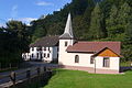
- St. John's Church ( Église Saint-Jean-Baptiste )
- Mariahilf Chapel ( Chapelle Notre-Dame-Auxiliatrice ) in the Noirceux district

Johanneskirche
Mariahilf Chapel


literature
- Le Patrimoine des Communes du Bas-Rhin. Flohic Editions, Volume 2, Charenton-le-Pont 1999, ISBN 2-84234-055-8 , pp. 1495-1497.
Web links
Commons : Fouchy - collection of images, videos and audio files