
Berghausen (Langenfeld)
|
Berghausen
City of Langenfeld (Rhineland)
Coordinates: 51 ° 6 ′ 47 " N , 6 ° 55 ′ 33" E
|
||
|---|---|---|
| Height : | 42 m above sea level NN | |
| Residents : | 5649 | |
Location of Berghausen in Langenfeld (Rhineland) |
||

Berghausen is situated in the northwest district of the city of Langenfeld (Rheinland) .
geography

Berghausen borders on Immigrath to the west and Langenfeld-Mitte to the north . In the east lies Richrath and in the west Monheim . Its northern border runs to Düsseldorf-Hellerhof and Düsseldorf-Garath .
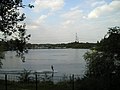
Berghausen is the second smallest district after Wiescheid , but with only 8.90 meters difference in altitude between the highest and lowest point, despite the name, it is not nearly as mountainous. Like large parts of Immigrath , Mittes and Reusrath, Berghausen is flat and characterized by agriculture. The Galkhauser Bach , which feeds its water to the Baumberg / Urdenbacher - Altrheinarm, should be mentioned in particular . Furthermore, in the western tip towards Baumberg, there are extensive groundwater lakes created by gravel , which today serve various leisure activities .
The municipalities of Wolfhagen , Fuhrkamp , Stefenshofen and Langfort also belong to the Berghausen district .
history
Prehistory and early history
Little research has been done on the prehistory and early history of the entire settlement area . An exception is the Rosendahlsberg in Reusrath , which has finds from the Paleolithic up to the year 360. Nevertheless, Berghausen itself has recently come up with an important archaeological find . It was made in January 2016 on the construction site west of Düsseldorfer Straße at the junction with An der Landstraße . Pieces of urns and shards, as well as bone fire , uncovered a previously unknown burial ground , the age of which is estimated at 2500 years. Researchers suspect the associated settlement to be in the immediate vicinity. This suggests that Berghausen was possibly settled for as long as Reusrath's south, since the two current districts of Langenfeld are on the same low and middle terrace to the right of the Rhine . They have also been directly connected to each other for at least a thousand years by today's B 8 , so that there will not only have been continuous visits from travelers since the Bronze Age , Iron Age ( Hallstatt and La Tène times ). In any case, for the south of Langenfeld, continuous settlement is undisputed thanks to archaeological evidence for the aforementioned period since the 1950s.
There is then disagreement about the further development: Some historians assume that Celtic tribes living here will move away at the beginning of the first century and want to assume a new settlement for the second century after Christ. Others see the end of the occupation until the third and fourth centuries, because from this point on for several hundred years no archaeological finds can be detected more (at least those which would be assigned a settlement). From Roman records , however, it is known that the Romans from their forts out expeditions took to the right of the Rhine, Germanic settlement area. Such an action is reported for the year 388, which was brought to a standstill with poisoned arrows in front of Franconian forests . Noting in the margin, this gave rise to the assumption that the site of such a battle on the Bone Mountain in Immigrath was assumed, because Roman urn graves have been brought to light there. It is also known for the period between 511 and 532 that the Merovingian Prince Theudebert I had to repel an incursion by the Danes into the right bank of the Rhine. However, due to a lack of evidence, it is unknown whether there were Merovingians living here permanently at the time. In any case, the resettlement of Richrath can be assumed to be in the year 796 thanks to a dated bone find under today's St. Martin's Church .
Be that as it may, according to the currently prevailing doctrine, a gradual departure of Germanic tribes living here - possibly actually after Roman war campaigns - with even a temporary depopulation of this area can (and should here) be assumed. However, this assumption of historical research contradicts the name research , which was carried out for places like Beeren -broich, Bräu -haus, Bur -bach, Gar -küche, Glad -bach, Hucklen -bruch, Krüders -heide, Mehl -bruch, Meisen -tal ( near Mautpfad, Immigrath), Merx , Reus -rath, Rich -rath, Schnepp -rath and Virne -burg claims to have discovered remnants from Celtic times in the first components. Because if this assumption were correct, it would corroborate the thesis that Germanic Sugambrians would have moved up for Celts who emigrated to the Roman Empire as early as the second century AD . According to the further assumption, these might have taken over their place names and combined them with their own descriptions. All these considerations are of little help, however, without archaeological evidence they remain just as speculation as a Merovingian settlement in Richrath in the 5th and 6th centuries suspected on the basis of broken fragments.
Middle Ages and Modern Times
Whether settled or not, the first documentary evidence can be found for Berghausen for the years 1218/1231, namely “Berchusen” for Berghausen and perhaps the Celtic “Mergse” for Merx. In 1278 the “Stailshoff” (Staelshof) is called, 1279 “Lancwade” (Languist, Langfort), 1299 the “hoff zo dem Eygen” (Eigenhof, Berghausen), 1367 “Wolfhain” (Wolfhagen) and 1449 “Soilpoil” (Solpert ). In the Middle Ages, Berghausen belonged to the parish of Richrath, and later to the Richrath rule. The troop movements during the Thirty Years 'War , the Seven Years' War and Napoleon's train with 80,000 soldiers through the village, after 3,600 French had advanced across the Rhine to Langfort on October 11, 1795, were decisive . During the First World War the village suffered from the absence of young men, 27 of whom did not return either. The Second World War came to an end for Berghausen with the invasion of the Americans on April 15, 1945.
About the name Berghausen
As already mentioned, the difference in altitude between the lowest and highest point in Berghausen is just 8.90 meters. Sometimes the syllable mountain is therefore understood in the sense of belonging to the Duchy of Berg . Others interpret mountain in the sense of security . Still others link the mountain with the barely perceptible, minimal elevation on which the aldi camp can be found today. And last but not least, a connection to the legendary figure Berchta ( Frau Holle ) is brought into play with regard to the street "Im Schneeloch", following on from a possibly continuous settlement since the Celtic times . The place names quoted above - possibly of Celtic origin - may have been the inspiration here. Nevertheless, the interpretation should be understood as a joke. Ultimately, the origin of the name will probably no longer be clear. In any case, the presumption in favor of the terrain formation represents the currently prevailing opinion.
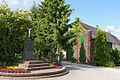
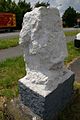
Brandshof monument in Berghausen
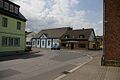
opposite: restaurant zur Krone and billiard café
Picturesque corner: In the courtyards
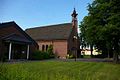
St Paul in Berghausen, inaugurated in 1926


Spotlight: building history
Berghausen has some quiet spots , away from the thoroughfares , in which it has kept its village character . The street "In den Höfe" with the wayside cross (built in 1930) is only mentioned here as an example. There are also some historical buildings in Berghausen that would like to be briefly presented here:
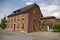
Old post office
The first post office in Langenfeld was set up in the Langenfeld house between 1774 and 1788 . However, the first post holder offered travelers the option of having a meal , which extended the travel time of the stagecoaches . After the post office became a disadvantage in the eyes of the Thurn und Taxis family , it was initially moved back to Opladen , but on October 11, 1793, until the post office lines were closed in 1905, it finally came to the intersection of Via Publica , also known as Cologne-Arnheimer Chaussee known, with the provincial road Elberfeld-Hitdorf . The latter connected the Hitdorf Rhine port with the Bergisches Land . The course of this street is formed by today's "Hauptstraße", the former B 229 , as well as the B 229, "Solinger Straße" from the town hall, which is still in the range of a federal road . The Langenfeld house, however, today's Alte Post , was once called the Probsthof and is located opposite the Zum Weißenstein inn on today's B 8, here called "Düsseldorfer Straße". In the opinion of Fritz Hinrichs , the Probsthof already existed around 1250 and was once surrounded by an earth wall and moat . The establishment of the state riding and driving school for the training of young coach drivers and the relocation of the mail distribution center from Düsseldorf to Langenfeld-Fuhrkamp (belonging to Berghausen) appear to be a logical consequence. Correction: The last stagecoach trip in 1905 ended at the 3rd post station on the corner of Bahnhofstrasse / Poststrasse at the now plastered bay window. Presumably, with the commissioning of the Monheim "Langenfeld" train station in 1845, the second post office from 1793 was given up in favor of the building (with bay window) closer to the train station, as travelers and letters came by train. In 1905, years later, one more "last stagecoach ride" was undertaken up to this point. The "Hotel zur Post" at Langenfeld train station also indicates this location.

Stagecoach in Remise at the City Museum

Van, Remise Stadtmuseum L'feld

Remise for stagecoaches at the Stadtmuseum L'feld

Path hour marker at the Langenfeld City Museum


The story of the notorious robber Mathias Weber , who was executed just two days before the execution of Schinderhannes on February 19, 1803 in Cologne for his actions, belongs to the era of the stagecoach . The Fetzer , as he was called, attacked the Probsthaus, the old post office , with several cronies on October 28, 1799 , shot out the lamp, tied up and gagged the two postilions . Then the baggage car loaded with money (see picture above) was broken into and its contents looted. In the course of action then stepped innkeeper because of the noise even in the taproom , there were shots again, but the host was hurt only by blunt force to the head and robbed of his valuables. In total, the robbers were able to steal a sum of 50,000 livres, about 13,471 Reichstaler, according to today's understanding about 1 million EUR. It became known from the escape that the robbers first divided their prey before the probably adventurous crossing in a small boat across the Rhine .
Good Langfort
Gut Langfort possibly goes back to a former tower hill castle, also called motte in castle research. Such castles were owned by the local nobility , who had these fortifications built to protect their belongings from attacks. In the Middle Ages, Langfort was called Langwit or Langwaden , which can be traced back to tied long wicker bundles of twigs that were spread out in the swampy terrain for the foundation in order to build structures on it with earth and wood. In addition, the name components -waden , also -widen , which means to bind in Old High German , indicate witu on wood , forest and bandage , which can also be understood in the direction of wickerwork bundles. In fact, in 1968, in the immediate vicinity of Gut Langfort, for example between the AWO home for the elderly and the swimming pool , such bundles of wickerwork were discovered during house construction work, but were not investigated further.
Today the presumption of a medieval hilltop castle about 500 meters away on the Galkhauser Bach as the predecessor of the knight's seat first mentioned in writing in 1279 is the prevailing opinion. The property was owned by the nobility until 1804, most recently by the von Velbrück family . 1870 Baroness acquired from Eppinghoven for their sons George and Arthur, extramarital offspring with the Belgian King Leopold I , the good. The agricultural use of the building dates back to the year 1913. The estate was also due to construction of the 1922/23 manor Langfort with construction of the clock tower (with Big Ben - Glockenspiel ) expanded. After it had been used as an experimental farm for seed and seed cultivation from 1936 , it became the property of the city of Düsseldorf in 1961 and the city of Langenfeld in 1981. In the 1970s, the use of equestrian sport finally began , in August 2001 the state riding and driving school Rhineland was established. The estate has been recognized as a listed building by the Environmental Protection and Beautification Association since 2004.
St. Paul Church
Around 1880, the desire for an own church in Berghausen first arose. But it was not until December 19, 1926 that the solemn inauguration of St. Paul could be celebrated.
The fire yard
The main building of the Brandshof was built in 1823 as a two-storey residential building with ashlar walls and a half-hip roof. It is a testament to house building , as it was common in the 19th century in the Bergisches Land . At the turn of the 20th century, the court was the seat of the Freiherrlich-von-Eppinghof estate administration . After changing owners, the farm has been under the same management for around forty years. In front of the courtyard and in the direction of the war memorial (formerly the location of the Gasthof Zur Linde ), the Schürreskarren -Rennen of the Kirmesjonge Berghausen 1929 eV has been taking place on the second weekend in September . The starting point is here, opposite the Gasthof Zur Krone . The participants in the races in the various categories ( Kettcar , Juniors and Seniors - Schürreskarren) are listed here.

Gut Langfort in Berghausen

Langfort amusement park
The Weißenstein in Berghausen

Restaurant Zum Weißenstein


Berghausen water tower
The water tower Berghausen on the road on slate base is evidenced by a monument - report a get value from artistic, scientific and urban planning building. It was therefore placed under monument protection in May 2005.
The legend of the Weißenstein
The building of today's restaurant Am Weißenstein was erected in 1906 instead of a previous building, of which there are no more pictures . It is assumed, however, that the customs post was once located here, which was moved here from Richrath ( customs house ) after the Thirty Years War . The building of the restaurant is located a little to the south on the B 8 opposite the former Probsthof , the old post office . Immediately north of the B 8 next to the inn is the Weißenstein . From 1927 onwards the first races of the funfair jonge for the Blue Ribbon took place here as " sand track races ". Then it went on for years in the Treibstrasse in front of St. Paulus. Eventually the venue changed to Baumberger Straße .
There is a legend about the Weißenstein itself that one day the advance of an army from the east will be stopped there. Light in this nebulous prophecy brings possibly another tradition from Rheinmühlheim ( Cologne-Mülheim ): There, the forecast issue in the nation that probably the Turks down to the Rhine valley , would the town, easy access. The decisive battle was fought there, in which the German emperor, riding a white horse, was to kill the Turkish sultan and drive his army into the Rhine . A horse burial from "Götscher Weg", discovered during canal construction work in the 1960s, as well as Turkish sabers , kept at Castle Castle , gave rise to the assumption that a true story could actually have entered the world of legends here. According to information from fellow Turkish citizens, there was in Turkish history books the death of the leader of an advance detachment somewhere in the Rhineland . Unfortunately, a request via the Turkish consulate was unsuccessful.
school
In 1870 the Catholic primary school Treibstrasse , which has also been called the Paulus School since 1994 , was established in Berghausen . It has already had to be expanded several times due to population growth . In 1987, for example, two new classrooms were inaugurated on the Treibstrasse. The gym of the school , after one of the sport earned Berghausener Walter Reiffers hall is welcomed, was handed over to their destination in the 1975th
population
The number of inhabitants in Berghausen as of December 31st was:
- 2005 - 5649
- 2006 - 5728
- 2007 - 5772
Club life
- MGV Philomele Berghausen, a male choir founded in 1880
- Church choir St. Cäcilia
- Kimesjonge Berhausen 1929 e. V.
- SSV Berghausen 1968 e. V.
Economy and Transport
The next junction is "Langenfeld-Richrath" on the A 59 .

Place of the SSV Berghausen
4-lane water ski facility, Berghausen


S-Bahn stop

The Langenfeld-Berghausen S-Bahn station is about 16 kilometers south of Düsseldorf Central Station . It is located on the Cologne – Duisburg railway line and belongs to station category 5.
The train station is in the east of the Langenfeld-Berghausen district. It is located below Berghausener Strasse. It has a central platform with two entrances to Berghausener Str. The station is currently served by two S-Bahn lines and two bus lines.
Individual evidence
- ↑ a b c d e f g h i j Rolf Müller, " Stadtgeschichte Langenfeld Rheinland ", Verlag Stadtarchiv Langenfeld 1992
- ^ Stephan Meisel: " Sensational find on the construction site. " Rheinische Post, January 30, 2015.
- ↑ a b c d e f g h i Rudy Schörmann, " Langenfeld-Berghausen - In the past, yesterday, today ", Buchhandlung Bukowski, Langenfeld 2000
- ↑ Eugen Ewig, " The Merovingians and the Franconian Empire ", Stuttgart 1988, p. 71.
- ↑ Claus-Peter Peters, " Langenfeld im Wandel der Zeiten ", Langenfeld 2013, p. 13.
- ↑ Stephan Meisel: " Already in the 8th century. " Rheinische Post, June 26, 2004.
- ↑ Claus-Peter Peters, " Langenfeld im Wandel der Zeiten ", Langenfeld 2013, p. 71.
- ↑ Berghausen - Where is the mountain? . ritter-pitter.de. Retrieved September 14, 2014.
- ↑ a b c Friedhelm Görgens, Langenfeld , Droste, Düsseldorf 1984
- ^ A b Environmental Protection and Beautification Association Langenfeld eV, A guide through the built history of Langenfeld
- ↑ Station category list 2016 , Deutsche Bahn, PDF 0.33 MB, accessed on February 26, 2016
literature
- Rolf Müller, Stadtgeschichte Langenfeld, Verlag Stadtarchiv Langenfeld 1992
- Friedhelm Görgens, Langenfeld, Droste, Düsseldorf 1984
- Rudy Schörmann, Langenfeld-Berghausen, then, yesterday, today, Buchhandlung von Bukowski, Langenfeld 2000
- Environmental Protection and Beautification Association Langenfeld eV, A guide through the built history of Langenfeld
Districts: Langenfeld-Mitte | Immigrath | Richrath | Reusrath | Berghausen | Wiescheid
Locations and locations: Alt-Langenfeld | Brewhouse | Brandshof | Dückeburg | Feldhausen | Flachenhof | Fuhrkamp | Furth | Galkhausen | Ganspohl | Gieslenberg | Gladbach | Götsche | Götscher mill | Gravenberg | Hail cross | Hapelrath | Hardt | Hausingen | Hedge | Heinenbusch | Hoemann | Hucklenbruch | Hüsgen | Kämpe | Kaisersbusch | Limestone hedge | Katzberg | Cherry tree | Köttingen | Krüdersheide | Landwehr | Langfort | Corn flour | Neuburger Hof | Neurath | Ossenbruch | Rietherbach | Riethrather Hof | Riethrath Mill | Schelthoven | Schnepprath | Schwanenmühle | South | Stone rush | Stefenshofen | Turret | Virneburg | Wafert | Weißenstein | Widdauen | Angle | Wolfhagen | Customs House