Habère-Poche
| Habère-Poche | ||
|---|---|---|
|
|
||
| region | Auvergne-Rhône-Alpes | |
| Department | Haute-Savoie | |
| Arrondissement | Thonon-les-Bains | |
| Canton | Sciez | |
| Community association | Vallée Verte | |
| Coordinates | 46 ° 15 ′ N , 6 ° 28 ′ E | |
| height | 850-1,560 m | |
| surface | 11.96 km 2 | |
| Residents | 1,465 (January 1, 2017) | |
| Population density | 122 inhabitants / km 2 | |
| Post Code | 74420 | |
| INSEE code | 74140 | |
| Website | www.habere-poche.fr | |
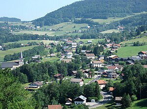
 View of Habère-Poche |
||
Habère-Poche is a French commune in the department of Haute-Savoie in the region of Auvergne Rhône-Alpes .
geography
Habère-Poche is at 950 m , about 25 kilometers east of the city of Geneva (as the crow flies). The village extends on a slope exposed to the west in the valley of the Vallée Verte, at the northwest foot of the Montagne d'Hirmentaz, in the northwestern Savoy Alps .
The area of the 11.96 km² municipal area includes the uppermost section of the Vallée Verte. The open valley extends in a northeast-southwest direction and is drained by the Menoge with its source streams to the Arve . The basin is surrounded on three sides by mountain peaks: to the west by the Pointe de Targaillan ( 1237 m ) and the Crêt Vernay ( 1220 m ), in between the Col de Cou, to the north by Mont Forchat ( 1539 m ), flanked by the pass crossings Col des Moises and Col des Arces, as well as in the east from the heights around the Col du Terramont. On the Montagne d'Hirmentaz in the southeast, the highest point of Habère-Poche is reached at 1596 m .
Community structure
In addition to the actual village center, Habère-Poche also includes various hamlet settlements, including:
- Reculfou ( 895 m ) at the southern foot of the Pointe de Targaillan
- Chez Prachex ( 924 m ) at the eastern foot of the Pointe de Targaillan
- Les Crottes ( 1000 m ) at the east foot of the Pointe de Targaillan
- Argence ( 1025 m ) below the Col de Cou
- La Covasserie ( 975 m ) on the northern edge of the village
- Le Vernay ( 1000 m ) on the ascent to the Col des Arces
- Doucy ( 1040 m ) at the foot of Mont Forchat
- Ramble ( 1058 m ) at the foot of Mont Forchat
Neighboring communities of Habère-Poche are Draillant in the north, Lullin and Bellevaux in the east, Habère-Lullin in the south and Cervens in the west.
history
The area around Habère-Poche was reclaimed in the Middle Ages by the monks of the Abbey of Saint-Jean-d'Aulps . By the end of the 18th century, Habère-Poche and Habère-Lullin formed a single municipality called Les Habères. With the canton of Boëge, Habère-Poche moved from the Arrondissement of Bonneville to the Arrondissement of Thonon-les-Bains in 1939 .
Attractions
The village church of Habère-Poche dates from the 19th century.
population
| Population development | |
|---|---|
| year | Residents |
| 1962 | 435 |
| 1968 | 452 |
| 1975 | 464 |
| 1982 | 511 |
| 1990 | 662 |
| 1999 | 729 |
With 1,465 inhabitants (as of January 1, 2017), Habère-Poche is one of the small communities in the Haute-Savoie department. Since the mid-1970s, thanks to the beautiful residential area, there has been continuous strong growth in the number of residents. Numerous single-family houses were built outside the old town center.
Economy and Infrastructure
Habère-Poche was a village dominated by agriculture and forestry well into the 20th century . Today there are various local small businesses. Some employees are commuters who work in the larger towns in the area, especially in the Geneva-Annemasse area and in Thonon-les-Bains. The Montagne d'Hirmentaz has developed into a winter sports area in recent decades. The slopes are accessed by mountain railways and ski lifts. In addition, a glider airfield, varied mountain bike routes and extensive hiking trails enable further activities.
The village is located on the connecting road that leads from Thonon-les-Bains over the Col de Cou to Fillinges in the Arve Valley. Further connections exist with Bellevaux and Lullin.

