Le Biot
| Le Biot | ||
|---|---|---|

|
|
|
| region | Auvergne-Rhône-Alpes | |
| Department | Haute-Savoie | |
| Arrondissement | Thonon-les-Bains | |
| Canton | Evian-les-Bains | |
| Community association | Skin chablais | |
| Coordinates | 46 ° 16 ' N , 6 ° 38' E | |
| height | 660-1,870 m | |
| surface | 13.18 km 2 | |
| Residents | 572 (January 1, 2017) | |
| Population density | 43 inhabitants / km 2 | |
| Post Code | 74430 | |
| INSEE code | 74034 | |
| Website | www.le-biot.com | |
 Le Biot |
||
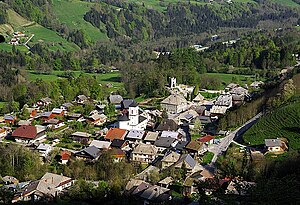
Le Biot is a French commune in the department of Haute-Savoie in the region of Auvergne Rhône-Alpes . It belongs to the canton of Évian-les-Bains in the Arrondissement of Thonon-les-Bains .
geography
Le Biot is located at 831 m , 17 kilometers southeast of the town of Thonon-les-Bains (as the crow flies). The former mountain village extends in central Chablais , on the debris cone of the Dorfbach on the eastern slope of the Dranse de Morzine , at the western foot of the Pointe de Cercle in the northern Savoy Alps .
The area of the 13.18 km² municipal area includes a section of the Vallée d'Aulps. The western border is the Dranse de Morzine, which runs from south to north in a deeply cut valley here. From this course of the river, the municipality extends east over the slope to the crest of the mountain range that separates the Vallée d'Aulps from the Vallée d'Abondance. Striking mountain peaks are the Mont Ouzon (at 1881 m, the highest elevation of Le Biot), the Pointe du Mont ( 1617 m ) and the Pointe de Cercle ( 1808 m ). In between is the Col du Corbier pass, which creates a connection with the Vallée d'Abondance that has been used since ancient times.
Le Biot includes the hamlet settlements of Gys ( 690 m ) and La Touvière ( 740 m ) in the valley floor of the Vallée d'Aulps, Le Corbier ( 1080 m ) on the ascent to Col du Corbier and the winter sports village of Drouzin-Le Mont ( 1237 m ) the top of the Col du Corbier. Neighboring municipalities of Le Biot are La Baume in the north, Bonnevaux and Abondance in the east, Saint-Jean-d'Aulps in the south and Seytroux in the west.
history
The place name is derived from the patois expression biola (birch). Le Biot is the oldest village in the Vallée d'Aulps. A church was built here as early as the 8th or 9th century. The municipality of Biot used to include all the villages in the Vallée d'Aulps north of the narrow point of the Défilé des Tines. In the course of the 18th and 19th centuries, however, these localities were elevated to independent municipalities.
Attractions
The village church was built from 1846 to 1850 in the neoclassical style. There are ruins of an old bell tower in the cemetery. Chapels are in the hamlets of Gys and Le Corbier.
population
| Population development | |
|---|---|
| year | Residents |
| 1962 | 279 |
| 1968 | 231 |
| 1975 | 215 |
| 1982 | 286 |
| 1990 | 333 |
| 1999 | 340 |
| 2005 | 424 |
With 572 inhabitants (as of January 1, 2017), Le Biot is one of the small communities in the Haute-Savoie department. After the number of inhabitants had decreased significantly in the course of the 20th century (Le Biot had 615 inhabitants in 1901), a population increase has been recorded again since the mid-1970s. Numerous single-family houses were built outside the old town center.
Economy and Infrastructure
Until well into the 20th century, Le Biot was a predominantly agricultural village. In the meantime, a winter sports station with various tourist facilities has developed on the Col du Corbier. Many workers are commuters who go to work in the larger towns in the area, especially in Thonon-les-Bains.
The village is off the main thoroughfares, but is relatively easy to reach from the main road from Thonon-les-Bains to Morzine . Another road connection is via the Col du Corbier with Bonnevaux in the Vallée d'Abondance.
Personalities
- Robert Coffy (1920–1995), Archbishop of Marseille
