
Henneberger Land

Henneberger Land is the cultural-historical landscape name for large parts of southern Thuringia , which correspond to the heartland of the territory of the former county of Henneberg . The name is not in use in the district of Sonneberg , which, like the rest of the eastern half of the Coburg region, was only briefly, albeit a culturally influential, part of the Henneberger's sphere of influence and therefore belongs to the Coburg region. Ethnically, culturally and linguistically, this region is part of the Franconia region, which is divided into Bavaria , Thuringia , Baden-Württemberg and, to a lesser extent, Hesse .
Definitions and Limits


The Henneberger Land is located in southern Thuringia between the Rhön in the west , the slate mountains in the east , the Thuringian Forest in the north and - beyond today's Thuringian state borders - the Grabfeld in the south . Today, on the Thuringian side, this area corresponds to the districts of Schmalkalden-Meiningen and Hildburghausen located south of the Rennsteig , the independent city of Suhl and the former Bad Salzungen district in the south of the Wartburg district and the parts of the Ilm district located south of the Rennsteige .
While this description largely coincides with the region of southern Thuringia (excluding the district of Sonneberg), today the name Henneberger Land is often only used for the area characterized by the Henneberg dialect, which is made up of today's district of Schmalkalden-Meiningen , the northwest of the district of Hildburghausen ( Schleusingen , Themar ) and the independent city of Suhl . This region owes its name to the historic county of Henneberg , which existed from the 11th century to 1583 and whose successor states continued to form a common voice in the Franconian Empire under this name until 1806 . In the name Henneberger Land , as in many comparable cases, the name of the ruling dynasty that dominated over a long period of time lives on as a landscape designation.
characterization
The legend of the Henneberg:

A gentleman of a noble family moved to Germany, looking for peace and a comfortable place to build; there he came to a place in Franconia and found a mountain in the country that pleased him. As he rode to look at him, a black hen that had young flew in front of him; He took it for his coat of arms and named the mountain Hennenberg and built a beautiful castle on it, as can still be seen; and on the mountain there was a kernel (turn where you turn the plow?), there he even built his servants a merry dwelling and named them von der körre.
Henneberg lies between the Franconian towns of Meiningen in the Free State of Thuringia and Mellrichstadt in the Free State of Bavaria . At the foot of the mountain there is the town of the same name, Henneberg , and on the mountain is Henneberg Castle . It was the ancestral seat of the Counts of Henneberg and ultimately the namesake of the entire region. Visible far into the country, it is still an important symbol of this country and its time. Due to its location between Franconia , Hesse and Thuringia , the Henneberger Land was politically, culturally, economically and finally also militarily in a contested mixed zone. This is also reflected in the languages encountered here, which underline Henneberg's role as a mediator and bridge between the three major regions. This development has resulted in an identity that is intensely Franconian, Hessian in the West and, in general, Thuringian in particular , and in which very unique facets emerged. The historic Franconia , divided between Bavaria , Hesse, Baden-Württemberg and Thuringia, makes up the main area in the Henneberger Land , which also has Bavarian and Hessian shares beyond the state borders.
Hardly any other region of Thuringia has been so marked by the breakup of the rulers and the change in the balance of power as the Henneberger Land, which inevitably led to the loss of identity and a sense of belonging. The culmination of this development was the creation of the Suhl district in the GDR, which for the first time in centuries reunited large parts of the Henneberger Land into one administrative unit, but in which the Henneberg-Franconian identity faded into the background (in the Sonneberg district this identity formation took place in 1952 the beginning of the lowering of the town of Suhl, which was less populous and less important at the time, and the strong historical relationships in the Itzgründisch-Coburg area are much less common). So it came about that outside of the Henneberg heartland around Suhl and Schleusingen the designation "Henneberger Land" was or is only rarely in use. This condition has been preserved to this day, as the parish of the Evangelical Church "Henneberger Land" , for example, only unites the areas around Suhl and Schleusingen that once fell to Prussia under the umbrella of the Evangelical Church in Central Germany . Since the fall of the Berlin Wall in 1989 and at the latest the 900th anniversary of the Henneberger Land in 1996, the term has been used a little more frequently again.
Under the sign of the hen

Seal (privet) of Berthold V. von Henneberg

Family coat of arms according to Scheibler's book of arms
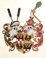
Coat of arms of the princes of Henneberg and the Burgraviate of Würzburg


In today's southern Thuringia and large parts of Lower Franconia, many local and district coats of arms still refer to the former rulers and ultimately the relationship to the Henneberger Land cultural landscape .

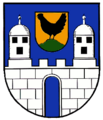
District of Sonneberg , district coat of arms from 1920 to 1952


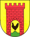
In southern Thuringia , in the heart of the historic county of Henneberg, these are the coats of arms of Albrechts , Behrungen , Benshausen , Bettenhausen , Dietzhausen , Ebertshausen , Grabfeld , Goldlauter , Heinrichs , Henneberg , Jüchsen , Kühndorf , Marisfeld , Meiningen , Ober Maßfeld-Grimmenthal , Oberweid , Rentwertshausen , Rohr , Schleusingen , Schmalkalden , Schmiedefeld am Rennsteig , Schwarza , Suhl , Sülzfeld , Themar , Untermaßfeld , Waldau , Wasungen and Wolfmannshausen .

Coat of arms of the independent city of Suhl


Coat of arms of the city of Meiningen

Coat of arms of the city of Schleusingen

Coat of arms of the city of Schmalkalden

Themar city coat of arms
Coat of arms of the city of Wasungen


In the Sonneberger Land in southern Thuringia , the coat of arms of Mengersgereuth-Hammern , in today's Wartburg district the coat of arms of Kaltennordheim and north of the Rennsteig and thus, strictly speaking outside of southern Thuringia proper, the coats of arms of Ilmenau , Heyda , Oberpörlitz and Neusiß, refer to the Henneberg past.

Coat of arms of the city of Ilmenau
Coat of arms of the city of Kaltennordheim


In Lower Franconia these are the coats of arms of Aschach , Bad Bocklet , Dittelbrunn , Schonungen , Üchtelhausen and Willmars .
History and settlement
Prehistoric times to approx. 1000 BC Chr.
Archaeological finds suggest that the first hunters and gatherers settled in what is now southern Thuringia as early as 80,000–10,000 years ago, during the last Ice Age. Around 5000–2000 BC Chr. Neolithic and Bronze Age artefacts of the so-called band or cord ceramics and bell-cup people, in the Gleichberg area, reveal increasingly structured settlement cultures with agriculture and cattle breeding. Barrows around 1600–1200 BC prove a pronounced cult of the dead of the culture that settled here. Between Wichtshausen and Schwarza as well as in the Rhön . In the Gleichberg area originated about 1000 BC. First fortifications. Finds of the so-called urn field culture in the Grabfeld, Werratal, in the Vorderrhön and near Gumpelstadt near Schweina also refer to this time.
Iron Age up to the 6th century
During the Iron Age Hallstadt period around 700–450 BC. A second settlement of the Steinsburg near Römhild took place. Archaeological excavations in the Grabfeld, Jüchsen, Henfstädt and Herpf show up to approx. 50 BC Among other things, Celtic settlements from the La Tène period. From the 1st to the 6th century AD, the first Germanic tribes of the Alemanni, Hermunduren and Thuringians began to spread to this area. Stronger settlement associations emerged on the fertile river meadows of the Werra very early on. The towns with the name endings -ingen and -ungen such. B. Salzungen, Breitungen, Schwallungen, Wasungen and opinions (later Meiningen) go back to the Alemanni, who settled this area on their move south from the northwest in the 5th and 6th centuries.
The Frankish colonization in the east 7. – 10. century
In the 7th century the Frankish colonization in the east began, which lasted until the early 9th century and promoted medieval land development and the creation of feudal structures. With the Frankish settlement, Christian missionary work began under Bonifatius and Kilian, starting from the religious centers of Bamberg, Würzburg, the monasteries of Fulda and Hersfeld, which immediately integrated the territory into their sphere of influence. The limit of the Franconian settlement is essentially marked by the Rennsteig . In the Salzungen and Nordrhön area, between Salzbogen and Rennsteig, a Franconian-Thuringian mixed zone was created. This small transition area made it difficult for the Franconians to take over the land due to the existing salt springs and so the Franks were only able to establish new settlements in isolated cases. The dialect spoken here suggests a main settlement from the west or north-west, and from today's point of view it would be more likely to be described as an East Franconian-East Hessian-Thuringian mixed zone, whereby the Hessian is very characteristic.
After the Thuringian Empire was defeated by the Franks in 531, this region was also included in a system of fortified Franconian royal courts on the Werra and later part of the Grand Duchy of Franconia under Charlemagne. 758, when Jüchsen was first mentioned in a document, written records begin, mainly from the Fulda monastery, which is rich in land here. Around 815 to 824, with the foundation of the Rohr monastery, one of the first religious centers emerged in northernmost Franconia.
The heyday of the Henneberger from the 11th century
With the decline of the Franconian county constitution in the 10th and 11th centuries, the disintegration of the Franconian empire began and a number of petty lords emerged. The first written mention of the Counts of Henneberg, who unite the region as a central territorial power, dates back to 1096. Under their influence, small towns with market and trade rights emerged. Ongoing feuds and power struggles leave Henneberg branch lines u. a. the Frankensteiner at Salzungen and the Coburger line arise, whereby numerous castles arise due to these territorial conflicts.
In 1274 the main division of Henneberg in Hartenberg, Aschach-Römhild and Schleusingen brought about the ultimate break of a closed central power. Between 1284 and 1347 the Henneberger Lande reached their greatest extent, from Coburg to Salzungen in an east-west direction after the reintegration of the Frankenstein and Coburg areas and from Ilmenau to Aschach. From 1310 onwards, the Henneberger Lande received the title of Fürstete Grafschaft Henneberg . Between 1347 and 1480 there was a power crisis in the Henneberg family due to the loss of the New Lordship of Coburg to the Wettins, which only stabilized around 1500 with the foundation of the Franconian Empire. In the Franconian Imperial Circle, the Hennebergers temporarily rose to become the greatest secular power and thus formed a central unit again. In the early 16th century, crop failures left many villages deserted and deserted. Power struggles and feuds of the nobility prompt the construction of several fortified churches. In the course of their economic rise, the small towns in Henneberg began building city fortifications. During the Peasants' War of 1525 by moving from the north of the Werra pile and from the south of the Houses pile Henneberger country and destroy several monasteries and castles, including the family seat of the Henneberger in Meiningen.
From 1500 to 1806 the entire area of the county of Henneberg belonged to the Franconian Empire .
In 1529 the meetings of the Schmalkaldischen Bund (Union of Protestant Cities) begin . In 1539 the county of Henneberg received its state order (similar to a constitution). In 1542 the town of Meiningen in Würzburg was exchanged for Henneberg. In 1544, after a long period of political consideration for the Catholic “fellow Franconians” in Würzburg, the Reformation was initiated. Martin Luther's fellow campaigner and Henneberger reformer Johann Forster , was active in the Henneberger Land during this time.
To wake of Henneberger the Thuringian-Franconian noble family is one of the Kere , resulting in a family line after Truchsessenamt the Henneberger henceforth Steward of Henneberg called.
The end of the county in the 16th century
Ultimately, the Reformation , the Peasants' War and constant power struggles with Würzburg were the starting point for a multitude of changes, at the end of which there was first the spiritual and later the territorial division of the Henneberger Land from Franconia and the annexation to Thuringia. In 1546/1547 the Schmalkaldic War broke out (the army of Emperor Karl V defeated the Protestant army in the battle of Mühlberg on April 24, 1547). In the years 1553 and 1554, in the course of the so-called Margravial War, the Henneberger Land was plundered, pillaged and devastated. Henneberg, located on the northern periphery of the Frankish imperial circle, is also neutral in the conflict between Margrave Albrecht Alcibiades of Brandenburg-Kulmbach and the cities of Würzburg , Bamberg , Nuremberg and Duke Heinrich the Younger of Braunschweig-Wolfenbüttel , as in the Schmalkaldic War. However, its transit location has made it the scene of clashes repeatedly.
In 1583, when the Counts of Henneberg died out in the male line, the contractually regulated takeover of the Franconian County of Henneberg by the Saxon Wettiner / Ernestiner and the Hessian Landgraves (Schmalkalden) came to an end and ended the almost 500-year rule of the von Hennebergs. Except for Schmalkalden, which goes entirely to Hesse, Meiningen remains the sole seat of government and the rulers of the Henneberg successor states continued to bear the title of Count von Henneberg. In the Reichstag were from then on until 1806 Saxon and Hessian ruler on the respective seats of the Frankish Empire circle. During the heyday of copper and iron mining around 1600, the armory in and around Suhl developed into one of the most important in Europe. This fact made this core region one of the most threatened in the looming war of denominations.
Thirty Years War and renewed division in the 17th century
When the Thirty Years War began, the Henneberger Land was initially largely spared. As in previous conflicts, the reason for this was the ongoing neutrality. In 1634, however, the Croatian invasion was devastating as a result of the Wettin decision to change camp to Catholic Würzburg. By the end of the Thirty Years' War in 1648, the Henneberger Land lost around two thirds of its population.
In 1660 it was divided again. The Wettin County of Henneberg, which was still communal, was assigned to the small states of Saxe-Zeitz , Saxe-Weimar , Saxe-Gotha and Saxe-Altenburg , while maintaining (formal) unity under imperial law and remaining in the Frankish imperial circle . In 1680 the Duchy of Saxe-Gotha was divided, which among other things made the creation of Saxe-Meiningen , Saxe-Hildburghausen and Saxe-Römhild possible. At this time the high point of small states was reached.
The 18th century
When the damage caused by the Thirty Years' War disappeared around 1700, traditional trades began to flourish. a. of the toy factory in Sonneberg. Two wars (1747–1748 “Wasunger Krieg” between Saxe-Gotha and Saxe-Meiningen and 1756–1763 the Seven Years' War ) plunged the region into another crisis. From 1775 to 1803, Dukes Karl and Georg I of Saxony-Meiningen promoted the reform of enlightened absolutism and made Meiningen a center of German culture, which was demonstrated by the fact that Friedrich Schiller was given protection from his father, Duke Karl Eugen, in 1783. is still underlined.
Between 1792 and 1795, Napoleonic troops marched through the country on their campaigns of conquest, straining the country and the commercial economy again. In 1803 the Reichsdeputationshauptschluss removed the most serious problems of small states, but with the dissolution of the German Empire in 1806 the end of the Franconian Empire was sealed and the last political connections to Franconia were cut off.
The country since 1806
From 1806 onwards, there was an increasing political lean towards the Saxon-Wettin domain . From 1871, the collective term of the eight Thuringian states was established for parts of what is now the Free State of Thuringia . It is only from this point in time that the first assignments to Thuringia can be found in daily usage. This process ended with the final affiliation to the state of Thuringia, which was newly founded in 1920 . At least in the Free State of Saxony-Meiningen , people were still discussing an alternative move to the Free State of Bavaria. Since 1920, the Henneberger Land has only referred to the cultural landscape in southern Thuringia. However, Schmalkalden, Suhl and Schleusingen only came to the state of Thuringia in 1947.
Cities and buildings
The largest cities in the historic Henneberger Land
Meiningen - Suhl - Schleusingen - Wasungen - Schmalkalden - Bad Salzungen - Hildburghausen - Themar - Römhild - ice field

In the course of industrialization with the connection to the railway network through the Werra Railway - as in other regions - a strong urbanization could be observed in the Henneberger Land. However, cities in this region never managed to achieve the size that comparable cities in the neighboring large landscapes grew to. Meiningen as the residence and capital of the Duchy of Saxony-Meiningen was regionally the only major city for many years. Meiningen had to share this rank with Suhl at the latest in the times of "new industrialization" after 1930 and cede to them from 1960.
Apart from the 35,390-strong city of Suhl, only the next largest city, Meiningen (21,268) in the Henneberger Land, now crosses the “ medium- sized town hurdle” of 20,000 inhabitants (as of June 30, 2016, for a more detailed list see here ).
The reason for the almost exclusive development of smaller cities can also be found in the origins of the division of the Henneberger Lande into several duchies since 1583. A positive consequence of this small state system for the culturally interested visitor is today a high number of small residential towns with often less than 10,000 inhabitants. In the Henneberger Land you will find a considerable number of palaces, castles, parks and cultural facilities.
Castles and palaces in the Henneberger Land

Building the Bibra from Elisabethenburg Palace , Meiningen

Landsberg Castle , Meiningen


"Henneberger House"
Analogous to the "Bayerischer Hof", "Sächsischer Hof", "Brandenburger Haus" etc. common in other regions, it was customary since the 19th century in the towns of the Henneberger Land to name an inn or hotel with the name Henneberger Haus . This regional tradition has been preserved to this day.
Sometimes, especially in the last few decades, the architecture of these local patriotic “monuments” was quite bizarre. The architecturally most beautiful Henneberg house can be found in Meiningen, just before the pedestrian zone towards the market.
Henneberger House in Suhl

Henneberger House in Coburg , Goethestr. 3

Henneberger house in Bad Salzungen


Hennebergisch-Franconian half-timbering


In Henneberger country called sat down in the 16th century Frankish construction of the framework by which to be a Franco-hen bergischer timber-framed advanced to the middle of the 18th century. After that, the architectural style fell into oblivion, except for a brief renaissance in the Art Nouveau period .
It is noticeable that not only the houses or farm buildings of the “little man” were built in this style, but that it was also architecturally incorporated into churches, council buildings, official residences right up to castles and palaces. The latter applies above all to the brief period in which the architectural style flourished again around 1900.
The special feature of the Henneberg framework are the curved, mostly decorated framework crosses , which are also known as St. Andrew's crosses . The following gallery shows a small selection of impressive half-timbered buildings.

The forester's house in Heldburg

Half-timbered church in Suhl -Mäbendorf

Schleusingen , "Teutsche Schule", a Franconian-Henneberg building, 1681

Büchnersches Hinterhaus from 1596 in Meiningen


Dialects
Three Main Franconian dialects are spoken in the Henneberger Land:
- Hennebergisch in Schmalkalden - Meiningen - Zella-Mehlis - Suhl - Schleusingen - Themar towards Salzbogen
- Grabfeldisch in Bad Königshofen - Mellrichstadt - Römhild - Frankenheim / Rhön - Gersfeld - Hilders
- Rhöner Platt in Vacha - Bad Salzungen - Dermbach - Geisa - Breitungen , a mixed dialect with strong East Hessian influences and a distribution area in Bavaria, Hesse and Thuringia. Recent studies from Jena and Leipzig summarize this dialect with the Ringgauic to West Thuringian .
- Itzgründisch is spoken in the eastern district of Hildburghausen with the Heldburger Land and in the district of Sonneberg , i.e. in the Thuringian areas of the Coburg care area .
Church and religion
A Christian development can only be clearly proven in this region after the Frankish conquest , since no traditions whatsoever can be found from the pre-Franconian period. With the Frankish colonization, Christianization began in the Henneberger Land area . Most of this region was under the influence of the diocese of Würzburg, founded in 741/742, and the monasteries of Fulda and Hersfeld , which came into being in 755. Under this influence, larger branch associations with mother churches emerged until the 10th century. Since the 13th century, the diocese of Würzburg has been subdivided into archdeaconates , with the areas of the county of Henneberg largely assigned to the archdeaconate of Mellrichstadt and its regional chapters Geisa , Mellrichstadt and Coburg . Already in the course of the Reformation in 1525, the Ernestine parts of the country decided to introduce this, while the Hennebergers held back until 1544 for reasons of political consideration for Würzburg . The Reformation also brought about the dissolution of the local monasteries, a reorganization of the church services and finally the complete ecclesiastical and cultural reference to Thuringia , which now isolated the Henneberger Land from the still Catholic part of Franconia in spiritual terms . Only the office of Rockenstuhl-Geisa was able to escape this development after the unsuccessful Reformation. Since church and state were still closely connected well into the 19th century, the political division of the Protestant areas into superintendentures was based on the official territories .
The Reformed denomination was introduced into the Hessian rule of Schmalkalden from 1608 , which led to a long dispute with the Lutherans . From 1711 onwards, the Huguenots in Hildburghausen settled further Reformed communities, which further complicated the confessional situation. When the Abbey of Fulda started a Counter-Reformation after regaining the office of Dermbach from 1730 to 1735 , another climax of denominational fragmentation was reached. The emigration of large parts of the population in the 19th and early 20th centuries brought about a Catholic diaspora in the Protestant areas , especially in the potash districts of the North Rhön . After the creation of the state of Thuringia in 1920/21, the Thuringian regional church was founded. With the exception of the former Hessian areas around Schmalkalden ( Evangelical regional church in Hessen-Kassel ) and the Prussian ones around Schleusingen and Suhl ( Evangelical regional church of the older provinces of Prussia ), all Protestant communities in the region joined it. The Prussian parts of the Henneberger Land that did not belong to Thuringia until 1945 did not join the Thuringian regional church and still bear the name "Evangelical Church District Henneberger Land" as a reference to their cultural affiliation. Until 2008 they belonged to the ecclesiastical province of Saxony , which has been united with the Thuringian regional church to form the Evangelical Church in Central Germany since January 1, 2009 . In 1990 the Diakonisches Werk in the Henneberger Land parish was founded as a non-profit organization.
Until 1938 there were also Jewish communities in numerous places , which disappeared after the November pogroms 1938 and the subsequent Holocaust at the latest .

Meiningen , City Church "Our Dear Women"

Walldorf fortified church

Ev. Ebertshausen Church

Church in Zella / Rhön


The Henneberger Land has a large number of Gothic churches, half-timbered churches, fortified churches, some Romanesque churches and numerous baroque churches that were built in the heyday of local sacred buildings in the 18th century.
literature
(in chronological order)
- Henneberg. In: Johann Heinrich Zedler : Large complete universal lexicon of all sciences and arts . Volume 12, Leipzig 1735, column 1381-1399.
- Henneberg . In: Meyers Großes Konversations-Lexikon . 6th edition. Volume 9, Bibliographisches Institut, Leipzig / Vienna 1907, pp. 169–171 .
- Karl Zeitel: The Reformation in the Henneberger Land. From the beginning to the acceptance of the Augsburg Confession by Willhelm von Henneberg. Frankenschwelle publishing house Salier, Hildburghausen 1994, ISBN 3-86180-042-X .
- Günther Wölfing : Henneberg - through land and time. (= Publications of the Hennebergisches Museum Kloster Veßra. Volume 4). Hildburghausen 1994, DNB 1205162925 .
- Günther Wölfing: Small Henneberg regional studies. Verlag Frankenschwelle Salier, Hildburghausen 1995, ISBN 3-86180-044-6 .
- Günther Wölfing: History of the Henneberger Land between Grabfeld, Rennsteig and Rhön. Completely revised and improved new edition. Salier, Leipzig / Hildburghausen 2009, ISBN 978-3-939611-20-2 .
Web links
- Hennebergisches Museum in Veßra Monastery
- Hennebergisch-Fränkischer Geschichtsverein e. V.
- Henneberger offices in the "Princely House of Saxony Meiningen" Journal by and for Franks (1790 to 1793)
- Ground plan of a historical-geographical description of the county of Henneberg (Journal von und für Franken)
Coordinates: 50 ° 30 ′ 0 ″ N , 10 ° 30 ′ 0 ″ E