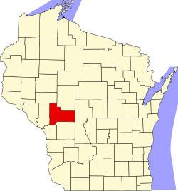
Jackson County, Wisconsin
 Jackson County Courthouse |
|
| administration | |
|---|---|
| US state : | Wisconsin |
| Administrative headquarters : | Black River Falls |
| Address of the administrative headquarters: |
County Courthouse 307 Main Street Black River Falls, WI 54615-1756 |
| Foundation : | 1853 |
| Made up from: | La Crosse County |
| Area code : | 001 715 |
| Demographics | |
| Residents : | 20,449 (2010) |
| Population density : | 8 inhabitants / km 2 |
| geography | |
| Total area : | 2590 km² |
| Water surface : | 33 km² |
| map | |
| Website : www.co.jackson.wi.us | |
The Jackson County is a county in the US -amerikanischen State Wisconsin . In 2010 , the county had 20,449 residents and a population density of 8 people per square kilometer. The county seat is Black River Falls .
geography
The county is located just west of the geographic center of Wisconsin and is approximately 25 miles from Minnesota and Iowa to the west and southwest . It has an area of 2590 square kilometers, of which 33 square kilometers are water.
Jackson County is traversed from north to southwest by the Black River , a left tributary of the Mississippi ,
The following neighboring counties border Jackson County:
| Eau Claire County | Clark County | |
| Trempealeau County |

|
Wood County |
| La Crosse County | Monroe County | Juneau County |
history
Jackson County was formed in 1853 from parts of La Crosse County. It was named after Andrew Jackson , the seventh President of the United States.
population
| Population development | |||
|---|---|---|---|
| Census | Residents | ± in% | |
| 1900 | 17,466 | - | |
| 1910 | 17,075 | -2.2% | |
| 1920 | 17,746 | 3.9% | |
| 1930 | 16,468 | -7.2% | |
| 1940 | 16,599 | 0.8% | |
| 1950 | 16,073 | -3.2% | |
| 1960 | 15,151 | -5.7% | |
| 1970 | 15,325 | 1.1% | |
| 1980 | 16,831 | 9.8% | |
| 1990 | 16,588 | -1.4% | |
| 2000 | 19,100 | 15.1% | |
| 2010 | 20,449 | 7.1% | |
| 2012 estimate | 20,485 | 0.2% | |
| 1900–1990 2000 2010–2012 | |||
According to the 2010 census , Jackson County had 20,449 people in 8,167 households. The population density was 8 people per square kilometer. Statistically, 2.32 people lived in each of the 8167 households.
The racial the population was composed of 89.4 percent white, 2.1 percent African American, 6.6 percent Native American, 0.3 percent Asian, 0.1 percent Polynesian and other ethnic groups; 1.5 percent were descended from two or more races. Regardless of ethnicity, 2.8 percent of the population was Hispanic or Latino of any race.
22.4 percent of the population were under 18 years old, 60.8 percent were between 18 and 64 and 16.8 percent were 65 years or older. 46.8 percent of the population was female.
The median income for a household was 43,098 USD . The per capita income was $ 21,526. 16.5 percent of the population lived below the poverty line.
Jackson County localities
Census-designated places (CDP)
Other Unincorporated Communities
structure
Jackson County is divided into 21 towns in addition to one city and five villages :
|
|
|
See also
Individual evidence
- ↑ Jackson County in the United States Geological Survey's Geographic Names Information System.Retrieved February 22, 2011
- ↑ a b c U.S. Census Bureau, State & County QuickFacts - Jackson County, WI ( Memento of the original from July 12, 2011 on WebCite ) Info: The archive link was automatically inserted and has not yet been checked. Please check the original and archive link according to the instructions and then remove this notice. Retrieved February 18, 2014
- ^ A b National Association of Counties.Retrieved February 18, 2014
- ^ Extract from Census.gov.Retrieved February 28, 2011
- ↑ Missouri Census Data Center - Wisconsin ( Memento of the original from January 18, 2016 in the Internet Archive ) Info: The archive link was inserted automatically and has not yet been checked. Please check the original and archive link according to the instructions and then remove this notice. Retrieved February 18, 2014
Web links
Coordinates: 44 ° 19 ′ N , 90 ° 49 ′ W

