
Kornburg, Worzeldorf
|
Kornburg, Worzeldorf
Statistical District 49 City of Nuremberg
Coordinates: 49 ° 21 ′ 21 ″ N , 11 ° 5 ′ 58 ″ E
|
|
|---|---|
| Height : | 340–355 m above sea level NN |
| Area : | 19.43 km² |
| Residents : | 13,250 (Dec. 31, 2015) |
| Population density : | 682 inhabitants / km² |
| Incorporation : | July 1, 1972 |
| Incorporated into: | Nuremberg |
| Postal code : | 90455 |
| Area code : | 0911 |
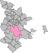
 Location of the statistical district 49 Kornburg, Worzeldorf in Nuremberg
|
|
 Worzeldorf canal harbor
|
|
Kornburg, Worzeldorf is the name of a statistical district in the south of Nuremberg . It belongs to the statistical district 4 “Südliche Außenstadt” .
geography
location
The statistical district 49 includes the Kornburg district and the Worzeldorf district .
Markings
District 49 includes the district 3479 Worzeldorf completely and the districts 3411 Eibach in the northwest, 3412 Eibacher Forst in the east, 3423 Gibitzenhof in the north, 3435 Katzwang in the southwest and 3438 Kornburg in the southeast in parts.

District 3411 Eibach

District 3412 Eibacher Forst
District 3423 Gibitzenhof

District 3435 Katzwang

District 3488 Eibach

District 3479 Worzeldorf


Statistical district
| Neighboring statistical districts | |||||||||
|---|---|---|---|---|---|---|---|---|---|
|
.svg)
Statistical Districts
The district consists of the districts 490 Eibacher Forst (Steinbrüchlein), 491 Eibacher Forst ( Königshof ), 492 Weiherhaus , Herpersdorf , 493 Worzeldorf, 494 Kornburg, 495 Kornburg, Worzeldorf (Ritterholz), 496 Gaulnhofen and 497 Greuth .
literature
- Kornburg, Worzeldorf . In: Michael Diefenbacher , Rudolf Endres (Hrsg.): Stadtlexikon Nürnberg . 2nd, improved edition. W. Tümmels Verlag, Nuremberg 2000, ISBN 3-921590-69-8 ( complete edition online ).
- District data sheet Nuremberg - Statistical District 49 Kornburg, Worzeldorf , as of 2015 (PDF; approx. 120 kB)
Web links
Individual evidence
- ^ City of Nuremberg, Office for Urban Research and Statistics for Nuremberg and Fürth (ed.): Statistical Yearbook of the City of Nuremberg 2016 . December 2015, ISSN 0944-1514 , 18 Statistical City Districts and Districts, p. 244–245 , p. 244 ( nuernberg.de [PDF; 6.3 MB ; accessed on November 1, 2017]).
- ^ City map service Nuremberg District 49 Kornburg, Worzeldorf
.svg)
.svg)
(0) Old town and closer inner city : (01) Old town, St. Lorenz | (02) Marienvorstadt | (03) Tafelhof | (04) Gostenhof | (05) Himpfelshof | (06) Old Town, St. Sebald | (07) St. Johannis | (08) Pirckheimerstraße | (09) Wöhrd • (1) Further inner city belt south : (10) Ludwigsfeld | (11) Glockenhof | (12) Guntherstrasse | (13) Galgenhof | (14) Hummelstein | (15) Gugelstrasse | (16) Steinbühl | (17) Gibitzenhof | (18) Sandreuth | (19) Schweinau • (2) Further inner city belt west / north / east : (20) St. Leonhard | (21) Sündersbühl | (22) Bärenschanze | (23) Sandberg | (24) Bielingplatz | (25) Uhlandstrasse | (26) Maxfeld | (27) Veilhof | (28) Tullnau | (29) Gleißhammer • (3) Southeastern outer city : (30) Dutzendteich | (31) Marshalling yard settlement | (32) Langwasser Northwest | (33) Langwasser Northeast | (34) Beuthener Strasse | (35) Altenfurt North | (36) Langwasser Southeast | (37) Langwasser Southwest | (38) Altenfurt, Moorenbrunn | (39) Nuremberg-Feucht business park • (4) Southern outer city : (40) Hasenbuck | (41) Marshalling yard | (42) Katzwanger Strasse | (43) Dianastraße | (44) Trier Street | (45) Garden City | (46) Werderau | (47) Maiach | (48) Katzwang, Reichelsdorf Ost, Reichelsdorfer Keller | (49) Kornburg, Worzeldorf • (5) South-western outskirts : (50) Hohe Marter | (51) Röthenbach West | (52) Röthenbach Ost | (53) Eibach | (54) Reichelsdorf | (55) Krottenbach, Mühlhof • (6) Western outer city : (60) Großreuth near Schweinau | (61) Gebersdorf | (62) Gaismannshof | (63) Courts | (64) Eberhardshof | (65) Muggenhof • (7) Northwest outer city : (70) Westfriedhof | (71) Schniegling | (72) Wetzendorf | (73) book | (74) clay | (75) Almoshof | (76) Kraftshof | (77) Neunhof | (78) Boxdorf | (79) Großgründlach • (8) Northeastern outer city : (80) Schleifweg | (81) Schoppershof | (82) Sheep Farm | (83) Marienberg | (84) brick | (85) Mooshof | (86) Buchenbühl | (87) Airport • (9) East outer city : (90) St. Jobst | (91) Erlenstegen | (92) Mögeldorf | (93) Schmausenbuckstrasse | (94) Laufamholz | (95) Zerzabelshof | (96) Fischbach | (97) Well