
Krabi (province)
| Krabi | |
|---|---|
| กระบี่ | |

|
|
| statistics | |
| Capital: | Krabi |
| Telephone code: | 075 |
| Surface: |
4,708.5 km² 46. |
| Residents: |
426,556 (2009) 61. |
| Population density : | 91 E / km² 58. |
| ISO 3166-2 : | |
| Governor : | |
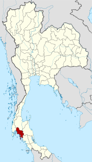
| map | |
  |
|
Krabi ( Thai : จังหวัด กระบี่ , pronunciation: [ t͡ɕaŋwàt kràʔbìː ]) is a province ( Changwat ) in the southern region of Thailand . The capital of the province is also called Krabi .
geography
Krabi is located about 800 kilometers south of Bangkok .
The wooded province is located on the coast of the Indian Ocean , the Andaman Sea . Particularly noteworthy are the numerous limestone cones that protrude as small islands on land and from the sea. Climbers from all over the world come here - especially to the beach of Rai Leh ( Thai : อ่าว ไร่ เล ย์ ) - to climb.
The province of Krabi has 130 islands with a coastline of 120 kilometers, ranging from Ko Hai in the south to Ko Chong Lad in the north. Most of the islands can be reached by ferry from Ao Nang Beach or the ferry terminal in Krabi Town . The following have already been developed:
- Ko Hong Archipelago ( หมู่ เกาะ ห้อง ),
- Ko Poda ( เกาะ ปอ ดะ ),
- Ko Si Boya (also Ko Sri Bo Ya, เกาะ ศรี บอ ยา ),
- Ko Cham (also Ko Jum, เกาะ จั ม ),
- Ko Yung ( เกาะ ยุง ),
- Ko Phi Phi ( หมู่ เกาะ พี พี )
- Ko Lanta Yai and Ko Lanta Noi.
The coast and islands were badly damaged in the December 26, 2004 tsunami .
The distance to the capital Bangkok is about 870 kilometers, to Phuket (from Krabi Town) about 175 kilometers and to Ko Lanta (road) about 80 kilometers.
| Adjacent provinces and areas: | |
|---|---|
| north | Phang-nga and Surat Thani |
| east | Nakhon Si Thammarat |
| south | Trang and coast to the Andaman Sea |
| west | Waterline to Phuket |
climate
The climate is tropical - monsoonal .
Economy and Importance
In addition to tourism as the main source of income, fishing is important, and agriculture is also practiced.
Data
In 2008, the province's gross provincial product was 49,018 million baht .
Wirtschaftszweig      2006  2007  2008
Landwirtschaft        45,5  46,3  49,6
Industrie              9,1  10,0   9,0  Alle Angaben in %
Andere                45,4  43,7  41,4
The minimum wage in the province is 184 baht per day (around € 4).
Land use
The following land use is documented for the province:
- Forest area : 615,401 Rai (384.6 km²), 20.9% of the total area
- Agricultural area : 1,795,487 Rai (1,122.5 km²), 61.0% of the total area
- Unclassified area : 531,487 rai (332.2 km²), 18.1% of the total area
traffic
Airport
- Krabi Airport (KBV)
history
Krabi Province was already inhabited 25,000 to 30,000 years ago by people who lived in caves. The grotto long Rongrien (discovered in 1982), which is located 15 kilometers away from the provincial capital, one of the oldest human settlements in Asia could have been. At the end of the last ice age about 9000 years ago, the sea level rose to the present level. 2000 to 3000 years ago, cave walls were painted with drawings of people or animals in ocher or black colors.
The first written evidence already exists around 1200 BC. From the Kingdom of Ligor when the city of Ban Thai Samor is mentioned as part of the kingdom. From the 5th century there was a sea trading post at Klong Thom, where merchants from all over the world exchanged goods.
In modern history, Krabi was first ruled from Nakhon Si Thammarat, even after Krabi was granted city status in 1872. The province was then established in 1875.
coat of arms
The coat of arms of the Krabi province shows two old crossed swords ( Krabi is the name of an ancient Thai sword), in front of the Indian Ocean and the mountain range Phanom Bencha (Thai: พนม เบญจา ), which is the highest mountain in the province at 1,397 meters.
The local tree is Thung Fa (Thai: ทุ้ง ฟ้า ; Alstonia macrophylla ).
The motto of Krabi Province is:
Krabi is the land of coal ,
fossil shells have been piled up since ancient times,
the city lies between mountain ranges,
beautiful streams and rivers flow calmly,
many islands and palm trees on the sandy beach,
enchanted by the emerald green Andaman Sea and the undersea world,
the paradise of the Phi Phi - Islands amazes everyone.
Attractions

- Ko Phi Phi - archipelago of many smaller islands, of which Phi Phi Don is the largest; Phi Phi Leh is very close and shows the so called Viking Cave and very pretty beaches. Here the film was The Beach rotated. Other islands are Ko Yung ( mosquito island , เกาะ ยุง ) and Ko Mai Phai ( bamboo island , เกาะ ไม้ไผ่ ) with diving opportunities and beautiful beaches.
- Suea Cave ( Thai : ถ้ำ เสือ ) - north-west of Krabi with a meditation center, Wat Tham Suea ("Tiger Cave Temple"); the name comes from a larger stalagmite that is shaped like a tiger.
- " Mussel Cemetery " ( สุสาน หอย , Susan Hoi ) - an accumulation of fossil mussel shells on the sea beach about 20 km from Krabi; at high tide the area is almost completely flooded
- Kanap-Nam-Berg ( เขา ขนาบ น้ำ ) - with a very beautiful stalactite cave
- Diamond Cave ( ถ้ำ เพชร ) - Located at the end of Nam Mao Beach, a large and dark cave with mineral-rich rock that sparkles like a diamond when lit.
National parks
- The Khao Phanom Bencha National Park in the north of the district protects the forests around the Phanom Bencha, the highest point in Krabi Province. There are numerous caves and waterfalls in the densely forested national park. The Maenam Krabi ( Krabi River ) has its source in the hills and flows into Phang Nga Bay near the district capital Krabi. Its estuary with mangrove forests and the Wadden Sea is a wetland protected by the Ramsar Convention .
- The Hat Noppharat Thara - Mu Ko Phi Phi National Park extends over a large area of the coast of Krabi and includes Ao Nang and Hat Nopharat Thara as well as Railay.
- Than Bok Khorani National Park - with many and extensive cave systems
- Ko Lanta Marine National Park - Located on the southern tip of Krabi, with Moken settlements .
Other reserves
- Khao-Nor-Chuchi Game Reserve (also known as Khao Pra-Bang Khram Wildlife Conservation Area ) - one of the last lowland rainforests in Thailand, home to one of the rarest species of birds, Gurney's Pittas .
- Thung Taeo Protection Forest - with a lagoon and a beautiful waterfall
Administrative units
Provincial Administration
Krabi is divided into 8 districts ( Amphoe ), which in turn are divided into 53 parishes ( Tambon ) and 374 villages ( Muban ).
|

Local administration
A provincial administrative organization ( บริหาร ส่วน จังหวัด , อบ จ for short , Ongkan Borihan suan Changwat ; English Provincial Administrative Organization , PAO) exists for the entire area of the province .
In the province there is one city ( เทศบาล เมือง - Thesaban Mueang): Krabi ( เทศบาล เมือง กระบี่ ), in addition there are 9 small towns ( เทศบาล ตำบล - Thesaban Tambon).
Individual evidence
- ↑ Thailand in Figures (2011), p. 389.
- ↑ Thailand in Figures (2011)
- ↑ Thailand in Figures (2011)
- ↑ Department of Provincial Administration : As of 2012 (in Thai)
literature
- Thailand in Figures 2011 . Nonthaburi: Alpha Research 13 A. 2011. ISBN 9786167526034 .
Web links
- Overview map of Krabi Province (names in English and Thai) [last accessed on October 23, 2013]
North : Chiang Mai | Chiang Rai | Kamphaeng Phet | Lampang | Lamphun | Mae Hong Son | Nakhon Sawan | Nan | Phayao | Phetchabun | Phichit | Phitsanulok | Phrae | Sukhothai | Tak | Uthai Thani | Uttaradit
Northeast : Amnat Charoen | Bueng Kan | Buri Ram | Chaiyaphum | Kalasin | Khon Kaen | Loei | Maha Sarakham | Mukdahan | Nakhon Phanom | Nakhon Ratchasima | Nong Bua Lam Phu | Nong Khai | Roi Et | Sakon Nakhon | Si Sa Ket | Surin | Ubon Ratchathani | Udon Thani | Yasothon
Central : Ang Thong | Ayutthaya | Bangkok | Chachoengsao | Chai Nat | Chanthaburi | Chon Buri | Kanchanaburi | Lop Buri | Nakhon Nayok | Nakhon Pathom | Nonthaburi | Pathum Thani | Phetchaburi | Prachin Buri | Prachuap Khiri Khan | Ratchaburi | Rayong | Sa Kaeo | Samut Prakan | Samut Sakhon | Samut Songkhram | Saraburi | Sing Buri | Suphan Buri | Stepped
South : Chumphon | Krabi | Nakhon Si Thammarat | Narathiwat | Pattani | Phang-nga | Phatthalung | Phuket | Ranong | Satun | Songkhla | Surat Thani | Trang | Yala
Coordinates: 8 ° 3 ' N , 98 ° 55' E