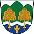
Krhová
| Krhová | ||||
|---|---|---|---|---|
|
||||
| Basic data | ||||
| State : |
|
|||
| Region : | Zlínský kraj | |||
| District : | Vsetín | |||
| Area : | 805 ha | |||
| Geographic location : | 49 ° 29 ' N , 18 ° 0' E | |||
| Height: | 312 m nm | |||
| Residents : | 1,787 (March 1, 2001) | |||
| Postal code : | 756 63 | |||
| License plate : | Z | |||
| traffic | ||||
| Street: |
Valašské Meziříčí - Nový Jičín Valašské Meziříčí - Rožnov pod Radhoštěm |
|||
| Railway connection: | Valašské Meziříčí – Rožnov pod Radhoštěm | |||
| Next international airport : | Ostrava | |||
| structure | ||||
| Status: | local community | |||
| Districts: | 1 | |||
| administration | ||||
| Mayor : | Kateřina Halaštová (as of 2016) | |||
| Address: | Krhová 205 756 63 Valašské Meziříčí |
|||
| Website : | www.krhova.cz | |||
Krhová (German Krhowa , 1939-1945 Kirhow ) is a municipality in the Czech Republic . It is located two kilometers northeast of Valašské Meziříčí and belongs to the Okres Vsetín .
geography
Krhová extends in the southwestern foothills of the Veřovické vrchy in the valley of the brook Krhůvka or Krhovský potok. To the north rises the Obilná (411 m), in the northeast the Budička (508 m), Oprchlice (639 m) and Vlčí vrch (545 m), east of the Černý kopeček (395 m), in the southeast of the Na Hrádcích (344 m) , south of the Štěpánov (409 m), in the west of the Helštýn (383 m) and northwest of the Na Brdech (422 m). The Kojetín – Český Těšín (“Moravian-Silesian Urban Railway ”) line passes by without stopping on the western edge of the town . South of the village runs in the valley of Rožnovská Bečva, the railway line Valašské Meziříčí – Rožnov pod Radhoštěm . The Krhová train station is located there by the Drážky settlement . In the north the road I / 57 leads from Krásno nad Bečvou to Nový Jičín , to the south the European road / state road I / 35 from Krásno nad Bečvou to Rožnov pod Radhoštěm.
Neighboring towns are Obora, Hostašovice and Kulíšek in the north, Jehličná and Pod Žernovým in the north-east, U Ovčírny and Zašová in the east, Hrádky and Hrachovec in the south-east, Drážky and Na Štěpánově in the south, Krásno nad Bečrně, Hrásno nad Bečrně in the south-west Juřinka in the west and Bynina in the northwest.
history
The first written mention of the place took place in 1442 in connection with the Vladiken Hudek von Krhowa. Between 1446 and 1463 Jan Měřička von Těškovice had his seat at the Krhowa Fortress. In 1502 the formerly independent Vladikengut Krhowa was added to the Rožnov domain . Krhowa consisted of twelve farms in 1516. From 1529 Krhowa again formed an independent Vladikengut. This was in turn connected to Rožnov in 1542. In the hoof register of 1667, a steward, eight farms, four gardeners and eleven kötter are shown for Krhowa. 1677 the hereditary bailiff, 14 farmers and eleven kötter are recorded in the land register of the Meziříčí manor. In 1718 the place was called Krchowa . In 1746 bathing began northeast of the village at the iron-sulfur spring Jehličná. In the years 1805-1808, school lessons began in private homes. The inhabitants of the village lived from agriculture.
After the abolition of patrimonial Krhová / Krhowa formed from 1850 a community in the district administration Meziříčí. In 1853 a single-storey schoolhouse was inaugurated. After the founding of the glass factory in Krásno, the majority of the residents earned their living there from 1855. In 1861 the Wittigsbad was inaugurated in Jehličná, and healing therapies with pine needles were offered in the spa. A little later, an inn opened in Jehličná, which has become a popular place for excursions. From 1872 the place was called Krhov / Krhow . After the school had been enlarged by one floor, two-class teaching began in 1878. Since 1885 the municipality name is again Krhová / Krhowa . At the end of the 19th century, two thirds of the population worked for the Reich glass factory. Others found work in the Hrachovec brickworks and the tobacco factory in Nový Jičín . The volunteer fire brigade was founded in 1911. In 1913 a new school building was built, which is still used as a primary school today. In 1938 a small knitwear factory was established in Krhová, which was shut down ten years later as part of the communist reorganization of the industry. There was also a branch of the Lipta wooden toy cooperative in the village . Together with the municipality of Bynina , Krhová negotiated in vain in 1944 and 1945 about the establishment of a joint railway station on the route from Kojetín to Moravian Ostrava . In 1953 Krhová was incorporated into Valašské Meziříčí. After the cancellation of the Okres Valašské Meziříčí, the place was assigned to the Okres Vsetín in 1960. In 1991 there were 1704 people in Krhová. The 2001 census counted 1787 residents and 507 houses. The village has always been parish, depending on the Valašské Meziříčí.
On April 21, 2012, the residents of the place decided to separate from Valašské Meziříčí, so that Krhová becomes an independent municipality again from January 1, 2013.
Community structure
The settlements Drážky, Kulíšek and Jehličná belong to Krhová.
Attractions
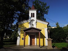
- Chapel, built in 1897
- The Liberation Monument on Helštýn
- Monument to TG Masaryk with the names of those who died in both world wars
- Memorial plaque for the Soviet news group "Karel 20" at the inn
- Iron-sulfur spring in Jehličná
Sons and daughters of the place
- Rudolf Pernický (1915–2005), Czechoslovak Foreign Legionnaire, resistance fighter against the German occupying power and the communists
Web links
Individual evidence
- Jump up ↑ Krhová a Poličná si odhlasovaly odtržení od Valašského Meziříčí (Czech) , Mladá fronta dnes . April 22, 2012. Retrieved April 23, 2012.


