Menucourt
| Menucourt | ||
|---|---|---|

|
|
|
| region | Île-de-France | |
| Department | Val d'Oise | |
| Arrondissement | Pontoise | |
| Canton | Vauréal | |
| Community association | Cergy-Pontoise | |
| Coordinates | 49 ° 2 ′ N , 1 ° 59 ′ E | |
| height | 85-188 m | |
| surface | 3.68 km 2 | |
| Residents | 5,771 (January 1, 2017) | |
| Population density | 1,568 inhabitants / km 2 | |
| Post Code | 95180 | |
| INSEE code | 95388 | |
| Website | http://www.menucourt.fr/ | |
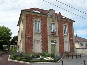
 Menucourt Town Hall |
||
Menucourt is a French municipality with 6681 inhabitants (as of January 1 2017) in the department of Val-d'Oise in the region of Ile-de-France . It is located on the northwestern periphery of Paris . Courdimanche is part of the Pontoise arrondissement and the Vauréal canton . The inhabitants are called Menucourtois (es) .
geography
Menucourt is located about 36 kilometers northwest of Paris in the Vexin .
The neighboring municipalities of Menucourt are Sagy in the north, Courdimanche in the east, Boisemont in the southeast, Vaux-sur-Seine in the south, Évecquemont in the southwest and Condécourt in the west.
Population development
| year | Residents |
|---|---|
| 1962 | 697 |
| 1968 | 726 |
| 1975 | 4082 |
| 1982 | 4666 |
| 1990 | 4592 |
| 1999 | 5084 |
| 2006 | 5182 |
| 2011 | 5363 |
Attractions
- Saint-Léger church, built in 1899 on the site of the earlier Romanesque church with a neo-Byzantine facade
literature
- Le Patrimoine des Communes du Val-d'Oise. Flohic Éditions, Volume 1, Paris 1999, ISBN 2-84234-056-6 , pp. 368-369.
Web links
Commons : Menucourt - collection of images, videos and audio files
Individual evidence
- ↑ INSEE: Population development of Menucourt 1962-2011 ( page no longer available , search in web archives ) Info: The link was automatically marked as defective. Please check the link according to the instructions and then remove this notice.

