
Longuesse
| Longuesse | ||
|---|---|---|
|
||
| region | Île-de-France | |
| Department | Val d'Oise | |
| Arrondissement | Pontoise | |
| Canton | Vauréal | |
| Community association | Vexin Center | |
| Coordinates | 49 ° 4 ′ N , 1 ° 56 ′ E | |
| height | 45-132 m | |
| surface | 8.5 km 2 | |
| Residents | 542 (January 1, 2017) | |
| Population density | 64 inhabitants / km 2 | |
| Post Code | 95450 | |
| INSEE code | 95348 | |
| Website | http://www.mairie-longuesse.fr/ | |
 Town hall (Mairie) of Longuesse |
||

Longuesse is a municipality with 542 inhabitants (as of January 1, 2017) in the Val-d'Oise department in France . The municipality belongs to the Arrondissement of Pontoise and the canton of Vauréal (until 2015: canton of Vigny ). The residents call themselves Longuessois (es) .
geography
Longuesse is located on the Aubette , about 35 kilometers northwest of Paris city center. The municipality is part of the Vexin français Regional Nature Park . Longuesse is surrounded by the neighboring communities of Vigny in the north, Ableiges in the northeast, Sagy in the east, Condécourt in the south, Gaillon-sur-Montcient in the southwest, Seraincourt in the west and southwest and Théméricourt in the northwest.
Population development
| year | 1962 | 1968 | 1975 | 1982 | 1990 | 1999 | 2006 | 2013 |
|---|---|---|---|---|---|---|---|---|
| Residents | 227 | 246 | 304 | 310 | 425 | 511 | 527 | 531 |
| Source: Cassini and INSEE | ||||||||
Attractions
See also: List of Monuments historiques in Longuesse
- Saint-Gildard church, monument historique since 1910
- Manor house on Grande Rue
- Wash houses
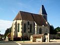
Saint-Gildard Church

Manor house on Grande Rue

Orleans Cross

Wash-house on the Aubette
,_%C3%A9glise_Saint-Gildard,_Grande_Rue.jpg)
,_manoir,_Grande_Rue.jpg)
,_croix_d%27Orl%C3%A9ans_5.JPG)
,_lavoir,_rue_de_l%27Aubette.jpg)
literature
- Le Patrimoine des Communes du Val-d'Oise. Flohic Éditions, Volume 2, Paris 1999, ISBN 2-84234-056-6 , pp. 1003-1004.