
Montgeroult
| Montgeroult | ||
|---|---|---|
.svg)
|
|
|
| region | Île-de-France | |
| Department | Val d'Oise | |
| Arrondissement | Pontoise | |
| Canton | Pontoise | |
| Community association | Vexin Center | |
| Coordinates | 49 ° 5 ' N , 2 ° 0' E | |
| height | 40-101 m | |
| surface | 4.97 km 2 | |
| Residents | 369 (January 1, 2017) | |
| Population density | 74 inhabitants / km 2 | |
| Post Code | 95650 | |
| INSEE code | 95422 | |
| Website | http://www.mairie-montgeroult.fr/ | |
,_mairie,_rue_de_la_Vall%C3%A9e_(RD_92).jpg) Town hall (Mairie) of Montgeroult |
||

Montgeroult is a French village with 369 inhabitants (as of January 1 2017) in the department of Val-d'Oise in the region of Ile-de-France ; it belongs to the Arrondissement of Pontoise and the Canton of Pontoise (until 2015: Canton of Vigny ). The inhabitants are called Montgeroldiens .
geography
Montgeroult is located in the Vexin français landscape , about seven kilometers west-northwest of Pontoise and about 35 kilometers northwest of Paris . Montgeroult is surrounded by the neighboring communities Cormeilles-en-Vexin in the north, Boissy-l'Aillerie in the east, Puiseux-Pontoise in the south and south-east, Courcelles-sur-Viosne in the south and Ableiges in the west. The entire municipality is part of the Vexin français Regional Nature Park .
Population development
| year | 1962 | 1968 | 1975 | 1982 | 1990 | 1999 | 2006 | 2013 |
| Residents | 314 | 332 | 316 | 297 | 347 | 411 | 423 | 395 |
| Source: Cassini and INSEE | ||||||||
Attractions
See also: List of Monuments historiques in Montgeroult
- Notre-Dame-de-l'Assomption church, founded around 1070, monument historique since 1941
- Montgeroult castle with park from the 17th century, monument historique since 1958/1977
- Wash house
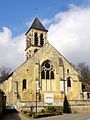
Notre-Dame-de-l'Assomption church

Montgeroult Castle
,_%C3%A9glise_N.D._de_l%27Assomption,_fa%C3%A7ade_du_chevet_2.jpg)
.JPG)
literature
- Le Patrimoine des Communes du Val-d'Oise. Flohic Éditions, Volume 2, Paris 1999, ISBN 2-84234-056-6 , pp. 1004-1005.