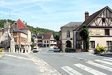
La Roche-Guyon
| La Roche-Guyon | ||
|---|---|---|

|
|
|
| region | Île-de-France | |
| Department | Val d'Oise | |
| Arrondissement | Pontoise | |
| Canton | Vauréal | |
| Community association | Vexin-Val de Seine | |
| Coordinates | 49 ° 5 ' N , 1 ° 38' E | |
| height | 13-143 m | |
| surface | 4.61 km 2 | |
| Residents | 478 (January 1, 2017) | |
| Population density | 104 inhabitants / km 2 | |
| Post Code | 95780 | |
| INSEE code | 95523 | |
| Website | http://www.larocheguyon.fr/ | |
 La Roche-Guyon as seen from the donjon (keep) |
||
La Roche-Guyon is a French municipality with 478 inhabitants (at January 1, 2017) in the department of Val-d'Oise in the region of Ile-de-France ; it belongs to the Arrondissement of Pontoise and the Canton of Vauréal . La Roche-Guyon is classified as one of the Plus beaux villages de France ( Most Beautiful Villages in France ).
geography
La Roche-Guyon is the westernmost municipality in the Val-d'Oise department. It lies on the right bank of a loop of the Seine below the rocks of the Plateau du Vexin . The municipality is known for the La Roche-Guyon castle , which is owned by the La Rochefoucauld family and overlooked by the remains of the old castle. In the 19th century, the place became a recreation area, where many artists stayed. La Roche-Guyon is located in the southwest of the Val-d'Oise department on the borders of the Île-de-France and Normandy . Paris is about 66 km southeast, Pontoise 40 km east. Neighboring municipalities are: Amenucourt in the north, Chérence in the northeast, Haute-Isle in the east, Moisson in the southeast, Freneuse and Gommecourt in the southwest and Gasny in the west. The municipality is part of the Vexin français Regional Nature Park .
history
A small necropolis from the Merovingian period proves that the area was already settled in the early Middle Ages. With the Treaty of Saint-Clair-sur-Epte (911), La Roche, a town on the border with Normandy, gained strategic importance. A first cave castle was built for defense, around 1190 a donjon was added, which was connected to the castle by a staircase cut through the rock. In the 13th century a castle was built below the castle, which gradually made the inhabited caves disappear.
The name of the community comes from the Latin rupes (rock) and the proper name Guy, which means "Guy's rock" - from the 10th to the 15th century, the place was owned by the Guy de la Roche family , which was owned by the Silly family was inherited, who in turn ruled here until 1628. Their successors were the Rohan-Chabot and finally the La Rochefoucauld, who lost their property on site due to the revolution, but still live in the castle today.
During the Second World War, the Wehrmacht set up a command center in the castle. Erwin Rommel partly commanded measures against the invasion of Normandy from here .
In the early 1960s, plans arose to demolish the municipality of La Roche-Guyon and instead build a new capital in the style of Brasília and thus transform La Roche-Guyon into a Monaco on the Seine . The community successfully fought against the plans of the architects Albert Laprade and Jean Brasilier. The speculation did not end until La Roche-Guyon was included in the list of the most beautiful villages in France.
Population development
| year | 1962 | 1968 | 1975 | 1982 | 1990 | 1999 | 2007 |
|---|---|---|---|---|---|---|---|
| Residents | 556 | 631 | 603 | 567 | 561 | 550 | 468 |
Attractions
See also: List of Monuments historiques in La Roche-Guyon
- La Roche-Guyon Castle
- the orchard and vegetable garden belonging to the castle, Potager du château de la Roche-Guyon Jardin remarquable
- La Roche-Guyon Town Hall
- Hotel de la gabelle
Personalities
- The Dukes of La Roche-Guyon from the House of La Rochefoucauld
- Antoinette de Pons , Countess of La Roche-Guyon and Marquise of Guercheville (around 1570–1632)
- Anne Robert Jacques Turgot, baron de l'Aulne (1727–1781)
- Déodat Gratet de Dolomieu (1750–1801)
- Erwin Rommel (1891–1944)
- Joseph Kosma (1905–1969)
literature
- Alain Quenneville, Thierry Delahaye: La Roche-Guyon, l'un des plus beaux villages de France . 1996, ISBN 2-905684-69-0 .
Web links
- Official website of the city (French)
- La Roche-Guyon . Les plus beaux villages de France (French)
Individual evidence
- ^ La Roche-Guyon in Les plus Beaux Villages de France (French).


