Champagne-sur-Oise
| Champagne-sur-Oise | ||
|---|---|---|

|
|
|
| region | Île-de-France | |
| Department | Val d'Oise | |
| Arrondissement | Pontoise | |
| Canton | L'Isle-Adam | |
| Community association | Haut Val-d'Oise | |
| Coordinates | 49 ° 8 ′ N , 2 ° 15 ′ E | |
| height | 23-176 m | |
| surface | 9.45 km 2 | |
| Residents | 5,018 (January 1, 2017) | |
| Population density | 531 inhabitants / km 2 | |
| Post Code | 95660 | |
| INSEE code | 95134 | |
| Website | http://www.champagne95.fr/ | |
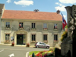
 Champagne-sur-Oise town hall |
||
Champagne-sur-Oise is a French municipality with 5018 inhabitants (as of January 1 2017) in the department of Val-d'Oise in the region of Ile-de-France ; it belongs to the Arrondissement of Pontoise and the canton of L'Isle-Adam . The inhabitants are called the Champenois .
geography
Champagne-sur-Oise is located about 31 kilometers north of Paris on the right bank of the Oise on the border with the Oise department in the Vexin Regional Nature Park . Champagne-sur-Oise is surrounded by the neighboring communities Ronquerolles and Chambly in the north, Persan in the east, Mours in the south-east, L'Isle-Adam in the south, Parmain in the west and Hédouville in the north-west.
The A16 autoroute runs through the municipality .
Population development
| 1962 | 1968 | 1975 | 1982 | 1990 | 1999 | 2006 | 2011 |
| 2.136 | 2,381 | 2,666 | 3.110 | 3,700 | 3,889 | 4,404 | 4,685 |
Attractions
- Church Notre-Dame de l'Assomption , built between the 12th and 13th centuries in the Gothic style, monument historique
- 16th century cemetery cross (Monument historique)
- Hotel-Dieu , former hospice, built around 1270 (Monument historique)
- Wash house
- Estate of the painter Auguste Boulard
- Montigny Castle
- Former presbytery
See also: List of Monuments historiques in Champagne-sur-Oise
literature
- Le Patrimoine des Communes du Val-d'Oise. Flohic Éditions, Volume 1, Paris 1999, ISBN 2-84234-056-6 , pp. 92-97.


