
Upper Harz water shelf
| Upper Harz water management | |
|---|---|
|
UNESCO world heritage |
|

|
|
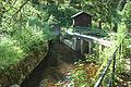
| Ponds of the Upper Harz water shelf near Buntenbock south of Clausthal-Zellerfeld |
|
| National territory: |
|
| Type: | Culture |
| Criteria : | (i) (ii) (iii) (iv) |
| Reference No .: | 623 |
| UNESCO region : | Europe and North America |
| History of enrollment | |
| Enrollment: | 1992 (session 16) |
| Extension: | 2010 |
The Oberharzer Wasserregal or the Oberharzer Wasserwirtschaft is a system mainly created in the 16th to 19th centuries for the diversion and storage of water, which drove water wheels in the mines of the Upper Harz mining industry . It is considered the world's most important pre-industrial water management system of mining .
To the production of hydroelectric power resulting plants are as since 1978 a cultural monument under monument protection . On July 31, 2010 the buildings were declared a UNESCO World Heritage Site by the UNESCO World Heritage Committee under the name Bergwerk Rammelsberg, Old Town of Goslar and Upper Harz Water Management as an extension of the existing World Heritage Site " Rammelsberg Mine and Goslar Old Town " due to their uniqueness and their large size .
Most of the facilities will continue to be operated, with the main purpose of maintaining a historical cultural landscape, nature conservation , tourism and bathing. From a water management point of view, some reservoirs still have a purpose in flood protection and drinking water production . They extend over an area of around 200 square kilometers in the Lower Saxon part of the Harz Mountains , with most of the structures in the Clausthal-Zellerfeld , Hahnenklee , Sankt Andreasberg , Buntenbock , Wildemann , Lautenthal , Schulenberg , Altenau and Torfhaus area.
The water shelf

In this context, shelf means royal sovereignty . With the mountain shelf , the sovereign granted the right to mine and with the water shelf the right to use the available water. Other water users, particularly water mills , had a lower priority . This water shelf was part of the mountain freedom and was valid in Lower Saxony until the 1960s. The frequently used term Upper Harz water management is not precise enough for these historical facilities, as an intensive modern water management system has also arisen in the Upper Harz through dams over the past hundred years .
The Upper Harz Mining
The Upper Harz was once one of the most important metal areas in Germany. The main products of the Upper Harz mining industry were silver , copper , lead and iron , and from the 19th century also zinc . The main source of income was silver. From the 16th to the middle of the 19th century, an average of around 40–50% of the silver mined in all of Germany was extracted in the Upper Harz. The taxes to be paid on it contributed significantly to the tax revenues of the dynasty and royal houses of Hanover and Braunschweig-Wolfenbüttel , because they secured them power and influence within the German Empire . The lucrative mining industry justified a high level of innovation and investment, as well as technical expertise.
Mining and water

Mining is very energy-intensive as soon as it goes significantly deeper. In the Upper Harz, mining was operated as gang ore mining . The mining followed the almost vertical veins in the depth. But already after a few meters of depth, seeping water made it much more difficult to mine. Initially, this was skimmed off with leather buckets by men standing on ladders, the so-called water servants. Through the use of horses and göpel systems , larger amounts of water could be lifted. Horses were expensive and had to be changed regularly after a few hours. Therefore efforts were made to use hydropower , at least in the rich, deep mines . She worked continuously 24 hours a day after her establishment. For this purpose, streams were diverted to water wheels that powered piston pumps in order to raise water from greater depths and in large quantities. The principle was to lift water through water.
An adequate supply of impact water was always necessary for the operation of the water wheels . Although the Upper Harz Mountains have an annual rainfall of over 1,300 millimeters a year, the mines were mostly very high in the area near the watersheds , where there were only few productive streams. In addition, the mountain streams carry very varying amounts of water in the rocky terrain. After a few weeks with little rainfall, the hydropower supply to the mines was often at risk. This meant that some mines had to be abandoned.
In their heyday, the Upper Harz mines were among the deepest in the world. So by 1700 shaft depths of 300 meters were exceeded. Around 1830 a depth of 600 meters was reached and was thus - what was considered significant at the time - below sea level. However, large shaft depths require a correspondingly higher amount of energy to pump ore and mine water. The high energy requirement, combined with the difficult water supply, therefore forced particularly high efforts. Often the miners erected new hydraulic structures in the periods when no extraction was possible due to the lack of impact water. If the water wheels stopped turning, the underground pit water could no longer be pumped; the mine “drowned” and the miner was “driven out”. During these phases, work concentrated on expanding the facilities of the Upper Harz water shelf.
Water supply and storage elements

Overall, the construction of 143 reservoirs, 500 kilometers of ditches and 30 kilometers of underground watercourses for the collection, diversion and storage of surface water can be proven. In addition, water solution tunnels with a length of around 100 kilometers are assigned to the water shelf . However, these were never all in operation at the same time. The Harz waterworks today operate 65 reservoirs, 70 kilometers of ditches and 20 kilometers of watercourses and maintain them. Some smaller reservoirs are still in the care of the Lower Saxony State Forests or are privately owned.
The principle of the aqueduct is to collect the water in trenches that run almost parallel to the contour lines of the slopes and to channel it into the mining region. These ditches can be ten or more kilometers long (like the Dammgraben or the Obere Schalker Graben). In some cases, the water collected in this way was not fed directly to the water wheels, but was stored in reservoirs ( artificial ponds ) in order to have enough impact water available even in dry periods . The water could be discharged from the bottom outlets of the reservoirs into a system of ditches to act on the water wheels. Usually several waterwheels were arranged in a cascading manner one behind the other, so that the water could drive several waterwheels one after the other. In order to be able to direct the water over as many water wheels as possible, it had to be collected, stored and forwarded at the highest possible level.
The technology at the time did not allow dams to be built with a height of more than about 15 meters. This also spoke in favor of creating many small ponds rather than a few large ones. The cascade arrangement of the ponds made it possible to keep the water high , that is, to store it and transfer it to the highest level in order to drive as many water wheels as possible. Several pond cascades, which shape the landscape and consist of four to six ponds, have emerged.
Most of the water wheels were artificial and were used to drive pumps. Sometimes the force had to be transmitted to the mine via several hundred meter long transmissions, so-called field rods . More important mines also had a rotary wheel that was used to extract the ores and debris. All water wheels were overshot . Except for a few reconstructions, the waterwheels have disappeared over the last century.

Vaulted arches at the Zellerfelder Kunstgraben

Hikers on the Morgenbrodstaler Graben near Dammhaus
Regulation device for the flow of water through the dam ditch

Reconstruction of a sweeper wheel with a diameter of 9.5 meters in Clausthal-Zellerfeld

Model of a water art near Clausthal-Zellerfeld.


Buildings
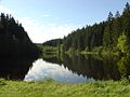
Reservoirs
See: Upper Harz Ponds
The 143 reservoirs and dams were dammed by means of earth dams . Today around 65 dams are still in operation. The dam heights vary between 4.0 and 15.0 meters; the storage volume averages around 150,000 cubic meters.
Trenches
See: Oberharzer Trenches
The trenches are slope trenches parallel to the contour lines with a very low gradient of less than one per thousand and are accompanied by a trench path.
Watercourses
See: Upper Harz Watercourses
The watercourses (water transfer tunnel) between 20 and 1000 meters long were the most expensive investments made by the Upper Harz water shelf. They were nevertheless worthwhile because of their lower operating costs and higher hydraulic performance.
Special structures
- The Sperberhaier Damm is an aqueduct built between 1732 and 1734 with a length of over 900 meters and a height of 16 meters.
- The Oderteich differs considerably from the other Upper Harz ponds in terms of its building materials and dimensions. After its completion in 1722 until the beginning of modern dam construction in 1892, it was the largest dam in Germany.
- In the Polsterberger Hubkunst , water from the dam ditch could be pumped to a level 18 meters higher using hydropower.
- The Huttaler counterbalance is often mentioned in this context , which is relatively complex and allows water to flow in two different directions.
Hut pond near Altenau

The dam of the Klein-Clausthaler pond

Huttaler counterbalance with mouth hole of the Huttaler watercourse

Outlet opening of the Lower Hasenbacher watercourse


history
Emergence
Mining activities in the Upper Harz can be traced back to the 3rd century AD on the basis of archaeological evidence. There must have been a great heyday in the 12th and 13th centuries, when mining in the entire Harz was organized and administered by the monks of the Cistercian monastery of Walkenried . The first use of water wheels to supply energy to the mines, which was documented for the 13th century in the Pandelbachtal south-east of Seesen , also fell during this period .
The medieval plague largely depopulated the Harz and brought mining in Upper Harz to a virtual standstill. A significant revival took place from around 1520 at the instigation of the Brunswick-Wolfenbüttel duke Henry the Younger . His son Duke Julius von Wolfenbüttel in particular pushed the ore mining in Upper Harz that had begun and initiated the construction of a large number of ponds and ditches.
The large-scale use of water power made the upswing of mining in the Upper Harz possible. The ever deeper mines required more and more energy over time. Water shortage after months with little rainfall or after longer periods of frost has repeatedly been a limiting factor for mining. The expansion was carried out by raising existing pond dams, building new dams, building new trenches and extending existing trench tours.
Other improvements: watercourses and water solution tunnels

An example of the further expansion of the water shelf is the optimization of some ditch routes (Dammgraben, Oberer and Unterer Rosenhöfer Falls), which was carried out mainly in the 19th century, by creating so-called watercourses (water transfer tunnels). Through them, the trench tour could be shortened significantly. This enabled safe winter operation as water does not freeze underground. Furthermore, the maintenance costs for a short tunnel section were significantly lower than for a longer trench route. A particular advantage, however, was the higher hydraulic performance: due to the shorter distance with the same height difference, the watercourse had a higher gradient. Initially the underground sections were laboriously with hammer and chisel ascended . Later black powder was also used as an explosive, which made the construction of the waterways much easier and promoted.
Since most of the energy was required for dewatering and the need for this increased more and more with the deepening mines, attempts were made early on to reduce it by building water solution tunnels . For this purpose, stretches were driven from the mine into the valleys through which the water could run off in a free gradient. The lower the drainage level, the longer the tunnels had to be. The longest of these tunnels, the Ernst-August-Tollen , built in the middle of the 19th century , is 35 kilometers long. It collects the water from the mines in Bockswiese , Lautenthal, Zellerfeld, Clausthal and Wildemann and carries it to Gittelde on the edge of the Harz.
Climax and decline

Around 80–90% of the reservoir ponds of the Upper Harz water shelf were created between the 16th and 17th centuries, while the dam ditch system was expanded until the middle of the 19th century. These structures contributed significantly to the fact that the Harz became Germany's largest industrial area in the early modern period . The invention of the steam engine and electrical energy did not immediately change the use of hydropower. These forms of energy were gradually introduced in the Upper Harz. When the steam engine was introduced, until the Innerstetalbahn was built , the difficulties of getting coal in sufficient quantities naturally played a role.
With the nationalization of the mines on January 1, 1864 by the Kingdom of Hanover , not only the mountain freedoms but also all water usage rights fell to the state. The Kingdom of Hanover thus also claimed the water shelf, which was first legally defined in the Prussian Water Act of 1913 § 16 and § 381 . After the Kingdom of Hanover was annexed to the Kingdom of Prussia , the Royal Prussian Mining Inspection and later Preussag took over the operation of the mines in the Upper Harz Mountains.
An inventory from 1868 showed that a total of 198 water wheels with different diameters and a total output of around 3000 HP (approx. 2.2 MW) were driven by the Upper Harz water shelf .
Around 1900 shaft depths of 1000 meters were reached. The mining of ores became more and more complex. At the same time one had to compete with other metal extracts at home and abroad with ever better transport options. Overexploitation during the First World War and very low metal prices in the world economic crisis caused their peak around 1930 a large decommissioning wave, were forced to close as large mines in Clausthal-Zellerfeld, Bockswiese and Lautenthal. In Bad Grund , the Upper Harz ore mining continued until 1992, but only a small part of the systems of the Upper Harz Water Shelf was required for operation.
Power generation

After mining ceased in 1930, the water from the Upper Harz water shelf was used to generate electricity, with some new structures being built. Power generation was carried out by Preussag until 1980 in the Kaiser Wilhelm (maximum output 4.5 MW ) and Ottiliae (maximum output 1.5 MW) shafts . The hydropower plants were shut down at the beginning of the 1980s after the water rights had expired and the profitability of the power plants declined more and more with sharply rising wages and stagnating electricity prices. In Sankt Andreasberg, the water from the Oder pond, which is brought in via the Rehberger Graben , is still used today to generate electricity. In addition to the Teichtal and Grundstrasse power plants, there are two power plants in the Samson mine : the Grüner Hirsch power plant at 130 meters and the Sieberstollen power plant at 190 meters.
The water shelf today
After the power stations were shut down, the water shelf systems were initially transferred to the Lower Saxony state forest administration, which put a lot of work and money into maintenance through the Clausthal-Schulenberg forestry office. In order to relieve the state budget, the Harz waterworks were entrusted with the task of operating and maintaining 65 reservoirs, 70 kilometers of ditches and 20 kilometers of watercourses from 1991 . The Harz waterworks take care of the Upper Harz water shelf from their Clausthal depot. Public funds are not used for this: the costs for maintenance, an annual seven-figure amount, must be paid for by the Harz waterworks themselves through their drinking water sales. With a few exceptions, most ponds can be used for swimming in summer. The majority is leased to local fishing clubs.
In addition to the systems managed by the Harz waterworks, there are also a large number of remains of dams, watercourse mouth holes and, above all, several hundred kilometers of ditches that are not maintained. These structures enjoy a so-called passive monument protection . This means that, similar to a castle ruin, they are exposed to natural, very slow decay, but also may not be destroyed by modern measures without permission under monument protection law.
The Hirschler Pond is used for Clausthal-Zellerfeld and Altenau and the Upper and Middle Kellerhalsteich for Zellerfeld is used by the Clausthal-Zellerfeld municipal utilities for drinking water. Hahnenklee gets its drinking water from the Auerhahnteich , the New Grumbacher and the Upper Kellerhalsteich.
Tourist development
Due to the large number of structures and the length of the trenches, the Upper Harz water shelf is best viewed by hiking. At the instigation of the Harz waterworks, many water hiking trails have been created in recent years . Information boards on marked paths allow you to get to know the typical elements of the Upper Harz water shelf. The touristic development is supplemented by the "World Heritage Foundation in the Harz", which is now in the process of gradually setting up "World Heritage Paths". Guided tours, usually in the form of guided hikes, are also offered from there.
In the Upper Harz Mining Museum, a small computer can also be borrowed with the E.guide EMIL , which leads over a 4-kilometer hiking route and explains the traces of mining and the systems of the Upper Harz water shelf.
The Upper Harz Mining Museum also has a branch on the site of the Harz waterworks at Kaiser-Wilhelm-Schacht. In the former wash house of the mine, a variety of exhibits are presented that document the history and technology of the water shelf.

See also
- Rammelsberg mine, old town of Goslar and Upper Harz water management
- Harz region
- Ore Mountains mining region
Similar systems
There are similar systems for the energy supply of mines with the Revierwasserlaufanstalt in the historical silver mining near Freiberg , in the Norwegian Kongsberg , in Schemnitz (today Slovakia) as well as with the Unterharzer pond and ditch system in the Unterharz. It has been proven that there was a lively exchange of experience between these areas. The Oberharzer Wasserregal, however, is the most extensive and most networked system, both in terms of the number and overall size (trench lengths, storage volumes, etc.) of the structures.
literature
- Martin Schmidt : The water management of the Upper Harz mining industry . In: Series of publications by the Frontinus Society. V . 3rd, supplemented edition. Issue 13. Harzwasserwerke, Hildesheim 2002, ISBN 3-00-009609-4 .
- Mathias Döring: Montane energy generation through hydropower in the Harz and Ore Mountains . Writings of the German Water History Society 3/2003, 21–46. ISBN 3-8330-0729-X .
- Walter Knissel , Gerhard Fleisch: cultural monument "Upper Harz water shelf" . An epoch-making achievement. 2nd Edition. Paper plane, Clausthal-Zellerfeld 2005, ISBN 3-89720-725-7 .
- Reinhard Roseneck : The Upper Harz Water Management in: Archeology in Lower Saxony , 2007, pp. 62–67
- Mathias Döring, Justus Teicke: Upper Harz water management raised to a world cultural heritage . Writings of the German Water History Society 14/2010, 133–149. ISBN 978-3-8391-8665-7 .
- Justus Teicke: UNESCO World Heritage Upper Harz Water Management - The Upper Harz Water Shelf, the most important pre-industrial energy generation and supply system in the world . Harzwasserwerke, Clausthal-Zellerfeld 2011 ( harzwasserwerke.de [PDF; 2.8 MB ]).
- Martin Schmidt: WasserWanderWege, a guide through the Upper Harz water shelf - world cultural heritage . Ed .: Harzwasserwerke GmbH. 4th edition. Papierflieger Verlag, Clausthal-Zellerfeld 2012, ISBN 978-3-86948-200-2 .
- Mathias Döring: World Heritage Upper Harz Water Management . In: University of Siegen, Handbook for Theory and Practice V / 2015, 135-153.
- Series of publications: History of water management . Ed .: Oberharzer Geschichts- und Museumsverein eV 1st edition. Papierflieger Verlag, Clausthal-Zellerfeld 2015, ISBN 978-3-86948-460-0 , p. 195 .
Web links
- UNESCO World Heritage in the Harz Mountains
- UNESCO World Heritage Upper Harz Water Management - Harz Waterworks PDF file
- Entry on the UNESCO World Heritage Center website ( English and French ).
- Upper Harz water management as a representation of the Mining Archeology department of the Lower Saxony State Office for Monument Preservation
- Oberharzer Wasserregal Internet presence of the operator Harzwasserwerke GmbH
- The Upper Harz Water Management Private website of a tourist guide. Retrieved January 10, 2012.
- The elements of the Upper Harz water shelf Private website of a local blogger. Retrieved April 26, 2018.
Individual evidence
- ↑ a b Upper Harz Water Management is a World Cultural Heritage Press release of the German UNESCO Commission from August 1, 2010, accessed on July 17, 2011
- ↑ a b c d Hugo Haase : Engineering structures of old water management in the Upper Harz . 5th edition. Pieper, Clausthal-Zellerfeld 1985, ISBN 3-923605-42-0 .
- ↑ UNESCO World Heritage Upper Harz Water Management - Harz Waterworks PDF file
- ↑ a b c d e f g Martin Schmidt: The water management of the Upper Harz mining industry . 3. Edition. Harzwasserwerke GmbH, Hildesheim 2002, ISBN 3-00-009609-4 (series of publications by the Frontinus Society, issue 13).
- ↑ a b Gerhard Fleisch: The Upper Harz Water Management in the past and present . Clausthal University of Technology, Clausthal-Zellerfeld 1983.
- ^ Wilhelm Bornhardt : Lead, silver and copper production in the Upper Harz and on the Rammelsberg . (Lower Saxony Mountain Archive Clausthal, IV B 1b 151, around 1900).
- ↑ a b c Walter Knissel , Gerhard Fleisch: cultural monument "Oberharzer Wasserregal" - an epochal achievement . 2nd Edition. Paper plane, Clausthal-Zellerfeld 2005, ISBN 3-89720-725-7 .
- ^ A b Wilfried Ließmann: Historical mining in the Harz . 3. Edition. Springer, Berlin 1997, ISBN 978-3-540-31327-4 .
- ^ Friedrich Wilhelm Conrad Eduard Bornhardt: Wilhelm August Julius Albert and the invention of iron wire ropes . VDI-Verlag, Berlin 1934.
- ↑ a b c d Justus Teicke: Dams on the way to becoming a world cultural heritage: The Upper Harz water shelf . In: Proceedings of the 14th German Dam Symposium, reports from the chair and the research institute for hydraulic engineering and water management . Technical University of Munich, Munich September 2007 ( talsperrenkomitee.de [PDF; 1.5 MB ]). talsperrenkomitee.de ( Memento from May 18, 2016 in the Internet Archive )
- ↑ a b c Martin Schmidt: The cultural monument Upper Harz water shelf . Harzwasserwerke, Clausthal-Zellerfeld 2005 ( goslar.de [PDF; 880 kB ]).
- ↑ a b c d Martin Schmidt: WasserWanderWege, a guide through the Upper Harz water shelf - world cultural heritage . Ed .: Harzwasserwerke GmbH. 4th edition. Papierflieger Verlag, Clausthal-Zellerfeld 2012, ISBN 978-3-86948-200-2 , p. 232 .
- ↑ Lothar Klappauf : For Archeology of the resin in: Reports for the Conservation of Lower Saxony, Lower Saxony, Germany. State Office for Monument Preservation, Hanover, issue 4/1992
- ↑ Markus C. Blaich: Mining archaeological investigations in the Pandelbachtal near Münchehof / Seesen - cultural landscape in the western Harz foreland shaped by the Cistercians , in: Reports on the preservation of monuments in Lower Saxony, publication by the Lower Saxony State Office for Monument Preservation, Hanover, issue 2/2005, pages 49-51
- ↑ Alfred Dumreicher: Entire overview of the water management of the north-western Upper Harz . 1st edition. Oberharzer Geschichts- und Museumsverein eV, Clausthal-Zellerfeld 2000, ISBN 3-9806619-2-X (new edition of the original from 1868).
- ↑ Harz Energie - committed to the local energy transition. (No longer available online.) Harz Energie, archived from the original on January 31, 2017 ; accessed on March 5, 2018 .
- ↑ History: Post-mining period from 1910 until today. Samson Mine Museum, accessed March 27, 2009 .
- ↑ Justus Teicke, Katharina Malek, Der Bruch des Oberen Schalker Teichdammes in July 2017 in: Our Harz, history and stories, culture and nature from the entire Harz, Oberharzer Druckerei and Verlag Fischer & Thielbar GmbH, Clausthal-Zellerfeld, issue 6/2020 , Page 103 ff
- ↑ World Heritage Paths of Knowledge on the website www.welterbeimharz.de, accessed on June 13, 2020
- ↑ Guided tours of the World Heritage on the pages www.welterbeimharz.de, accessed on June 13, 2020
- ↑ Internet pages of the Upper Harz Mining Museum
- ^ Exhibition on the technology and history of the Upper Harz water management at Kaiser-Wilhelm-Schacht

Cultural heritage:
Aachen Cathedral (1978) |
Speyer Cathedral (1981) |
Würzburg Residence with Hofgarten and Residenzplatz (1981) |
Pilgrimage Church on the Wies (1983) |
Palaces of Augustusburg and Falkenlust in Brühl (1984) |
Cathedral and Michaeliskirche in Hildesheim (1985) |
Roman monuments, cathedral and Church of Our Lady in Trier (1986) |
Historic Hanseatic City of Lübeck (1987) |
Palaces and Parks of Potsdam and Berlin (1990) |
Lorsch Abbey (1991) |
Rammelsberg mine, old town of Goslar and Upper Harz water management (1992) |
Maulbronn Monastery Complex (1993) | Old Town of Bamberg (1993) |
Collegiate Church , Castle and Old Town of Quedlinburg (1994) |
Völklinger Hütte (1994) |
Cologne Cathedral (1996) |
The Bauhaus and its sites in Weimar, Dessau and Bernau (1996, 2017) |
Luther memorials in Eisleben and Wittenberg (1996) |
Classic Weimar (1998) |
Museum Island Berlin (1999) |
Wartburg (1999) |
Dessau-Wörlitz Garden Realm (2000) |
Reichenau Monastery Island (2000) |
Zeche Zollverein and coking plant Zollverein (2001) |
Upper Middle Rhine Valley (2002) |
Old towns of Stralsund and Wismar (2002) |
Bremen Town Hall and Bremen Roland (2004) |
Fürst-Pückler-Park Bad Muskau (2004) |
Limits of the Roman Empire : Upper Germanic-Raetian Limes (2005) |
Old town of Regensburg with Stadtamhof (2006) |
Settlements of Berlin Modernism (2008) |
Prehistoric pile dwellings around the Alps (2011) |
Fagus factory in Alfeld (2011) |
Margravial Opera House Bayreuth (2012) |
Bergpark Wilhelmshöhe (2013) |
Carolingian Westwork and Civitas Corvey (2014) |
Hamburger Speicherstadt and Kontorhausviertel with Chilehaus (2015) |
The architectural work of Le Corbusier : two houses in the Weißenhofsiedlung (2016) |
Caves and Ice Age Art of the Swabian Alb (2017) |
Archaeological border complex Haithabu and Danewerk (2018) |
Naumburg Cathedral (2018) |
Ore Mountains Mining Region (2019) |
Augsburg water management system (2019)
Natural heritage:
Messel Pit (1995) |
Wadden Sea of the North Sea (2009) |
Old beech forests (2011)
Former World Heritage:
Dresden Elbe Valley Cultural Landscape (2004–2009)