
Paulhac (Haute-Loire)
| Paulhac | ||
|---|---|---|
|
||
| region | Auvergne-Rhône-Alpes | |
| Department | Haute Loire | |
| Arrondissement | Brioude | |
| Canton | Brioude | |
| Community association | Brioude Sud Auvergne | |
| Coordinates | 45 ° 18 ′ N , 3 ° 21 ′ E | |
| height | 436-646 m | |
| surface | 8.4 km 2 | |
| Residents | 636 (January 1, 2017) | |
| Population density | 76 inhabitants / km 2 | |
| Post Code | 43100 | |
| INSEE code | 43147 | |

Paulhac ( Occitan is identical) is a French municipality with 636 inhabitants (at January 1, 2017) is located in the department of Haute-Loire in the region Auvergne Rhône-Alpes (before 2016 Auvergne ). It belongs to the arrondissement of Brioude and the canton of Brioude (until 2015 Brioude-Nord ). The inhabitants are called Paulhacois .
geography
Paulhac is about 55 kilometers northwest of Le Puy-en-Velay on the Vendage river . Paulhac is surrounded by the neighboring municipalities of Beaumont in the north, Brioude in the east, Saint-Laurent-Chabreuges in the south and Saint-Beauzire in the west and southwest.
Population development
| year | 1962 | 1968 | 1975 | 1982 | 1990 | 1999 | 2006 | 2013 |
| Residents | 337 | 375 | 350 | 425 | 561 | 618 | 654 | 664 |
| Source: Cassini and INSEE | ||||||||
Attractions
- Saint-Jean-Baptiste church from the 13th century, a historic monument since 1980
- Paulhac Castle, Monument historique since 2004

Saint-Jean-Baptiste church
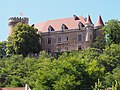
Paulhac Castle


Web links
Commons : Paulhac - collection of images, videos and audio files