
Prades (Haute-Loire)
| Prades | ||
|---|---|---|
|
||
| region | Auvergne-Rhône-Alpes | |
| Department | Haute Loire | |
| Arrondissement | Brioude | |
| Canton | Gorges de l'Allier-Gévaudan | |
| Community association | Rives du Haut Allier | |
| Coordinates | 45 ° 2 ′ N , 3 ° 36 ′ E | |
| height | 535-880 m | |
| surface | 4.82 km 2 | |
| Residents | 64 (January 1, 2017) | |
| Population density | 13 inhabitants / km 2 | |
| Post Code | 43300 | |
| INSEE code | 43155 | |

Prades is a French municipality with 64 inhabitants (at January 1, 2017) in the Haute-Loire in the region Auvergne Rhône-Alpes (before 2016 Auvergne ). It belongs to the Arrondissement of Brioude and the canton of Gorges de l'Allier-Gévaudan (until 2015 Langeac ).
geography
Prades is located about 25 kilometers west-southwest of Le Puy-en-Velay on the Allier River , into which the Seuge flows here. Neighboring municipalities of Prades are Saint-Julien-des-Chazes in the north, Saint-Bérain in the east, Monistrol-d'Allier in the south, Cubelles in the southwest and Charraix in the west.
Population development
| year | 1911 | 1921 | 1931 | 1946 | 1954 | 1962 | 1968 | 1975 | 1982 | 1990 | 1999 | 2006 | 2008 | 2011 | 2013 | 2016 | 2017 |
|---|---|---|---|---|---|---|---|---|---|---|---|---|---|---|---|---|---|
| Residents | 369 | 293 | 250 | 202 | 162 | 131 | 116 | 84 | 113 | 57 | 62 | 60 | 62 | 64 | 69 | 65 | 64 |
| Source: Cassini and INSEE | |||||||||||||||||
Attractions
- Saint-André church from the 12th century, monument historique since 1910
- Servière basalt cliffs
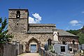
Saint-André church
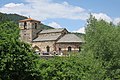
Exterior view of Saint-Andrés
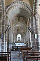
Saint-André with a view of the altar

Servière basalt cliffs


_Dscn0300-h.jpg)
Web links
Commons : Prades - collection of images, videos and audio files