Rückersdorf (Thuringia)
| coat of arms | Germany map | |
|---|---|---|

|
Coordinates: 50 ° 49 ' N , 12 ° 13' E |
|
| Basic data | ||
| State : | Thuringia | |
| County : | Greiz | |
| Management Community : | Wish village / Elster | |
| Height : | 320 m above sea level NHN | |
| Area : | 12.45 km 2 | |
| Residents: | 730 (Dec. 31, 2019) | |
| Population density : | 59 inhabitants per km 2 | |
| Postal code : | 07580 | |
| Area code : | 036602 | |
| License plate : | GRZ, ZR | |
| Community key : | 16 0 76 062 | |
| Community structure: | Core community; 2 districts | |
| Address of the municipal administration: |
Hauptstrasse 43 07580 Rückersdorf |
|
| Mayor : | Axel Jakob | |
| Location of the community of Rückersdorf in the district of Greiz | ||
The Thuringian community of Rückersdorf is located in the east of the district of Greiz and belongs to the administrative community of Wünschendorf / Elster .
geography
Geographical location
Rückersdorf belongs to the Ronneburg arable and mining area . The western sprat rises on the southern edge of the village and flows north through the village to Mennsdorf and Posterstein . In the southwest of the municipality, the regional watershed runs between the Weißen Elster and the Pleiße . The nearest towns are Ronneburg (5 km north), Berga / Elster (9 km south-west), Crimmitschau (12 km east) and Gera (12 km north-west).
Neighboring communities
Neighboring communities are Braunichswalde , Hilbersdorf , Linda b. Weida , Paitzdorf and the town of Ronneburg in the district of Greiz, Heukewalde and Jonaswalde in the district of Altenburger Land and the town of Crimmitschau in the Saxon district of Zwickau . The latter town only indirectly borders the town of Blankenhain with the town of Großpillingsdorf .
Community structure
Sub-municipalities are the places Haselbach and Reust , incorporated on July 1, 1950 , the latter near (east) the two former Reuster waste dumps of the uranium mining of the SDAG Wismut .
history
Rückersdorf was first mentioned in 1181 in the Bosau tithe directory . Until 1918 Haselbach, Reust and part of Rückersdorf belonged to Saxony-Altenburg and had belonged to the Ronneburg district office since 1900 . The other part of Rückersdorf belonged to the Amtshauptmannschaft Zwickau (exclave Ziegenhierdsches Ländchen ) of the Kingdom of Saxony . As part of the land consolidation of 1928 , the Saxon part of Rückersdorf came to Thuringia and, like the other places belonging to today's municipality, belonged to the Gera district, which had existed since 1922 .
Religions
35% of the population are Protestant, 4% Catholic. The Evangelical Lutheran parishes in Haselbach, Reust and Rückersdorf belong to the Evangelical Church in Central Germany ; the rectory in Ronneburg , Altenburger Land parish , is responsible for them. The few Catholics belong to the parish of St. Elisabeth with seat in Gera , Diocese of Dresden-Meißen ; the next branch church is Maria Birth (Ronneburg) .
Incorporations
On July 1, 1950, Haselbach and Reust were incorporated.
Population development

In 1910 there were 218 inhabitants in the Altenburg part of Rückersdorf and 80 inhabitants in the Saxon part. All together there were 819 inhabitants. In 1939 there were a total of 758 inhabitants.
Development of the population ( December 31 ):
|
|
|
|
|
| Data source: Thuringian State Office for Statistics | ||||
politics
Municipal council
Since the local elections on May 25, 2014 , the local council has been composed as follows:
- CDU / Community of Christian Citizens: 3 seats (+ 2)
- Voting community Reust: 2 (- 1)
- Haselbach volunteer fire department: 2 seats (± 0)
- Rückersdorf volunteer fire brigade: 1 seat (- 1)
The turnout was 71.0% and thus 0.3% p below that of 2009.
Culture and sights
Buildings
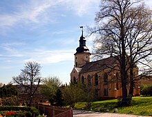
There are three Evangelical Lutheran churches in the community, one in each district. The Rückersdorfer church has a classical nave with a Gothic choir, the tower is mostly baroque . The church in Reuster is partially Gothic and has a late Gothic winged altar that was made around 1500. The church in Haselbach dates from the Baroque and has a side aisle in addition to the main nave with a tower.
On the western edge of Reust, on the 370 m high Reuster Berg, there is the colloquially known Reuster Tower , the Bismarck Column , which offers a wide view of the surroundings, which were previously shaped by the Wismut. The 21 m high square tower is made of limestone from Orlamünde . The choice of location was justified by the fact that the Reuster Berg was the highest elevation in what was then the eastern district of Saxony-Altenburg.
Green spaces and recreation
In the open ground west of the built-up area of Rückersdorf, a biotope was created on an explosives store built in 1956 for the Wismut , which was handed over to the public as an accompanying object of the Expo 2000 . The display boards present 21 types of biotope, which as of 1999 contain 256 types of vascular plants , 69 types of mushrooms , 43 types of birds , 98 types of spiders , 133 types of butterflies and 47 types of wild bees .
Economy and Infrastructure
traffic
The municipal area is crossed by the state road L 1081 from Ronneburg to Werdau , which leads through Reust and touches Rückersdorf via a bypass that was created in the Wismut times. At Rückersdorf the L 1082 branches off, which leads to Linda and Pohlen . The two bus lines 212 Gera – Friedmannsdorf and 213 Gera – Werdau – Zwickau, operated by Regionalverkehr Gera (RVG) and the private bus company Piehler , operate on weekdays , only the former also going to the Haselbach district. Since the end of passenger train traffic on the Wünschendorf – Werdau connection , the nearest passenger station is in Ronneburg, five kilometers away.
media
The Deutsche Funkturm has been operating the 163 meter high Ronneburg transmission tower near Rückersdorf since 1994 .
education
The primary school of the administrative community is housed in Rückersdorf .
Web links
Individual evidence
- ^ Population of the municipalities from the Thuringian State Office for Statistics ( help on this ).
- ^ Municipal directory Germany 1900 - Duchy of Saxony-Altenburg - District Office Ronneburg. Retrieved September 19, 2012 .
- ↑ 2011 census
- ↑ 2014 local elections
- ↑ Local election 2009
- ↑ The Bismarck Column on the Reuster Berg. City of Ronneburg, accessed on July 22, 2017 .
- ↑ Rückersdorf near Gera - Tourism. Rückersdorf community, archived from the original on December 23, 2008 ; Retrieved July 22, 2017 .


