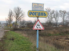
Rohan (Ukraine)
| Rohan | ||
| Рогань | ||

|
|
|
| Basic data | ||
|---|---|---|
| Oblast : | Kharkiv Oblast | |
| Rajon : | Kharkiv Raion | |
| Height : | 127 m | |
| Area : | 3.26 km² | |
| Residents : | 3,449 (2018) | |
| Population density : | 1,058 inhabitants per km² | |
| Postcodes : | 62481 | |
| Area code : | +380 57 | |
| Geographic location : | 49 ° 54 ' N , 36 ° 29' E | |
| KOATUU : | 6325158500 | |
| Administrative structure : | 1 urban-type settlement , 1 settlement | |
| Address: | вул. 1. Травня 1 62481 смт. Роган |
|
| Statistical information | ||
|
|
||
Rohan ( Ukrainian Рогань ; Russian Рогань Rogan ) is an urban-type settlement in the Ukrainian Oblast of Kharkiv with around 3400 inhabitants (2018).
The village, founded in 1650, received the status of an urban-type settlement in 1938 and is the administrative center of the settlement council of the same name within Kharkiv Raion .
Rohan is located on the banks of Rohanka ( Роганка ), a 31-km long left tributary of Udy , and on the highway M 03 / E 40 7 km east of Kharkiv .
The settlement council community Rohan with an area of 61.8 square kilometers still belongs founded in 1944 settlement Dokutschajewske .
Web links
Commons : Rohan - collection of images, videos and audio files
Individual evidence
- ↑ Demographics of Ukrainian cities on pop-stat.mashke.org, accessed on February 14, 2019


