
Schmitten (Hochtaunus)
| coat of arms | Germany map | |
|---|---|---|
.png)
|
Coordinates: 50 ° 16 ' N , 8 ° 27' E |
|
| Basic data | ||
| State : | Hesse | |
| Administrative region : | Darmstadt | |
| County : | Hochtaunuskreis | |
| Height : | 433 m above sea level NHN | |
| Area : | 35.5 km 2 | |
| Residents: | 9487 (Dec. 31, 2019) | |
| Population density : | 267 inhabitants per km 2 | |
| Postal code : | 61389 | |
| Primaries : | 06082, 06084 | |
| License plate : | HG, USI | |
| Community key : | 06 4 34 009 | |
| Community structure: | 9 districts | |
| Address of the municipal administration: |
Parkstrasse 2 61389 Schmitten |
|
| Website : | ||
| Mayor : | Marcus Kinkel (non-party) | |
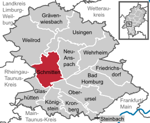
| Location of the community of Schmitten in the Hochtaunus district | ||
  |
||

Schmitten is a municipality and a climatic health resort in the Hochtaunuskreis in southern Hesse .
geography
location
Schmitten is located in the eastern Hintertaunus at the foot of the Großer Feldberg ( 879 m ), the highest Taunus summit , the summit region of which belongs to the municipality, and is the municipality with the highest districts in the Taunus. The Weil , which rises on the northern slope of the Feldberg massif and flows into the Lahn near Weilburg, flows through Schmitten .
Neighboring communities
Schmitten borders in the north on the community of Weilrod and the city of Usingen , in the east on the cities of Neu-Anspach and Bad Homburg , in the south on the cities of Oberursel and Königstein and in the west on the communities Glashütten and Waldems (the latter in the Rheingau-Taunus district ).
structure
The community consists of the nine districts, which were independent communities until the territorial reform of 1972.
| District | coat of arms | Area in km² |
Residents |
|---|---|---|---|
| Arnoldshain |
|
8.26 | 1.917 |
| Brombach |
|
2.98 | 507 |
| Dorfweil |
|
3.67 | 684 |
| Hunoldstal |
|
2.22 | 434 |
| Niederreifenberg |
|
4.15 | 1,354 |
| Oberreifenberg |
|
3.83 | 1,922 |
| Schmitten (old community) |
|
4.05 | 1,320 |
| Seelenberg |
|
3.41 | 570 |
| Treisberg |
|
2.87 | 183 |

history
Schmitten is first mentioned in a document as "Waldschmidt" in 1399, the name refers to a nail smithy located in the forest, which is assigned to Hattstein Castle (mentioned in 1215). The Hattsteiner Knights ("Hazechenstein") were related to the Reifenbergers ("Riffinberg"), probably even identical. The origins of this family come either from the Westerwald north of the Lahn or from the area around Limburg . In the "Walsdorf founding document" from 1156 a "Guntramus de Hazechenstein" is named.
The Hattsteiner knights, whose castle was destroyed several times, owned properties in Bad Camberg , Usingen (" Hattsteinweiher "), Stockheim , Weilbach , Aschaffenburg , Mainaschaff , Königstein and in Frankfurt am Main . The Hattsteiners are also involved in the founding of the Munzenberg Castle in Wetterau .
The von Reiffenberg and von Hattstein families were one of the most influential families in Hesse through the Middle Ages. Philipp von Reifenberg was Imperial War Council, Electoral Mainz Councilor and bailiff , † 1548, Marquard Freiherr von Hattstein was (1560–1581) Bishop of Speyer , Johann Heinrich Freiherr von Reifenberg was Imperial Councilor and Chamberlain , † March 4, 1628 (1613 in the Freiherrenstand moved), and Philipp Ludwig Freiherr von Reiffenberg was canon of Mainz and Trier and first governor of Erfurt , † March 23, 1686.
Together with the Kronberg knights , the Hattsteiners and Reiffenbergers declare the so-called " Kronberg feud " to the city of Frankfurt in 1389 . When the Frankfurters moved to Kronberg Castle with a large contingent on May 14th, troops from Hanau and Palatinate rushed to the aid of the besieged, drove the Frankfurters out at the " Battle of Eschborn " and took numerous prisoners, including the mayor and all the bakers and shoemakers the city. Only the payment of the ransom of 73,000 gold guilders ended the dispute with Frankfurt and established the construction of the " Frankfurter Landwehr " and the four control rooms.
The family of the Hattstein knights, which was inextricably linked with the history of Schmittens, ended with the death of Johann Constantin Philipp von Hattstein (1767).
Territorial reform
Today's Schmitten community emerged as part of the regional reform in Hesse . On April 1, 1972, the municipalities Schmitten, joined Brombach , Hunoldstal and soul Mountain Schmitten in a first step voluntarily to the new community together . The ensuing community was on Aug. 1, 1972 by virtue of national law with the communities Arnoldshain , Dorfweil , Reifenberg and Treisberg to today's Schmitten together . The municipality of Reifenberg was created on December 31, 1971 through the voluntary amalgamation of the municipalities of Niederreifenberg and Oberreifenberg , which at that time belonged to the Main-Taunus district , in order to avoid merging with Schmitten, but existed only for a few months. Against the will of the Reifenberger, the Hessian state parliament passed the reorganization law on July 11, 1972 with the votes of the SPD and FDP in which the large community of Schmitten was formed on August 1, 1972. The state government had proposed "Weilspringe" as the name of the large community. After this proposal did not meet with approval in either the upper or lower districts, Schmitten was chosen as the name. Local districts were not formed in Schmitten.
Jewish community

From around 1800 there was a small Jewish community in Schmitten. On November 15, 1844, the synagogue of this community was inaugurated, which offered space for 57 men and 24 women. The Jewish community itself consisted of 27 in 1843, 20 in 1890 and only 14 in 1932. On July 12, 1890, the district administrator of the Usingen district ordered the merging of the Schmitten Jewish community with that from Anspach. The Jewish community in Schmitten, which consisted of 6 families, resisted this order. The head of culture, Sina Hess, obtained the revocation of this decision by the regional council with a letter of July 30, 1880 and the preservation of the independence of the Schmitten community.
- Synagogue coordinate: 50 ° 16 ′ 8.2 ″ N , 8 ° 26 ′ 39.6 ″ E
In the 1920s, the Jewish community merged with that from Usingen. During the time of National Socialism , the Jewish community was destroyed. In 1937 only a four-member Jewish family lived in Schmitten. On November 9, 1938, the synagogue in Schmitten was desecrated by the Nazis. In 1945 the National Socialists murdered all of Schmittens' Jews. The synagogue was purchased by the community for 200 Reichsmarks and sold to a private person for 600 Reichsmarks. On July 8, 1995, the former synagogue was demolished because it was in disrepair. After the Second World War , the JRSO asserted claims for compensation in relation to the destroyed synagogue and in 1961 received compensation of 27,000 DM from the Darmstadt Regional Council.
Jewish Cemetery
- Coordinate Jewish cemetery: 50 ° 16 ′ 6.1 ″ N , 8 ° 25 ′ 46.1 ″ E
About two kilometers outside of Schmitten, above the waterworks on the slope of the Judenkopf , is the Jewish cemetery. The cemetery was laid out in 1820. The last burial took place around 1935. There are still nine tombstones with Hebrew and German inscriptions in the cemetery. The tenth gravestone from 1812 comes from Arnoldshain's Jewish cemetery. This stone was discovered around 1974 and then transferred to the Schmitten cemetery. The cemetery is maintained by the civil parish.

Stumbling blocks

The only three stumbling blocks in the community of Schmitten were moved around October 13, 2009.
- Coordinate stumbling blocks: 50 ° 16 ′ 8.9 ″ N , 8 ° 26 ′ 30.8 ″ E
Memorial sites to Jewish life in Schmitten
Since July 15, 1995, a memorial stone in Wiegerstrasse (former Synagogenstrasse) on the site of the former synagogue and three stumbling blocks in front of the former hotel of the Strauss family and the remains of the Jewish cemetery near the White Stone have been commemorating Jewish life in Schmitten .
religion
Evangelical
- Evangelical parish of Arnoldshain, responsible for the districts of Arnoldshain, Schmitten, Seelenberg, Oberreifenberg and Niederreifenberg

- Evangelical parish Weilnau (in Weilrod ), responsible for the Treisberg district
- Evangelical church community Rod am Berg (in Neu-Anspach ), responsible for the districts of Hunoldstal, Brombach and Dorfweil
Catholic
The four former Catholic parishes have been part of the new type of parish St. Franziskus and Klara - Usinger Land since January 1st, 2014 . The seat of the parish is Neu-Anspach . Church places are in Schmitten
- St. Karl Borromeo, Schmitten
- St. Casimir, Seelenberg
- St. John the Baptist, Niederreifenberg
- St. Georg, Oberreifenberg
Methodist
Methodist Church Brombach
politics
Community representation
The local elections on March 6, 2016 produced the following result:
| Parties and constituencies |
% 2016 |
Seats 2016 |
% 2011 |
Seats 2011 |
|
| FWG | Free community of voters | 29.0 | 9 | 30.0 | 9 |
| CDU | Christian Democratic Union of Germany | 22.6 | 7th | 25.6 | 8th |
| b-now | Citizens' list New open voter community | 16.7 | 5 | - | - |
| UBB | Independent civic bloc | 10.5 | 3 | 12.4 | 4th |
| Green | Alliance 90 / The Greens | 10.3 | 3 | 16.3 | 5 |
| FDP | Free Democratic Party | 5.7 | 2 | 7.5 | 2 |
| SPD | Social Democratic Party of Germany | 5.2 | 2 | 8.1 | 3 |
| total | 100.0 | 31 | 100.0 | 31 | |
| Turnout in percent | 54.6 | 52.5 | |||
Even today, the contrast between the different parts of the city still shapes municipal politics. There are traditionally two free voter communities in the larger community: The FWG, which provides the mayor, has its core in Arnoldshain , the UBB its focus in both Ober- and Niederreifenberg. In the 2016 local elections, a third community of voters was added with b-now. This became clear again in the 2014 mayoral election. While Mayor Kinkel (FWG) was able to achieve results of around 70 percent in the lower districts, challenger Karl-Heinz-Bös, who was supported by the CDU, UBB and the Greens, succeeded just as clearly in the upper districts.
mayor
Mayors of the municipality since formation were:
- 1972: Hans Kinkel (FWG) (State Commissioner Mayor)
- 1973–1991: Georg Hahl (CDU)
- 1991–1997: Josef Braun (FWG)
- 1997–2003: Markus Töpfer (CDU)
- 2003-today: Marcus Kinkel (until August 2018 FWG, now independent)
The biggest political scandal in the community was the arrest of Mayor Georg Hahl on suspicion of corruption on the day of penance and prayer in 1991.
Community budget
From 2003 to 2013, the municipal budget was no longer balanced. As a result, the amount of debt rose so sharply that the municipality was entitled to be partially exempted under the “ municipal protective umbrella”. The municipal council rejected this offer against votes from the CDU and the Greens in 2012. Nevertheless, property tax B was raised to the extent necessary to ensure that households have been balanced since 2014.
Partnerships
Schmitten has had partnerships with the French municipalities of Courtomer , Moulins-la-Marche and Sainte-Gauburge-Sainte-Colombe since 1981 .
flag
In 1987 the Hessian Ministry of the Interior approved the flag of the municipality, which is described as follows: "The flag of the municipality of Schmitten shows the municipality's coat of arms in the upper half of the flag strip, which is divided lengthways into red, white and blue".
Culture and sights
societies
The largest sports club in the Arnoldshain district is Spvgg Hattstein, which offers a wide range of sports activities.
Climatic health resort

The history of tourism began in the 19th century in what is now Schmitten. The work of the Taunus Club opened up the mountains through hiking trails and shelters and the Feldberg festivals made the Feldberg area known as a travel destination. The first inn on the Feldberg was opened in 1860.
In 1883 the doctor Dr. Wieger (after which the Wiegerstraße in Schmitten and the Wiegerfelsen above the village is named) the Kurverein in Schmitten. He had made it his mission to set up a postal connection to Oberursel (for this purpose the Postverein was founded in 1884), to beautify the townscape in order to make it more attractive for visitors and to set reasonable accommodation prices.
The Kurverein's measures were successful. From 125 guests in 1884, the number of visitors rose to 600 in 1908 and from 3,000 to 4,000 in the 1920s. Prominent visitors such as Kaiser Wilhelm II (on April 5, 1910) or the tsarist family (on September 10, 1910) also visited the Feldberg.
The Kurverein dissolved in 1928. The spa administration was transferred to the community. Today the tourism and culture association supports the community in this task.
Schmitten is still a state-recognized health resort today. In order to maintain this rating, climate reports are drawn up at regular intervals and the tourist infrastructure is verified. However, the importance of tourism has declined significantly today. Today Schmitten is more the destination of day tourists than vacationers. The number of hotels and guest houses has decreased accordingly.
Green spaces and recreation
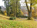
park
The park is located in the center of town between the town hall and the supermarket. The site has been used as a (originally Catholic) cemetery since 1762. In 1848 the cemetery was expanded and also used for Protestant deceased. The last funeral took place in 1897. After the site was cleared in 1940, it was used as a park.
park

Fountain


Medicinal climate park
In the area of the community of Schmitten there are two entry portals to the Hochtaunus climatic park .
Great Feldberg

The highest mountain in the Taunus, the Große Feldberg , attracts hundreds of thousands of visitors every year, especially from the Rhine-Main area. In Oberreifenberg there are lifts for skiing and tobogganing fun. The main attraction is of course the nature of the Taunus and many kilometers of well-tended hiking trails.
Treisberg
The observation tower on the 663 meter high horse head near Treisberg allows a wide view over the Taunus landscape and is the destination of many excursions. In winter, the most attractive ski lifts in the Taunus attract skiers and tobogganists.
Weiltal
Rising on the Feldberg, the Weil meanders through the Taunus Nature Park all the way to Weilburg . The Weiltalweg runs along the Weil . A visit to the Weiltal is popular for families and nature lovers, but also for motorcyclists and cyclists. The Hochtaunusstraße also opens up the Weiltal for automobile tourists.
In addition to the annual Weiltal Marathon, the traditional bicycle race around the Henninger Tower also leads through the upper Weiltal.
Buildings
Cultural monuments
The listed buildings of the community are listed in the list of cultural monuments in Schmitten .
limes
The old border of the Roman Empire, the Limes , runs above Nieder- and Oberreifenberg over the Taunus ridge. The Roman forts Kleiner Feldberg , Altes Jagdhaus and Heidenstock are located in the area of the community of Schmitten . The preserved foundation walls give an insight into the Roman fortress construction.
Reifenberg castle ruins
The keep (substructure, about 33 meters) and residential tower ( Donjon ) of the castle have been preserved and tower over Oberreifenberg and the Weiltal.
Church of St. Charles Borromeo
The church of St. Karl Borromäus is a sight catcher in the core community of Schmitten . Located at the intersection of the town's two thoroughfares, the building cannot be overlooked. In 1893 the church was built in a neo-Gothic style. The building material was the Taunus slate, which was extracted from the rock directly at the construction site. The church therefore looks like it has been fitted into the rock. The neighboring rectory (the church has been a parish church since 1921) is also built from the same material.
The single-nave interior is vaulted by an ogival wooden barrel ceiling. The retracted choir with a ribbed vault ends on three sides.
The equipment from the time of construction was replaced by modern equipment during the restoration in 1967, 1984 and 1989. The eye catcher is a winged altar by the Mainz painter Thomas Vogel (1984) in neo-cubist style, depicting the carrying of the cross, the resurrection and revelation to the unbeliever Thomas.
A Marian grotto in the rock at the church entrance was originally intended as a war bunker; the end of the war in 1945 preceded this use. The figure of Mary by Anneliese Degen comes from the 1950s, as does a Pietà on the staircase.
Next to the church a staircase leads to the Wiegerfelsen, a lookout point above the village.
- Church of St. Charles Borromeo

Schmitten Church, photographed from the front from L 3025 (Schillerstraße)

Schmitten Church, photographed from the Wiegerfelsen

Schmitten Church, photographed from Dorfweiler Strasse


War memorial
On the left in front of the church is the Schmitten community's war memorial . After the First World War , the memorial was financed by donations, created by the Frankfurt sculptor WO Prack and inaugurated on October 25, 1925. In the same style as the church made of local stone, the monument is founded by a fountain with a lion's head. Above it rises the actual memorial from a plaque with the neutral inscription "The community of Schmitten - your fallen sons". On it is a representation of a soldier who tries in vain to help an injured comrade. To the side is a plaque with the names of the Schmitten citizens who died in the World War. After the Second World War, a second plaque was added with those who died at the time.
- War memorial

War memorial

Detail view


Half-timbered houses
The center of Schmitten has a few half-timbered houses:
- Corner house at the Feldberg / Schillerstrasse
- Kanonenstrasse 6-8 (1896; "Kurhaus Ochs")
- Wenzelstraße 1 (around 1750; remnants of a larger farm complex with nail smithy, Schmitten's forester's house in the 19th century)
- To Feldberg 6 ("Schwalbenhof")
Economy and Infrastructure
traffic
The Weiltal has always been a traffic route from the Rhine-Main plain to Weilburg. The pass road Red Cross from Königstein and the one over the Sandplacken meet in Schmitten and lead through the Weiltal to the Lahn. On working days, the VHT bus lines 50/51 via Oberursel- Hohemark to Bad Homburg and the lines 60 and 80 to Königstein and Neu-Anspach provide hourly connections to the rail network. On summer weekends the Weiltalbus offers a cross connection from Bad Homburg to the Lahn valley to Weilburg several times a day.
Established businesses
The largest commercial enterprise in the core community is the company for foundry accessories, the company Karl Schmitt. The loudspeaker manufacturer Heco had its headquarters with production in Schmitten until it was broken up.
education
The community of Schmitten has three primary schools :
- The Jürgen Schumann School in the Arnoldshain district
- The Reifenberg elementary school in the Niederreifenberg district
- The Montessori EcoSchool in the Oberreifenberg district
Furthermore, there is the Dorfweil family holiday facility (also a conference center) in the Dorfweil district and the Evangelical Academy in the " Martin-Niemöller -Haus" in the Arnoldshain district . The Martin-Niemöller-Haus was opened in 1954. The main building was designed by Theo Pabst . It had two halls, several meeting rooms and 68 rooms. In 2011 it was decided to renovate the building for 6.5 million euros.
Leisure and sports facilities

- In the Schmitten district, the highest outdoor pool in Hesse offers refreshment in summer.
- In the Oberreifenberg district, the Taunatours company offers a climbing course, among other things.
Personalities
Sons and daughters of the church
- The oil drilling pioneer Anton Raky and 1841 the theologian Anton Abt were born in Seelenberg in 1868 .
- Wilhelm Windisch (* December 8, 1860; † 1944), since 1885 employee of the fermentation industry and professor at the Agricultural University in Berlin.
Worked in Schmitten
- Gottlieb Schnapper-Arndt (1846–1904) wrote his dissertation in 1883, Five Village Communities on the High Taunus - a social statistical study of small-scale farming, domestic industry and popular life in the 5 communities of the former office of Reifenberg , which today belong to the large community of Schmitten.
- The author and journalist Susanne Fröhlich (* 1962) lives in the Oberreifenberg district .
- The German singer Ivan Rebroff (1931–2008) lived on the outskirts of Hunoldstal .
- The writers Rudolf Harms (1901–1984) and Gerhard Zwerenz (1925–2015) as well as the pastor Paul Kaetzke (1901–1968) lived and died in Schmitten.
literature
- Beatrice Träger: Schmitten becomes a climatic health resort . In: Ingrid Berg: Heimat Hochtaunus . Kramer, Frankfurt 1988, ISBN 3-7829-0375-7 , pp. 466-469.
- Gottlieb Schnapper-Arndt: Five village communities on the Hohe Taunus. A social statistical study of small-scale farming, domestic industry and popular life - Leipzig 1883. (PDF document 38 MB)
- Literature on Schmitten in the Hessian Bibliography
- Literature on Schmitten in the catalog of the German National Library
Web links
- Internet presence of the community of Schmitten
- Schmitten, Hochtaunuskreis. Historical local dictionary for Hessen. In: Landesgeschichtliches Informationssystem Hessen (LAGIS).
- Link catalog on the subject of Schmitten (Hochtaunus) at curlie.org (formerly DMOZ )
Individual evidence
- ↑ Hessian State Statistical Office: Population status on December 31, 2019 (districts and urban districts as well as municipalities, population figures based on the 2011 census) ( help ).
- ↑ a b Usinger - Anzeiger online Retrieved on 14 Aug 2018
- ↑ 77th meeting of the specialist committee for health resorts, recreation places and healing wells in Hesse on November 17, 2011 . In: State pointer for the state of Hesse . No. 7 , 2012, ISSN 0724-7885 , p. 221 .
- ^ Schmitten - the Feldberg community: districts. In: www.schmitten.de. Retrieved October 7, 2016 .
- ↑ Law on the reorganization of the Obertaunus district and the district of Usingen (GVBl. II 330-18) of July 11, 1972 . In: The Hessian Minister of the Interior (ed.): Law and Ordinance Gazette for the State of Hesse . 1972 No. 17 , p. 227 , § 4 ( online at the information system of the Hessian state parliament [PDF; 1,2 MB ]).
- ^ Federal Statistical Office (ed.): Historical municipality directory for the Federal Republic of Germany. Name, border and key number changes in municipalities, counties and administrative districts from May 27, 1970 to December 31, 1982 . W. Kohlhammer GmbH, Stuttgart and Mainz 1983, ISBN 3-17-003263-1 , p. 379 .
- ↑ Gerstenmeier, K.-H. (1977): Hessen. Municipalities and counties after the regional reform. A documentation. Melsungen, p. 272.
- ↑ Gerrit Stolte: Together and yet separated; in: Taunus-Zeitung of April 13, 2012, p. 17
- ↑ Jewish cemetery. In: alemannia-judaica.de .
- ↑ Stumbling blocks frightened residents FRI, October 13, 2009
- ^ Erhard Bus : The Synagogue in Schmitten. In: Yearbook of the Hochtaunuskreis 1997. ISBN 3-7973-0643-1 , pp. 215-221.
- ^ Result of the municipal election on March 6, 2016. Hessian State Statistical Office, accessed in April 2016 .
- ^ Matthias Pieren in: Taunus-Zeitung of August 1, 2007, page 16, "After a protest, nine towns become one community"
- ↑ Schmitten 2014 election results ( Memento of the original from October 28, 2014 in the Internet Archive ) Info: The archive link was inserted automatically and has not yet been checked. Please check the original and archive link according to the instructions and then remove this notice. (PDF)
- ↑ Reiner Scholz: Under the public hand. In: Die Zeit , August 30, 1996.
- ↑ Schmitten without protection and umbrella; in: FAZ of September 25, 2012, p. 43
- ↑ Approval of a coat of arms of the community Schmitten, Hochtaunuskreis from September 14, 1987 . In: The Hessian Minister of the Interior (ed.): State Gazette for the State of Hesse. 1987 No. 40 , p. 2000 , point 845 ( online at the information system of the Hessian state parliament [PDF; 5,7 MB ]).
- ↑ Beatrice Träger: Schmitten becomes a climatic health resort . In: Ingrid Berg: Heimat Hochtaunus . Frankfurt 1988, ISBN 3-7829-0375-7 , pp. 466-469.
- ↑ Chronicle Berlin 1860

Arnoldshain | Brombach | Dorfweil | Hunoldstal | Niederreifenberg | Oberreifenberg | Schmitten | Seelenberg | Treisberg