
Rainau
| coat of arms | Germany map | |
|---|---|---|

|
Coordinates: 48 ° 55 ' N , 10 ° 9' E |
|
| Basic data | ||
| State : | Baden-Württemberg | |
| Administrative region : | Stuttgart | |
| County : | Ostalbkreis | |
| Height : | 478 m above sea level NHN | |
| Area : | 25.44 km 2 | |
| Residents: | 3318 (Dec 31, 2018) | |
| Population density : | 130 inhabitants per km 2 | |
| Postal code : | 73492 | |
| Area code : | 07961 | |
| License plate : | AA, GD | |
| Community key : | 08 1 36 089 | |
| Address of the municipal administration: |
Schlossberg 12 73492 Rainau |
|
| Website : | ||
| Mayor : | Christoph Konle | |
| Location of the community Rainau in the Ostalb district | ||
  |
||

Rainau is a municipality in Baden-Württemberg and belongs to the Ostalb district .
geography
Geographical location
Rainau is located in eastern Baden-Württemberg between Aalen and Ellwangen. It is also in the upper Jagsttal at an altitude of 440 to 502 meters. It is part of the natural areas of the Eastern Alb foreland and the Swabian-Franconian Forest Mountains .
geology
The two natural areas belong to the Swabian Keuper-Lias-Land .
Neighboring communities
The community borders in the north and east on the city of Ellwangen (Jagst) , in the south on Westhausen and the district town of Aalen and in the west on Hüttlingen and Neuler .
Community structure
The community of Rainau with the formerly independent communities of Dalkingen and Schwabsberg includes five villages, hamlets and houses. The village of Dalkingen and the hamlet Weiler belong to the former municipality of Dalkingen . The villages Schwabsberg and Buch and the hamlet of Saverwang belong to the former municipality of Schwabsberg . The hamlets of Schwenningen (now Neuler) and the Jägerhaus as well as the abandoned villages of Kepshaldun and Stokken near Buch were also formerly part of it .
Division of space

According to data from the State Statistical Office , as of 2014.
history
Community merger
In the course of the administrative reform in Baden-Württemberg, the municipality of Rainau was formed on January 1, 1975 from the previously independent municipalities of Schwabsberg and Dalkingen.
Buch, Dalkingen and Schwabsberg
While Dalkingen was mentioned for the first time in 1136, Schwabsberg followed in 1147. The places belonged to the prince provost of Ellwangen since the 15th century , with which they fell to the Kingdom of Württemberg as part of the secularization due to the Reichsdeputationshauptschluss 1803 . However, parts of Dalkingen had belonged to Dinkelsbühl since the 14th century and were initially part of the Kingdom of Bavaria at the beginning of the 19th century . They then also fell to Württemberg in 1810. Both communities of origin in Rainau belonged to the district of Aalen in Württemberg , which became part of the new Ostalb district as a result of the district reform in 1973 . The town of Buch is on the Roman side, which is delimited from the Limes . The Römerbad is located there near the Buch reservoir. It is best known for its tourism and its beauty as a recreation area.
Outsourcing
On January 1, 1977, the area of the hamlet of Schwenningen, which had almost 200 inhabitants at that time, was ceded to the neighboring community of Neuler.
Religions

Due to the affiliation to the Prince Provost of Ellwangen, the Reformation passed Rainau by, so that the community is still shaped by Roman Catholicism today. The few evangelical believers belong to the parish of Ellwangen .
politics
Administrative community
The community is a member of the agreed administrative community of the city of Ellwangen (Jagst) .
mayor
In the second ballot for the mayoral election in Rainau in February 2013, banking economist Christoph Konle was elected the new mayor with 56.5 percent of the vote. He took office on April 2, 2013.
Partnerships
The partner municipality is the municipality of Großolbersdorf in Saxony .


badges and flags
|
|
Blazon : "In red in front an upright golden (yellow) lion, behind a pole-like silver (white) stag pole with ends turned to the left."
The award of the coat of arms and the flag took place on September 9, 1975 by the Ministry of the Interior. |
| Founding of the coat of arms: The community of Rainau, formed on January 1, 1975 by the union of Dalkingen and Schwabsberg, took over the shield image of the Lords of Schwabsberg , who also held Dalkingen as an Ellwangian fiefdom on the 14th and 15th centuries. In contrast to the coat of arms of the nobility, the community has the lion and the stag pole on a red instead of a blue shield. Thus, the current municipal coat of arms contains two figures from the former Schwabsberger and two colors from the former Dalkingen coat of arms. |
Flag : White-Red (Silver-Red)
Attractions
Limes Museum

Limestor near Dalkingen, which was built in five expansion phases

Limestor near Dalkingen
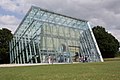
Limestor Dalkingen in its enclosure built in 2010

.jpg)

- The Rhaetian Limes , a UNESCO World Heritage Site since 2005 , crosses the municipality over a length of six kilometers. In the forest, the course of the Limes can still be seen as a rubble wall.
- In the Limes open-air museum you can see:
- The Dalkinger Limestor was declared a cultural monument by the Stuttgart regional council in 2006 . It was found in 1885 by General Eduard von Kallee on the basis of strategic military considerations, exposed for the first time and initially interpreted as a field guard . During further excavations in 1973/1974 it was identified as a building with an area of approx. 12 × 13 m and a triumphal arch-like gate passage. These are the only remains of a gate system on the Upper German-Raetian Limes that have been discovered so far.
- The south gate and an adjacent intermediate tower of the Limes Fort Buch as well as have been restored and conserved
- the fort bath and two adjacent buildings of the camp village ( vicus ) .
Buch reservoir
Immediately next to it is the Buch reservoir , a flood retention basin and a recreation area.
Memorials
Since 1993 a memorial stone on the outskirts of the district of Dalkingen in the direction of Westhausen has been commemorating the Hessental death march of concentration camp prisoners from the Hessental subcamp , who were driven past the site, 20 of whom died and seven others were murdered by SS men. They were then buried in a sand pit. In 1956 the dead were reburied in the Kochendorf concentration camp cemetery .
Sports
The Schwabsberg district is home to the KC Schwabsberg , whose first team is represented in the Kegel Bundesliga (Classic) .
In the district of Buch you will find the local rifle club, which starts with the air rifle in the 1st Bundesliga / South.
Economy and Infrastructure

education
In addition to the primary school in Schwabsberg, there is also a primary school in Dalkingen. There are also three kindergartens in town.
traffic
Rainau is located on the Upper Jagstbahn , the railway line between Aalen and Crailsheim . The regional express train Ulm –Aalen – Ellwangen (–Crailsheim) of the DB Regio stops hourly at the Schwabsberg stop .
The federal highway 290 ( Tauberbischofsheim –Westhausen) and the federal highway 7 , whose junction Aalen / Westhausen is a few kilometers south of Rainau , also run through Rainau .
Local public transport rail and bus lines can be used at the tariffs of the OstalbMobil transport cooperative as well as at the tariffs of the respective transport company.
Long-distance cycle routes
The German Limes Cycle Path leads through the districts of Buch and Dalkingen . It follows the Upper German-Raetian Limes over 818 km from Bad Hönningen on the Rhine to Regensburg on the Danube .
Long-distance hiking trails
The Limes hiking trail of the Swabian Alb Association , a section of the German Limes hiking trail , crosses the Jagst near Rainau .
Personalities
Sons and daughters of the church
- Xaver Rathgeb (1822–1907), born in Weiler, Dalkingen municipality, mayor and member of the state parliament
- Josef Hauber (* 1944), church musician and composer, was born in the Buch district
Web links
Individual evidence
- ↑ State Statistical Office Baden-Württemberg - Population by nationality and gender on December 31, 2018 (CSV file) ( help on this ).
- ↑ a b Natural areas of Baden-Württemberg . State Institute for the Environment, Measurements and Nature Conservation Baden-Württemberg, Stuttgart 2009.
- ^ The state of Baden-Württemberg. Official description by district and municipality. Volume IV: Administrative region of Stuttgart, regional associations of Franconia and East Württemberg. Kohlhammer, Stuttgart 1980, ISBN 3-17-005708-1 , pp. 713-714.
- ↑ State Statistical Office, area since 1988 according to actual use for Rainau.
- ^ Federal Statistical Office (ed.): Historical municipality directory for the Federal Republic of Germany. Name, border and key number changes in municipalities, counties and administrative districts from May 27, 1970 to December 31, 1982 . W. Kohlhammer, Stuttgart / Mainz 1983, ISBN 3-17-003263-1 , p. 471 .
- ^ Federal Statistical Office (ed.): Historical municipality directory for the Federal Republic of Germany. Name, border and key number changes in municipalities, counties and administrative districts from May 27, 1970 to December 31, 1982 . W. Kohlhammer, Stuttgart / Mainz 1983, ISBN 3-17-003263-1 , p. 472 .
- ↑ Coat of arms on LEO-BW
- ↑ Rainau , limesprojekt.de, accessed January 30, 2009.
- ↑ Memorial sites for the victims of National Socialism. A documentation , Volume I. Bonn 1995, ISBN 3-89331-208-0 , pp. 69f.

Basking | Abtsgmünd | Adelmannsfelden | Bartholomä | Böbingen an der Rems | Bopfingen | Durlangen | Ellenberg | Ellwangen (Jagst) | Eschach | Essingen | Göggingen | Gschwend | Heubach | Hypocrites | Hüttlingen | Iggingen | Jagstzell | Kirchheim am Ries | Lauchheim | Leinzell | Lorch | Mögglingen | Mutlangen | Neresheim | Newbie | Obergröningen | Oberkochen | Rainau | Riesbürg | Rosenberg | Ruppertshofen | Schechingen | Schwäbisch Gmünd | Spraitbach | Stödtlen | Panel red | Tannhausen | Unterschneidheim | Waldstetten | Westhausen | Words