Taylor County, Wisconsin
![Taylor County Courthouse, listed on the NRHP since 1980 [1]](https://upload.wikimedia.org/wikipedia/commons/thumb/8/87/Taylor_County_Courthouse_Medford_Wisconsin.jpg/298px-Taylor_County_Courthouse_Medford_Wisconsin.jpg) Taylor County Courthouse, listed on the NRHP since 1980 |
|
| administration | |
|---|---|
| US state : | Wisconsin |
| Administrative headquarters : | Medford |
| Address of the administrative headquarters: |
County Courthouse 224 South 2nd Street Medford, WI 54451-1811 |
| Foundation : | 1875 |
| Made up from: |
Clark County Lincoln County Marathon County Chippewa County |
| Area code : | 001 715 |
| Demographics | |
| Residents : | 20,689 (2010) |
| Population density : | 8.2 inhabitants / km 2 |
| geography | |
| Total area : | 2550 km² |
| Water surface : | 25 km² |
| map | |
| Website : www.co.taylor.wi.us | |
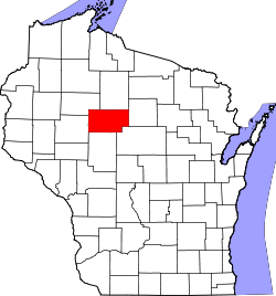
The Taylor County is a county in the US -amerikanischen State Wisconsin . In 2010 , the county had 20,689 residents and a population density of 8.2 people per square kilometer. By 2013 the population had decreased slightly to 20,610. The county seat is Medford .
geography
The county is located in northwestern Wisconsin and has an area of 2550 square kilometers, of which 25 square kilometers are water.
The Black River , a left tributary of the Mississippi, has its source in Taylor County . In addition, the watershed between the catchment areas of the Mississippi tributaries Chippewa River ( Jump River , Yellow River ) and Wisconsin River ( Big Rib River ) runs through Taylor County .
The following neighboring counties border Taylor County:
| Rusk County | Price County | |
| Chippewa County |

|
Lincoln County |
| Clark County | Marathon County |
history
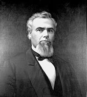
Taylor County was formed in 1875 from parts of Clark County, Lincoln County, Marathon County and Chippewa County. It was named after William R. Taylor (1820-1909), an American politician and governor of Wisconsin.
population
| Population development | |||
|---|---|---|---|
| Census | Residents | ± in% | |
| 1900 | 11,262 | - | |
| 1910 | 13,641 | 21.1% | |
| 1920 | 18,045 | 32.3% | |
| 1930 | 17,685 | -2% | |
| 1940 | 20,105 | 13.7% | |
| 1950 | 18,456 | -8.2% | |
| 1960 | 17,843 | -3.3% | |
| 1970 | 16,958 | -5% | |
| 1980 | 18,817 | 11% | |
| 1990 | 18,901 | 0.4% | |
| 2000 | 19,680 | 4.1% | |
| 2010 | 20,689 | 5.1% | |
| 2013 estimate | 20,610 | -0.4% | |
| 1900–1990 2000 2010–2013 | |||
According to the 2010 census , Taylor County had 20,689 people in 8,810 households. The population density was 8.2 inhabitants per square kilometer. Statistically, 2.32 people lived in each of the 8,810 households.
The racial the population was composed of 98.1 percent white, 0.4 percent African American, 0.3 percent Native American, 0.4 percent Asian, 0.1 percent Polynesian and other ethnic groups; 0.8 percent were descended from two or more races. Hispanic or Latino of any race was 1.7 percent of the population.
23.8 percent of the population were under 18 years old, 58.5 percent were between 18 and 64 and 17.7 percent were 65 years or older. 49.1 percent of the population were female.
The median income for a household was 44,578 USD . The per capita income was $ 22,733. 13.6 percent of the population lived below the poverty line.
Taylor County localities
Census-designated places (CDP)
Other Unincorporated Communities
1 - partially in Marathon County
structure
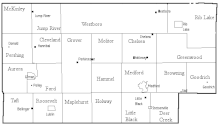
Taylor County is divided into 22 towns in addition to the five incorporated municipalities :
|
|
See also
Individual evidence
- ↑ Extract from the National Register of Historic Places - No. 80000198 Retrieved April 13, 2011
- ^ Taylor County in the United States Geological Survey's Geographic Names Information System.Retrieved February 22, 2011
- ↑ a b c U.S. Census Bureau, State & County QuickFacts - Taylor County, WI. Retrieved August 29, 2014
- ↑ a b National Association of Counties.Retrieved August 29, 2014
- ^ Extract from Census.gov.Retrieved February 28, 2011
- ↑ Missouri Census Data Center - Wisconsin ( Memento of the original from January 18, 2016 in the Internet Archive ) Info: The archive link was inserted automatically and has not yet been checked. Please check the original and archive link according to the instructions and then remove this notice. Retrieved August 29, 2014
Web links
Coordinates: 45 ° 13 ′ N , 90 ° 30 ′ W


