Unterperfuss
|
Unterperfuss
|
||
|---|---|---|
| coat of arms | Austria map | |
|
|
||
| Basic data | ||
| Country: | Austria | |
| State : | Tyrol | |
| Political District : | Innsbruck country | |
| License plate : | IL | |
| Surface: | 2.24 km² | |
| Coordinates : | 47 ° 16 ' N , 11 ° 16' E | |
| Height : | 596 m above sea level A. | |
| Residents : | 222 (January 1, 2020) | |
| Population density : | 99 inhabitants per km² | |
| Postal code : | 6178 | |
| Area code : | 05232 | |
| Community code : | 7 03 61 | |
| NUTS region | AT332 | |
| Address of the municipal administration: |
Hno. 13 6178 Unterperfuss |
|
| politics | ||
| Mayor : | Georg Hörtnagl | |
|
Municipal Council : (2016) (11 members) |
||
| Location of Unterperfuss in the Innsbruck-Land district | ||

|
||
| Source: Municipal data from Statistics Austria | ||
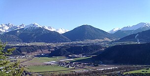
Unterperfuss is a municipality with 222 inhabitants (as of January 1, 2020) in the Innsbruck-Land district in Tyrol ( Austria ). The community is located in the judicial district of Telfs .
geography
Unterperfuss is located in the Inn Valley , about 15 km west of Innsbruck, across from Zirl. In terms of area and population, it is one of the smallest municipalities in Tyrol. The municipal boundaries are formed in the north by the Inn and in the east by the Melach, which flows here from the Sellraintal .
Neighboring communities
- Grin ,
- Kematen in Tyrol ,
- Oberperfuss ,
- Ranggen and
- Zirl
history
The first documentary mention took place in 1312 in the Inntaler tax book as "Niederpervens". The name "Unterperfuss" appears for the first time in 1453 in a document, kept in the Tyrolean State Archives . In 1832 Unterperfuss became an independent local community.
Population development

politics
The last mayoral elections took place at the same time as the municipal council elections on February 28, 2016.
Martin Norz was elected mayor and Georg Hörtnagl was elected deputy mayor. A runoff election was necessary.
| Political party | percent | be right | Seats on the local council | Coupling |
|---|---|---|---|---|
| ÖVP list Unterperfuss - mayor list | 48.32% | 72 | 5 | |
| ÖVP - village list | 27.52% | 41 | 3 | A. |
| SPÖ - General List Unterperfuss | 24.16% | 36 | 3 | A. |
coat of arms
Blazon : The coat of arms is divided into silver and blue by a curve cut. The eight-spoke red wheel is in silver on the left.
Culture and sights
Baroque branch church of St. Catherine, built in 1761 by Franz Singer , design attributed to Johann Michael Umhauser. Quality frescoes by Anton Kirchebner . Rococo decor.
freetime and sports
The municipality has numerous facilities for equestrian sports.
Web links
- 70361 - Unterperfuss. Community data, Statistics Austria .
- Unterperfuss on the website of www.tirol-info.at
Individual evidence
- ↑ Peter Anreiter, Christian Chapman, Gerhard Rampl: The community names of Tyrol. Origin and meaning. Universitätsverlag Wagner, Innsbruck 2009. ISBN 978-3-7030-0449-0
- ↑ https://wahlen.tirol.gv.at/gemeinderats_und_buergermeisterwahlen_2016/gemeinden/unterperfuss.html
- ^ Gertraud Pfaundler-Spat: Tirol-Lexikon. Studienverlag, Innsbruck-Vienna-Bozen 2005. ISBN 3-7065-4210-2


