
Weilbach (Bavaria)
| coat of arms | Germany map | |
|---|---|---|

|
Coordinates: 49 ° 40 ' N , 9 ° 13' E |
|
| Basic data | ||
| State : | Bavaria | |
| Administrative region : | Lower Franconia | |
| County : | Miltenberg | |
| Height : | 152 m above sea level NHN | |
| Area : | 27.28 km 2 | |
| Residents: | 2208 (Dec. 31, 2019) | |
| Population density : | 81 inhabitants per km 2 | |
| Postcodes : | 63937, 63916 | |
| Area code : | 09373 | |
| License plate : | MIL, OBB | |
| Community key : | 09 6 76 165 | |
| Market structure: | 7 districts | |
Market administration address : |
Main street 59 63937 Weilbach, Germany |
|
| Website : | ||
| Mayor : | Robin Haseler ( SPD ) | |
| Location of the Weilbach market in the Miltenberg district | ||
  |
||


Weilbach is a market in the Lower Franconian district of Miltenberg and is located in the Bavarian part of the Odenwald .
geography
Highest and lowest point
The topographically highest point of the municipality is at 478 m above sea level. NN (location) at the summit of the Sansenhöhe at the Sansenhof, the lowest is on the Mud at 133 m above sea level. NN (location) .
Community structure
Weilbach has seven districts in three districts (the type of settlement in brackets):
-
Ohrbach ( hamlet )
- Wiesenthal ( wasteland )
- Weckbach ( Kirchdorf )
-
Weilbach (main town)
- Reuenthal (village)
Surname
etymology
It takes its name from the eponymous Weilbach Weilbach , which the mud flows in the municipality.
Earlier spellings
Earlier spellings of the place from various historical maps and documents:
|
|
history
Until the church is planted
Weilbach was first mentioned in a document in 1201. The knight Cunrat von Wilenbach was a witness in a property belonging to the Dürn house, to which he served. The Lords of Dürn were Staufer ministerials and from 1171 to 1272 patrons of the Amorbach monastery .
For most of its history, Weilbach was under Kurmainz rule. In 1803 Weilbach was added to the Principality of Leiningen and shortly afterwards came with it to the Grand Duchy of Baden . A few years later (1810) Weilbach became part of the Grand Duchy of Hesse-Darmstadt , and since 1816 it has belonged to Bavaria . In the course of the administrative reforms in Bavaria, today's municipality was created with the municipal edict of 1818 .
Administrative history
In 1862 the Miltenberg district office was formed, with Weilbach located on its administrative territory. As everywhere in the German Reich , the term district was introduced in 1939. Weilbach was now one of the 31 communities in the old district of Miltenberg . On July 1, 1972, this merged with the district of Obernburg am Main to form the new district of Miltenberg .

Incorporations
On July 1, 1972, the Reuenthal district of the Reichartshausen community was reclassified to the Weilbach community. During the community reform, which came into force on July 1, 1977, Weckbach was merged with its districts Gönz (incorporated in 1879), Ohrnbach (name until 1870 Ohrnbach-Wiesenthal , incorporated in 1892), Wiesenthal and Sansenhof with Weilbach.
politics
mayor
Robin Haseler (SPD) has been mayor since May 1, 2020; he was elected in the runoff election on March 29, 2020 with 56.8 percent of the vote. The turnout was 77.50%.
His predecessor was Bernhard Kern (Independent List) from May 1996 to April 2020; In his last election on March 16, 2014, he received 79.05% of an opposing candidate. The turnout was 74.30%.
Municipal council
The community council of the market Weilbach consists of 14 voting members. The turnout for the municipal council election in 2020 was 69.74%.
There are no other active local groups of parties in Weilbach. The SPD runs a working group of the young socialists .
Culture and sights, buildings
The church, the historic town center with the three-tube fountain. From the Gotthard ruins, half of which is on the Amorbach district, you have a panoramic view of the Odenwald and into the Spessart.
Gotthard ruins


The church ruin, almost 30 meters long, is a three-aisled pillar basilica without a transept. The choir is rectangular. Adjacent to the south is the former sacristy and to the north is an approximately 17-meter-high stair tower , which is now accessible as a lookout tower . The history of the listed Gotthard ruin (also called Gotthard ruin) at 304 m above sea level. NHN high Gotthardsberg is very eventful and is initially a bit in the dark.
The hilltop, which rises about 150 meters east of the Mud between Weilbach and Amorbach, was formerly known as Frankenberg. According to tradition, the Franconian Count Ruthard built a castle ( Castrum Frankenberg ) here in the 8th century and called the missionaries St. Pirmin and St. Amor, who founded the Benedictine monastery Amorbach around 734, to the Frankenberg (the year has been handed down for this 714). The castle was in 1138 one of the Hl. Godehard of Hildesheim consecrated chapel added. Since then the mountain has been called "Gotthardsberg" or simply "Gotthard".
At the Reichstag in Würzburg in 1168 under Staufer Emperor Friedrich I, known as Barbarossa , the decision was made to destroy the castle because robber barons lived on it. After the destruction, a Cistercian nunnery was built on the Gotthard , from which the two rows of arcades and the ornate warrior friezes still come from what is now the ruins. In 1439 the monastery was dissolved. His tenure was Abbey Amorbach as provost slammed shut. The monastery with all other buildings was burned down in 1525 during the Peasants' War . In 1628, the Amorbach Benedictine abbot Erhard Landecker began its reconstruction as a church, which Archbishop Jodocus consecrated in 1631. Repeatedly damaged in the following years, it burned down on June 8, 1714 due to a lightning strike and has been in ruins since then. To protect it from decay, it was given a roof in 1956.
After the division of the properties of the Amorbach monastery at the end of the 18th century, the boundary of the neighboring communities Weilbach and Amorbach runs lengthways through the middle of the ruins. Especially from the tower you have a wonderful view of seven valleys and the surrounding mountains.

Forest nature trail
An educational forest trail extends around the Gotthard ruins and invites you to explore the forest in a playful way.
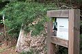
Forest nature trail leaf tunnel
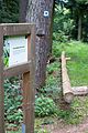
Squirrel phone


Three-tube fountain
The three-tube fountain is located in the center of Weilbach, right at a crossroads. It has a large sandstone trough with a baroque relief. The water gushes out of three pipes. The fountain is also represented in the municipal coat of arms as one of the symbols of the market. For the annual Mardi Gras opening of the “Weilbacher Frösch” carnival society on November 11th, the water is colored green.
Mud mill
At the north-western exit of Weilbach stands the mill with a Renaissance gable, which was converted in 1585 by the Mainz court architect Ambrosius Brosamer.
Hall stones
This is a collection of interesting primeval stones on the Hallhöhe in the west of Weilbach. A signposted hiking trail leads to this natural monument.
Carillon / glockenspiel
There is a bell tower with a carillon in the old schoolyard in Weilbach . The forerunner of the current carillon was a computer-controlled carillon, which was attached to the town hall wall with 24 bells in December 1991. The facility was financed by a private initiative by Weilbach citizens and associations under the umbrella of the home association Weilbach-Weckbach eV
After two years of construction, the current 13.5 m high bell tower was inaugurated on Sunday, June 25, 2006. Extended to 37 bells, it was now also possible to operate the carillon by hand with a built-in stoke piano (2 manuals, 1 pedal). As a result, the Weilbacher Carillon is now one of seven Carillons in Bavaria.
In 2016 the carillon was expanded again and now houses 39 bells with a range of over 3½ octaves from e5 to c2. The bells have a total weight of approx. 2,032 kg, with the smallest bell weighing 14 kg and the largest bell weighing 250 kg. All bells were cast at the Bachert bell foundry .
The carillon sounds computer-controlled daily at 9:10 a.m., 12:10 p.m. and 6:10 p.m.
Architectural monuments
Economy and Infrastructure
Industry
The Eisenhammer factory , which historically belonged to Linde AG , was founded at the beginning of the 19th century . Until 2006, Linde also manufactured floor conveyors and warehouse technology equipment in the “Linde Material Handling” (LMH) division; Among other things, the Linde forklifts became known. The group also owned the well-known brands Still and OM Pimespo. On August 1, 2006, LMH was initially spun off from Linde AG into the newly founded Kion Group GmbH. At the beginning of November 2006 this was sold to a consortium of the finance companies Kohlberg Kravis Roberts & Co. (KKR) and Goldman Sachs to counter-finance the acquisition of BOC for € 4 billion .
As a result of the operation of the iron hammer , several model making companies that produce cast models settled. A pallet factory processes the wood from the Odenwald. A logistics company and companies from the trades are located in the new industrial area south.
The Odenwälder Marzipankonditorei GmbH has existed there since 1977 , a nationally known company that produces marzipan figures and objects of all kinds and sells them nationwide.
traffic
Weilbach is connected to the trunk road network by federal highway 469 . The federal road leads past the community as a bypass. The closest motorway connections to the A3 are Stockstadt (42 km) and Wertheim / Lengfurt (43 km). The district road MIL6 leads into the Odenwald to Vielbrunn .
Weilbach is a stop on the Madonnenlandbahn Seckach – Miltenberg. In Seckach the line branches off from the Neckarelz – Osterburken line and in Miltenberg from the Maintalbahn . In Seckach there is a connection to the Rhein-Neckar S-Bahn , which is integrated into the Rhein-Neckar transport association (VRN). The station is also part of the transitional tariff area of the Rhein-Main transport association .
The local public transport is operated by Verkehrsgemeinschaft am Bayerischen Untermain .
Long-distance cycle routes
The following cycle paths lead through the village :
- The 225 km long 3-country cycle route leads as a circular route through the triangle of Hesse, Baden-Württemberg and Bavaria. The route explores the Odenwald along the Mümling, Neckar and Main rivers.
- The German Limes Cycle Route leads from Bad Hönningen through Westerwald , Taunus and Odenwald to Regensburg, 818 kilometers away, and is based on the historical course of the Upper German-Raetian Limes .
Hiking trails
The Nibelungensteig , a 130-kilometer long- distance hiking trail certified with the “ Wanderable Germany ” seal of approval , runs on the Weilbach area from the Gotthard ruins through the Reuenthal district towards Miltenberg.
Personalities
Honorary citizen
Paul Breunig (born January 6, 1926, † August 24, 2006) joined the market in Weilbach in 1946 as a community secretary. From 1956 to 1985 he was mayor of the market town of Weilbach. From 1966 he was a member of the district council for three periods. From 1967 to 1984 he was chairman of the Bavarian Municipal Assembly, district association Miltenberg, responsible.
Because of his outstanding services he was awarded the Federal Cross of Merit on Ribbon in 1981. He was also the bearer of the citizen medal in gold of the market Weilbach. In 1985 he received an honorary citizen and in 1991 the municipal medal of merit in silver. Paul Breunig died on August 24, 2006 in his home town of Weilbach.
sons and daughters of the town
- Lorenz Breunig (born August 11, 1882 in Weilbach; † February 15, 1945), member of the Reichstag
- Elisabeth Schüssler-Fiorenza (born April 17, 1938), Catholic feminist theologian
- Karl Straub (born December 7, 1898 in Weilbach / Lower Franconia; † 1966), communist, resistance fighter against the Nazi regime, former political prisoner in Buchenwald concentration camp
- Norbert Walter (born September 23, 1944 in Weckbach; † August 31, 2012), retired chief economist D. the Deutsche Bank Group
Oddities
Weilbach
Until a few years ago, “the Bach” was still running openly through the community. In the morning and in the evening you could hear the frogs croaking in the village. This is how the Weilbachers got their nickname / Ortsneckname .
Weckbach
Pine shavings , mostly made of pine wood , which were used to illuminate the rooms, were called "Steckle" by the Weckbachers and were made by themselves. The neighbors gave them the local name "Stecklespitzer".
literature
- Pleikard Joseph Stumpf : Weilbach . In: Bavaria: a geographical-statistical-historical handbook of the kingdom; for the Bavarian people . Second part. Munich 1853, p. 798 ( digitized version ).
Web links
- official homepage
- Entry on the coat of arms of Weilbach (Bavaria) in the database of the House of Bavarian History
Individual evidence
- ↑ "Data 2" sheet, Statistical Report A1200C 202041 Population of the municipalities, districts and administrative districts 1st quarter 2020 (population based on the 2011 census) ( help ).
- ^ Community Weilbach in the local database of the Bavarian State Library Online . Bayerische Staatsbibliothek, accessed on June 19, 2020.
- ↑ a b Wolf-Armin von Reitzenstein : Lexicon of Franconian place names. Origin and meaning . Upper Franconia, Middle Franconia, Lower Franconia. CH Beck, Munich 2009, ISBN 978-3-406-59131-0 , p. 236 ( limited preview in Google Book search).
- ↑ Information on the history of the village of Gönz ( Memento from August 6, 2016 in the Internet Archive )
- ^ Wilhelm Volkert (ed.): Handbook of Bavarian offices, communities and courts 1799–1980 . CH Beck, Munich 1983, ISBN 3-406-09669-7 , p. 523 .
- ^ Federal Statistical Office (ed.): Historical municipality directory for the Federal Republic of Germany. Name, border and key number changes in municipalities, counties and administrative districts from May 27, 1970 to December 31, 1982 . W. Kohlhammer GmbH, Stuttgart and Mainz 1983, ISBN 3-17-003263-1 , p. 751 .
- ↑ https://www.wahlen-in-mil.de/wahlverbindungen/kommunalwahlen_2020/09676165/html5/Gemeinderatswahl_Bayern_74_Gemeinde_Markt_Weilbach.html
- ↑ Height according to private measurements
- ↑ Bavaria Atlas of the Bavarian State Government ( notes )
- ↑ The Gotthard ruins on the website of the interest group "Friends of the Gotthard ruins"
- ↑ a b Werner Trost Stampes, Worzelköpp and Staffelbrunzer Landkreis Miltenberg 2003

Altenbuch | Amorbach | Bürgstadt | Collenberg | Dorfprozelten | Eichenbühl | Elsenfeld | Erlenbach am Main | Eschau | Faulbach | Großheubach | Großwallstadt | Hausen | Kirchzell | Kleinheubach | Kleinwallstadt | Klingenberg am Main | Laudenbach | Leidersbach | Miltenberg | Mömlingen | Mönchberg | Neunkirchen | Niedernberg | Obernburg am Main | Röllbach | Rüdenau | Schneeberg | Stadtprozelten | Sulzbach am Main | Weilbach | Wörth a.Main
Unregulated areas: forest forest | High maintenance