
Bad Zwesten
| coat of arms | Germany map | |
|---|---|---|

|
Coordinates: 51 ° 3 ' N , 9 ° 11' E |
|
| Basic data | ||
| State : | Hesse | |
| Administrative region : | kassel | |
| County : | Schwalm-Eder district | |
| Height : | 210 m above sea level NHN | |
| Area : | 39.45 km 2 | |
| Residents: | 3813 (Dec. 31, 2019) | |
| Population density : | 97 inhabitants per km 2 | |
| Postal code : | 34596 | |
| Primaries : | 05626, 05621 , 06693 | |
| License plate : | HR, FZ, MEG, ZIG | |
| Community key : | 06 6 34 027 | |
| LOCODE : | DE BI3 | |
| Community structure: | 5 districts | |
| Address of the municipal administration: |
Ringstrasse 1 34596 Bad Zwesten |
|
| Website : | ||
| Mayor : | Michael Koehler ( FDP ) | |
| Location of the municipality of Bad Zwesten in the Schwalm-Eder district | ||
  |
||

Bad Zwesten is a municipality in the Schwalm-Eder district in northern Hesse , where there is a mineral spring known as Bad Zwestener Löwensprudel . The place is a health resort with two clinics, which as a mineral spring health resort and climatic health resort has had the addition of bath since 1992 .
geography
Geographical location

Bad Zwesten is located in the eastern foothills of the Kellerwald about 8 km (as the crow flies ) south-east of Bad Wildungen . The place with its districts is located in the valleys of the Schwalm , a southern tributary of the Eder , and its tributaries Wälzebach and Urff . It is also on the eastern border of the Kellerwald-Edersee nature park . The southern districts of Oberurff-Schiffelborn and Niederurff are located on the Urff, which flows into the Schwalm below Niederurff. The highest point is the 636 meter high Hunsrück in the Kellerwald, not to be confused with the Hunsrück low mountain range west of the Rhine .
Neighboring communities
Bad Zwesten borders in the north on the city of Fritzlar , in the east on the city of Borken , in the south on the communities Neuental and Jesberg (all in the Schwalm-Eder district), and in the west on the community Haina and the city of Bad Wildungen (both in the Waldeck-Frankenberg district ).
Community structure
- Bad Zwesten (seat of the municipal administration): 2480 inhabitants (as of 2014)
- Betzigerode : 196 inhabitants (as of 2014)
- Niederurff : 408 inhabitants (as of 2014)
- Oberurff-Schiffelborn : 573 inhabitants (as of 2014)
- Wenzigerode : 176 inhabitants (as of 2014)
history

Zwesten was first mentioned in a document in the Codex Eberhardi in 817 as "Tuwesten". In 1538 there was the Zwesten blood wedding, which involved violent clashes between the nobles and farmers of the village.
The Sauerbrunnen south of the village, which has been known for centuries , was surrounded by a well in 1914. From 1922 the spring was used economically by a bottling company as Zwestener Löwensprudel . As early as 1932 the spring was recognized as "non-profit" and in 1960 it was declared a state-recognized medicinal spring . It formed the basis for tourism.
In 1992 the community became a health resort . It was given the title of therapeutic bath and the name was changed to "Bad Zwesten". In 2012, the rating was changed to "Heilquellenkurbbetrieb und Luftkurort".
Incorporations
As part of the Hessian territorial reform, the previously independent municipalities of Betzigerode , Niederurff , Oberurff-Schiffelborn , Wenzigerode and Zwesten merged on December 31, 1971 to form the new overall municipality of Zwesten.
Jewish community
Jewish fellow citizens in Zwesten were first mentioned in 1646 as protective Jews . In the middle of the 18th century, 15 Jewish families with 61 people lived in the village. At that time, 21 and 43 Jewish people lived in the neighboring villages of Oberurff and Niederurff. A synagogue was probably built in Zwesten around 1741 , which was first mentioned in a document in 1769. At the beginning of the 20th century, Jewish citizens were actively involved in clubs and associations as well as because of their participation in the First World War . During the November pogroms in 1938 the synagogue was desecrated, then used as a barn and demolished in 1969. In 1938, 84 Jewish citizens lived in Bad Zwesten, many of whom left the town. The last family was deported by the gendarmerie in Jesberg in 1941, so that the place was considered free of Jews in the National Socialist sense .
politics
Community representation
The local elections on March 6, 2016 produced the following results, compared to previous local elections:
| Parties and constituencies |
% 2016 |
Seats 2016 |
% 2011 |
Seats 2011 |
% 2006 |
Seats 2006 |
% 2001 |
Seats 2001 |
||
|---|---|---|---|---|---|---|---|---|---|---|
| SPD | Social Democratic Party of Germany | 42.5 | 10 | 34.7 | 8th | 42.4 | 10 | 43.7 | 10 | |
| CDU | Christian Democratic Union of Germany | 25.4 | 6th | 31.9 | 7th | 28.2 | 6th | 30.6 | 7th | |
| Citizen List | Citizen list for Bad Zwesten | 16.3 | 4th | 5.8 | 1 | 9.3 | 2 | 5.9 | 1 | |
| GREEN | Alliance 90 / The Greens | 15.7 | 3 | 16.1 | 4th | 11.6 | 3 | 11.6 | 3 | |
| FWG | Free community of voters | - | - | 11.4 | 3 | 8.5 | 2 | 8.2 | 2 | |
| total | 100.0 | 23 | 100.0 | 23 | 100.0 | 23 | 100.0 | 23 | ||
| Voter turnout in% | 55.0 | 69.7 | 58.1 | 67.4 | ||||||
mayor
Michael Köhler (FDP) has been mayor of Bad Zwesten since 1999. In the direct election on January 29, 2017, he was elected for a fourth term until 2023. Before that, from 1960 to 1976 Heinrich Schmidt (SPD) and from 1976 to 1999 Heinrich Haupt (SPD) were full-time mayors of the community.
Partnerships
The municipality of Bad Zwesten maintains official partnerships with Chaumont-en-Vexin ( France , since 1986) and Finsterbergen ( Thuringia , since 1991).
coat of arms
On September 15, 1967, the community of Zwesten in what was then the Fritzlar-Homberg district was awarded a coat of arms with the following blazon : “In a shield divided by silver and blue obliquely to the left, a growing gold-crowned red lion at the top, a silver cup with rising sparkling pearls at the bottom . "
Culture and sights

The Protestant church in Bad Zwesten was built as a fortified church in the Middle Ages . It has in the tower loopholes and has in parts yet have a two to three meter high defensive wall, also with loopholes.
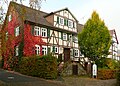
The Castle Zwesten consists of a manor house and a so-called Kavaliershaus , the former servants' quarters . The building complex on the southern outskirts was created in the 18th century as an agricultural estate. Wilhelm Treusch von Buttlar had the manor house built in 1782. The classicist building has been called a castle since a portico was built around 1915. Today the facility is used as a doctor's practice, residential building and wellness hotel.
About one kilometer northwest of the village on the Kellerwaldsteig is on the way to 368 m above sea level. NN high leak pot the "care chair", a stone with a chair-shaped seat. Symbolic worries can be dumped on it, which is made clear by the objects left by visitors in the form of an altar.
A local history museum has existed in a historic residential building in the town center since 1995. It represented the local history and presents historical furnishings of the region.
In 2000 the privately initiated Bad Zwesten Master Concerts were brought to life in Bad Zwesten. The events of the concert series with mainly classical and contemporary music usually take place in the Kurhaus or in the Hardtwaldklinik II.
At the Bad Zwesten district of Oberurff-Schiffelborn there is the castle ruin Löwenstein at 341 m above sea level. NN high elevation. Remnants of the walls, the castle fountain and a vaulted cellar have been preserved from the castle . The remains of the building were carefully secured in 2002. The keep was made accessible and is accessible as a lookout tower. It offers a wide view of the Schwalmpforte , the Urff valley and the Kellerwald-Edersee national park region .
In the Niederurff district there is a fortified church that formed a unit with Niederurff Castle. The defensive walls with loopholes and the moat have been preserved. The castle was the seat of the Lords of Urff.
The Oberurff castle located in the district Oberurff-Schiffelborn. It is a neo-baroque building that was built in 1877 by Prince Philipp von Hanau-Hořovice , the youngest son of Elector Friedrich Wilhelm von Hessen-Kassel from his morganatic marriage to Gertrude Lehmann . It has been used as a boarding school since 1952.
The Kellerwaldsteig , a circular hiking trail in the Kellerwald-Edersee Nature Park , leads through Bad Zwesten . The Barbarossaweg X8, equipped with works of art, leads past the Wenzigerode district in the north of the municipality. The artist initiative Ars Natura has also set up a circular trail (marking X8a) between Wenzigerode and the core town of Bad Zwesten as an art hiking trail.
A popular excursion destination is the Altenburg mountain ( 433 m above sea level ) on the eastern municipal border with Neuental and Borken , with the remains of the Altenburg ramparts of the same name . With an observation tower, it offers a view of Bad Zwesten, the Habichtswald , the East Hessian mountains and the Kellerwald-Edersee national park region .

Town center with town hall, behind it the Ev. church
Heimathaus with local museum

Ev. Church, formerly a fortified church with a surrounding defensive wall

Zwesten Castle
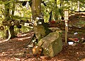
The care chair made of stone


Economy and Infrastructure
economy

Bad Zwesten has an adequate infrastructure and offers sufficient shopping opportunities.
Health resort
The upswing of Bad Zwesten as a spa and climatic health resort is based on a headwaters with several mineral springs in the southern vicinity of the village. One of the springs is used economically for the production of the Bad Zwestener Löwensprudels , another is used for drinking cures in the spa. The Zwestener Quellen are on the road to Niederurff in a park-like area, the "Kurpark am Löwensprudel". Another spa park is the spa park at the Kurhaus north of the town center.
Clinics
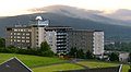
The Hardtwald Clinic I ( neurology , psychiatry , psychotherapy and psychosomatics ) and the Hardtwald Clinic II ( analytical psychotherapy , psychosomatics, behavioral therapy and psychodrama ) are located on a hill above the spa . The two specialist clinics together have around 650 beds. The Neurological Center Bad Zwesten, an acute neurological clinic, is connected to the Hardtwaldklinik I.

Kurhaus in the Kurpark

In the autumn spa park
Hardtwaldklinik I with observatory , mountain Altenburg in the background

Hardtwaldklinik II above the village


leisure
Near the village at the foot of the Altenburg mountain there is a campsite on the Schwalm , which the Camping-Club-Kassel e. V. operates. A long-distance cycle path leads past there. For canoeists, motorcyclists, cyclists and hikers, the campsite offers overnight accommodation in trekking huts . Riding lessons and guided rides are offered on the horse farm in the neighboring former wedge mill .
Soccer
The Bad Zwesten / Urfftal syndicate went out of the FC Rot-Weiß Bad Zwesten e. V. and the TSV Urfftal 08 e. V. emerged. The game community maintains several youth, men, women and senior football teams. Greatest successes: The first men's team secured the championship in the district league A2 in the 2015/16 season and thus achieved promotion to the district league. The second men's team became champions in the district league B2 in the 2015/16 season. There has been a women's team since 2013 and has played in the Northern Hesse regional league since its promotion in the 2018/19 season.
traffic
Bad Zwesten is at the intersection of federal highways 3 and 485 . To the federal highway 49 ( Kassel - Fritzlar - Marburg ) junction Borken / Bad Zwesten it is approx. Five kilometers. The community belongs to the North Hessian Transport Association , which u. a. offers a collective call taxi to Borken train station on the Main-Weser-Bahn . Bad Zwesten has been connected to the national long-distance bus network through Flixbus since July 2014 .
education
schools
There are two schools in Bad Zwesten:
- Altenburg School, Bad Zwesten (primary school)
- CJD Jugenddorf-Christophorusschule, Oberurff (secondary school and grammar school with boarding school)
Kindergartens
- Kindergarten Kasseler Straße, Bad Zwesten
- Kindergarten Betzigeröder Weg, Bad Zwesten
Personalities
- Friedrich Bachmann (1884–1961), Prussian district president and district administrator of the Biedenkopf district, born in Niederurff
- Heinrich Haupt (* 1948), former member of the state parliament
- Martin Häusling (* 1961), member of the European Parliament
- Elmar Kraushaar (* 1950), journalist
- Wolfgang Kraushaar (* 1948), political scientist
literature
- Martin Sacrifice: Zwesten: Betzigerode, Niederurff, Oberurff, Schiffelborn and Wenzigerode; Pictures and texts tell how it was back then . Wartberg-Verlag, Gudensberg-Gleichen 1989, ISBN 3-925277-31-5
Web links
- Bad Zwesten's website
- Bad Zwesten, Schwalm-Eder district. Historical local dictionary for Hessen. In: Landesgeschichtliches Informationssystem Hessen (LAGIS).
Individual evidence
- ↑ Hessian State Statistical Office: Population status on December 31, 2019 (districts and urban districts as well as municipalities, population figures based on the 2011 census) ( help ).
- ↑ a b 78th meeting of the specialist committee for health resorts, recreational areas and healing wells in Hesse on November 15, 2012 . In: State pointer for the state of Hesse . No. 7 , 2013, ISSN 0724-7885 , p. 309 .
- ↑ a b c d e Internet site of the municipality of Zwesten , accessed on May 8, 2016
- ^ Federal Statistical Office (ed.): Historical municipality directory for the Federal Republic of Germany. Name, border and key number changes in municipalities, counties and administrative districts from May 27, 1970 to December 31, 1982 . W. Kohlhammer GmbH, Stuttgart and Mainz 1983, ISBN 3-17-003263-1 , p. 392 .
- ^ Result of the municipal election on March 6, 2016. Hessian State Statistical Office, accessed in April 2016 .
- ^ Hessian State Statistical Office: Result of the municipal elections on March 27, 2011
- ^ Hessian State Statistical Office: Result of the municipal elections on March 26, 2006
- ^ Approval of a coat of arms and a flag for the community of Zwesten, district of Fritzlar-Homberg, administrative district of Kassel from September 15, 1967 . In: The Hessian Minister of the Interior (ed.): State Gazette for the State of Hesse. 1967 No. 40 , p. 1233 , point 994 ( online at the information system of the Hessian state parliament [PDF; 2.0 MB ]).

Bad Zwesten | Borken (Hessen) | Edermünde | Felsberg | Frielendorf | Fritzlar | Gilserberg | Gudensberg | Guxhagen | Homberg (Efze) | Jesberg | Knüllwald | Grains | Malsfeld | Melsungen | Rotten | Neuental | Neukirchen | Niedenstein | Upper auditorium | Ottrau | Schrecksbach | Schwalmstadt | Schwarzenborn | Spangenberg | Wobern | Willingshausen