Gadžin Han
Gadžin Han
Гаџин Хан | |
|---|---|
Town and municipality | |
| File:Opstina Gadzin Han.jpg | |
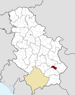
 Location of the municipality of Gadžin Han within Serbia | |
| Coordinates: 43°13′N 22°02′E / 43.217°N 22.033°E | |
| Country | |
| Region | Southern and Eastern Serbia |
| District | Nišava |
| Settlements | 34 |
| Government | |
| • Mayor | Saša Đorđević |
| Area | |
| • Municipality | 325 km2 (125 sq mi) |
| Population (2011 census)[2] | |
| • Town | 1,245 |
| • Municipality | 8,357 |
| Time zone | UTC+1 (CET) |
| • Summer (DST) | UTC+2 (CEST) |
| Postal code | 18240 |
| Area code | +381 18 |
| Car plates | NI |
Gadžin Han (Serbian Cyrillic: Гаџин Хан) is a village and municipality located in the Nišava District of the southern Serbia. According to 2011 census, a village has a population of 1,209 inhabitants, while the municipality has 8,357.
Geography
The municipality borders Bela Palanka municipality and City of Niš in the north, Babušnica municipality in the south-east, Vlasotince and Leskovac municipalities in the south, and Doljevac municipality in the west.
Settlements
Aside from the town of Gadžin Han, the municipality includes the following settlements:
- Čagrovac
- Ćelije
- Donje Dragovlje
- Donji Barbeš
- Donji Dušnik
- Duga Poljana
- Dukat
- Gadžin Han
- Gare
- Gornje Dragovlje
- Gornje Vlase
- Gornji Barbeš
- Gornji Dušnik
- Grkinja
- Jagličje
- Kaletinac
- Koprivnica
- Krastavče
- Ličje
- Mali Krčimir
- Mali Vrtop
- Marina Kutina
- Miljkovac
- Novo Selo
- Ovsinjinac
- Ravna Dubrava
- Semče
- Sopotnica
- Šebet
- Taskovići
- Toponica
- Veliki Krčimir
- Veliki Vrtop
- Vilandrica
Demographics
This article needs to be updated. (November 2011) |
Ethnic groups in the municipality (2002 census):
- Serbs = 10,170
- Roma = 179
- others.
References
- ^ "Municipalities of Serbia, 2006". Statistical Office of Serbia. Retrieved 2010-11-28.
- ^ "2011 Census of Population, Households and Dwellings in the Republic of Serbia: Comparative Overview of the Number of Population in 1948, 1953, 1961, 1971, 1981, 1991, 2002 and 2011, Data by settlements" (PDF). Statistical Office of Republic Of Serbia, Belgrade. 2014. ISBN 978-86-6161-109-4. Retrieved 2014-06-27.
See also
Wikimedia Commons has media related to Gadžin Han.


