Adorf / Vogtl.
| coat of arms | Germany map | |
|---|---|---|

|
Coordinates: 50 ° 19 ′ N , 12 ° 16 ′ E |
|
| Basic data | ||
| State : | Saxony | |
| County : | Vogtland district | |
| Height : | 494 m above sea level NHN | |
| Area : | 42.97 km 2 | |
| Residents: | 4844 (Dec. 31, 2019) | |
| Population density : | 113 inhabitants per km 2 | |
| Postal code : | 08626 | |
| Primaries : | 037423 and 037430 | |
| License plate : | V, AE, OVL, PL, RC | |
| Community key : | 14 5 23 010 | |
| City structure: | Main town, 8 districts | |
City administration address : |
Markt 1 08626 Adorf |
|
| Website : | ||
| Mayor : | Rico Schmidt ( SPD , but elected as an independent candidate) | |
| Location of the city of Adorf / Vogtl. in the Vogtland district | ||
Adorf / Vogtl. ( ) is a small town in the Saxon Vogtland district . The city is part of the Vogtland Music Corner , where musical instrument making plays a special role.
geography
Geographical location
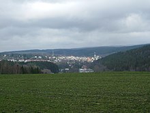
Adorf lies in the valley of the Weißen Elster at the confluence of the Schwarzbach . The town center with the market square and church is on the left above the floodplain.
Neighboring communities
Adorf borders on four municipalities in the Vogtlandkreis and in the west on the Czech Republic . In particular, these are Eichigt , Mühlental , Markneukirchen , Bad Elster and the Bohemian Hranice u Aše (German Roßbach ).
City structure
The following districts belong to the city of Adorf:
- Arnsgrün
- Getten green (upper and lower green )
- Remtengrün
- Leubetha
- Concern
- Jugelsburg
- Rebersreuth and
- Freiberg .
history
Adorf was built around 1200 on the road from Plauen to Eger . The city itself was laid out above the village in 1290. In 1294 it was mentioned as oppidum Adorph , 1328 as stat czu Ahdorf , 1461 as Adruff and 1557 as Adroff . The name of the village, which is derived from Dorf in der Aue (Aue from Middle High German ouwe , meaning land surrounded by water, island, wet meadow), was adopted.
In the Middle Ages, the city's economy benefited from the aforementioned road and another connecting road from Bohemia to Hof . In 1293 town charter was granted. From 1398 at the latest there was a mayor and a council . In 1357 Adorf fell to the Margraviate of Meißen , in 1485 to the Electorate of Saxony , in 1547 to the bailiffs of Plauen and in 1569 finally to Saxony. The Reformation began in 1522 . The place belonged to the Voigtsberg office until the 19th century .
For a long time, the city had important organ building workshops , from which the Trampeli family of organs stood out, and was formerly a "center of organ building in Central Germany".
In 1865 the city was connected to the Plauen – Cheb railway line (Cheb was then still called Eger). In 1875 the connection to Chemnitz was added via the Chemnitz – Adorf railway line . The local workers' association was founded in 1889, the local SPD group in 1906 and the local KPD group in 1919 .
During the Second World War there was a satellite camp of Stalag IV F near Adorf from 1942 . Prisoners of war of the Red Army and the US armed forces were held there at a facility of the Reichsbahn . At the end of the war in 1945, the camp was closed and the remaining prisoners of war were sent in columns towards Karlovy Vary .
On March 5, 1945, an Avro Lancaster bomber of the Royal Air Force crashed after an attack on Chemnitz between the district of Gettengrün and what was then Roßbach . All crew members, including a New Zealander, died. Today there is a memorial at the crash site. At the end of April 1945 there were also low-flying attacks and artillery fire by US troops. The aim were u. a. a branch of the Heinkel works , the Adorfer train station and other factories. Furthermore, the American soldiers fought heavy battles with members of the Wehrmacht and the Hitler Youth . On May 5th, the town's combat commander and the remaining soldiers left in the direction of Klingenthal . The city was completely occupied by the US Army on May 6 after some residents contacted them. In July, the US troops handed Adorf and the entire Vogtland over to the Soviet occupation forces . Numerous railway systems were dismantled as reparations in 1949 and brought to the Soviet Union.
Until the formation of the Vogtlandkreis in 1996, Adorf belonged to the Oelsnitz district (Kfz.-Kennz. OVL ). On August 11, 2006, the town of Adorf was named Adorf / Vogtl. around. The city is part of the cross-border association Friends in the Heart of Europe .
Incorporations
| Former parish | date | annotation |
|---|---|---|
| Arnsgrün | July 1, 1950 | |
| Freiberg | July 1, 1950 | Reclassification from Neu-Freiberg to Leubetha |
| Getten green | January 1, 1994 | |
| Jugelsburg | July 1, 1950 | |
| Leubetha | January 1, 1999 | |
| Obergettengrün | July 1, 1950 | Merger with Untergettengrün to Gettengrün |
| Rebersreuth | March 1, 1994 | |
| Remtengrün | July 1, 1950 | |
| Untergettengreen | July 1, 1950 | Merger with Obergettengrün to Gettengrün |
Population development
Development of the population (from 1960 on each December 31) :
|
|
|
|
Memorials
In the local cemetery there is a Soviet grove of honor with the graves of 13 prisoners of war as well as women and men who were abducted to Germany during the Second World War and were victims of forced labor .
politics
City council
The Adorf city council consists of 18 city councilors and the mayor. The city council election on May 26, 2019 resulted in the following distribution of seats:
| Party / group | Share of votes | Seats | +/- |
|---|---|---|---|
| CDU | 33.2% | 6th | - 2nd |
| Free Voters Adorf (FWA) | 36.3% | 7th | + 3 |
| SPD | 15.4% | 3 | - 1 |
| The left | 15.1% | 2 | ± 0 |
mayor
Rico Schmidt (SPD) has been mayor since August 1, 2011. He ran as an independent candidate and won on June 19, 2011 in the second ballot with 53.5% of the vote against incumbent Mariechen Bang (CDU). On May 27, 2018, he was confirmed in office with 96.9% of the valid votes. The turnout was 36.3%.
Coat of arms, flag, official seal
The coat of arms of the city Adorf shows in a black plate right flipped upright golden lion with red claws, open jaws and remove whipped red tongue and a thrown upward tail with two tassels.
The city's flag is gold / black striped lengthways and bears the city's coat of arms in the middle.
The official seal of the city contains the coat of arms and the inscription "Stadt Adorf / Vogtl."
Economy and Transport
Adorf is the name of the southwestern forest district of the state Saxony Forest, which includes the area of the upper Vogtland with almost 27,000 hectares of forest, but has its administrative seat in Schöneck .
Rail transport
The Adorf (Vogtl) train station is served by the Vogtlandbahn , which provides connections to Zwickau and Plauen and the Czech town of Cheb . A daily pair of trips also runs via Greiz to Gera , where they have a connection to the Intercity from / to Cologne .
Road traffic
The B 283 begins in Adorf and initially runs near the mountain ridge not far from the Czech border in a north-easterly direction via Markneukirchen to Klingenthal . Adorf is also located on the B 92 , which is part of the European route 49 .
A citizens' bus with volunteer drivers has been running in Adorf since March 2017 . For the time being, it runs every Tuesday, Thursday and Friday and connects the town with its districts and the train station.
Culture and sights
Museums
- The Freiberger Tor , the only preserved city gate in the Vogtland, houses the mother-of-pearl and local history museum with the largest mother-of-pearl exhibition in Germany.
- Adorf became known to model making friends through the miniature exhibition area Klein-Vogtland . It was opened on June 17, 1995 and exhibits a number of Vogtland sights in the form of miniature models, including the Göltzschtal bridge and the Klingenthaler round church . The exhibition also includes a LGB - garden railway and the botanical garden Adorf . The largest tufa department in Germany is located there .
- Locomotives, wagons, tools and machines are on display in the depot of the Vogtland Railway Association. The roundhouse with a turntable in front of it from 1909 offers the opportunity to view steam and diesel locomotives from the inside.
Buildings
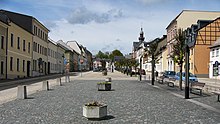
- The large, 231 m long market square was laid out in the 13th century.
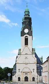
- The town church of St. Michaelis was built between 1905 and 1906, influenced by Art Nouveau.
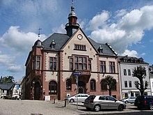
- The town hall is a neo-renaissance building from 1896.
- In the district of Remtengrün stands at 566 m above sea level. NHN a 20 m high wooden observation tower built in 1993.
- At the train station there is a locomotive shed of the Vogtland Railway Association Adorf e. V.
- The Leubetha hammer mill is the oldest hammer mill in Saxony.
music
There are two live bands in the city, “Prinzenberger” and “Vogtland Express Band”. There is also a wind orchestra in Adorf. The “Adorfer Blasmusikanten” formed from a shawm orchestra and in 2008 celebrated their 50th anniversary. An amateur choir has existed in the Gettengrün district of Adorf since 2003. Lothar Rank took over the management from the initiator and founder Siegfried Lenk.
Sports
- VFC Adorf e. V.
- ESV Lok Adorf e. V.
- 1. Badminton Club Adorf e. V.
- Budosportverein Adorf e. V.
- KC "Gut Holz" Adorf e. V.
societies
- Adorfer Carneval-Verein e. V.
- Upper Vogtland Model Railway Club e. V.
- Vogtland Railway Association Adorf e. V.
- Village and local history association Gettengrün e. V.
- Garden association “Schöne Aussicht” Adorf e. V.
- Classical Music Association Adorf / V. e. V. (the church and music association)
Companies
- The GEWA music GmbH was founded in 1925 by Georg Walther in Adorf. In the mid-1950s the company was relocated to Mittenwald / Bavaria due to the consequences of the war . After reunification, the head office was relocated back to Adorf and all operational areas were gradually merged at this location by June 2010. Today, in addition to sales subsidiaries in many important sales countries, GEWA also has substantial stakes in Asian musical instrument factories. The company, which has over 250 qualified employees, focuses on the field of mechanical-acoustic musical instruments.
Personalities
Honorary citizen
- April 1, 1895 Otto Fürst von Bismarck
sons and daughters of the town
- Johannes Adorf († 1505), theologian
- Johann Caspar von Kerll (1627–1693), organist , harpsichordist and composer
- Johann Gottlob Trampeli (1742–1812), organ builder
- Christian Gottlieb Pfretzschner (1797–1861), German educator and politician
- Carl Gotthelf Todt (1803–1852), mayor from 1832 to 1849 and member of the Committee of Seventeen
- Carl August Müller (1804–1870), instrument maker
- Johann Adam Heckel (1812–1877), instrument maker
- Ferdinand Roth (1815–1898), instrument maker, died in Milan as Ferdinando Roth
- Karl Hermann Müller-Samerberg (1869–1946), painter
- Willy Leonhardt (1880 in Arnsgrün; † in the 20th century), instrument maker
- Erich Ohser (1903–1944), known as "eoplauen"; Draftsman ( father and son ), born in Gettengrün
- Kurt Schwabe (1916–2010), archivist and regional researcher, holder of the Federal Cross of Merit and honorary citizen of the city of Grimma
- Wilhelm Lutz (* 1931), economic geographer
- Holger Heinrich Dathe (* 1945), zoologist, born in Gettengrün
literature
- Hans-Jürgen Arendt: Adorfer organ building and organ music. In: Sächsische Heimatblätter . Issue 5/1962, pp. 393-396.
- Richard Steche : Adorf. In: Descriptive representation of the older architectural and art monuments of the Kingdom of Saxony. 10th booklet: Oelsnitz official administration . CC Meinhold, Dresden 1888, p. 3.
- Adorf. In: The Upper Vogtland (= values of our homeland . Volume 26). 1st edition. Akademie Verlag, Berlin 1976, pp. 97-104.
Web links
- official homepage
- Link catalog on the subject of Adorf / Vogtland at curlie.org (formerly DMOZ )
- Adorf in the Digital Historical Directory of Saxony
Individual evidence
- ↑ Population of the Free State of Saxony by municipalities on December 31, 2019 ( help on this ).
- ^ Ernst Eichler and Hans Walther: Saxony. Old city names and their history . Faber and Faber Verlag Leipzig 2007, p. 41.
- ↑ Historical place directory of Saxony .
- ↑ About the Trampeli family of organs .
- ↑ Lausitzer Rundschau online edition of February 27, 2015 .
- ^ Report on the prisoner-of-war camp at Am Kaltenbach .
- ↑ Article on the plane crash near Gettengrün and Roßbach .
- ^ Ortschronik for the Second World War .
- ↑ Report on the city's name change to the State Statistical Office of Saxony. (PDF, 12.0 kB) Retrieved March 14, 2013 .
- ↑ StBA: Changes in the municipalities in Germany, see 1999 .
- ↑ Data source from 1998: State Statistical Office Saxony.
- ^ A b c d e Albert Schiffner : Handbook of geography, statistics and topography of the Kingdom of Saxony . Volume 1. Leipzig 1839.
- ↑ Result of the local elections in 2019. Accessed on February 22, 2020 .
- ^ Result of the mayoral election of June 19, 2011 on the website of the State Statistical Office. Retrieved March 14, 2013 .
- ↑ Main statute of the city of Adorf, § 2 deals with the coat of arms etc. (PDF; 28 kB) Retrieved on July 25, 2019 .
- ↑ Sachsenforst website , accessed on December 9, 2016
- ↑ Vogtland information - Citizen bus. Retrieved July 25, 2019 .
- ↑ Plauen online magazine: Vogtland citizens' bus association receives three minibuses - www.spitzenstadt.de. Retrieved June 16, 2017 .
- ↑ page of the railway association /
- ↑ a b Georg Dehio et al .: Handbuch der Deutschen Kunstdenkmäler . Saxony II . Deutscher Kunstverlag , Munich, Berlin 1998, pp. 1–2
- ↑ Remtengrün observation tower on adorf-vogtland.de


