
Amilly (Eure-et-Loir)
| Amilly | ||
|---|---|---|
|
||
| region | Center-Val de Loire | |
| Department | Eure-et-Loir | |
| Arrondissement | Chartres | |
| Canton | Lucé | |
| Community association | Chartres metropolis | |
| Coordinates | 48 ° 27 ' N , 1 ° 24' E | |
| height | 149-169 m | |
| surface | 20.01 km 2 | |
| Residents | 1,842 (January 1, 2017) | |
| Population density | 92 inhabitants / km 2 | |
| Post Code | 28300 | |
| INSEE code | 28006 | |
| Website | http://mairie.amilly28300.pagesperso-orange.fr/ | |

Amilly is a commune with 1,842 inhabitants (as of January 1 2017) in the department of Eure-et-Loir in the region Center-Val de Loire . It belongs to the Arrondissement of Chartres and the Canton of Lucé . The inhabitants call themselves Amilliens .
geography
Amilly is located in the metropolitan area around six kilometers west of Chartres . Amilly is surrounded by the neighboring communities of Bailleau-l'Évêque in the north, Mainvilliers in the east and northeast, Lucé in the east and southeast, Fontenay-sur-Eure in the south, Saint-Georges-sur-Eure in the southwest, Cintray in the west and Saint- Aubin-des-Bois to the west and north-west.
The former Route nationale 123 (today's D923) runs through the municipality . The municipality's train station is on the Paris – Brest railway line .
Population development
| 1793 | 1962 | 1968 | 1975 | 1982 | 1990 | 1999 | 2006 | 2012 |
|---|---|---|---|---|---|---|---|---|
| 390 | 554 | 676 | 1,168 | 1,779 | 2,098 | 1,958 | 1,904 | 1,870 |
Attractions
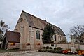
Church Saint-Pierre-Saint-Paul, in part from the 12th and 13th centuries

Parish partnership
There is a partnership with the Spanish municipality of Vilanova del Camí in Catalonia.