
Ancerville (Meuse)
| Ancerville | ||
|---|---|---|

|
|
|
| region | Grand Est | |
| Department | Meuse | |
| Arrondissement | Bar-le-Duc | |
| Canton | Ancerville (main town) | |
| Community association | Haute Saulx and Perthois-Val d'Ornois | |
| Coordinates | 48 ° 38 ' N , 5 ° 1' E | |
| height | 147-251 m | |
| surface | 21.58 km 2 | |
| Residents | 2,752 (January 1, 2017) | |
| Population density | 128 inhabitants / km 2 | |
| Post Code | 55170 | |
| INSEE code | 55010 | |
_Mairie.jpg) Mairie Ancerville |
||

Ancerville is a French commune with 2,752 inhabitants (as of January 1, 2017) in the Meuse department in the Grand Est region ( Lorraine until 2015 ). It belongs to the arrondissement Bar-le-Duc and is the capital of the canton of Ancerville .
geography
The municipality of Ancerville is located 20 kilometers southwest of Bar-le-Duc and immediately east of the city of Saint-Dizier at an altitude between 147 and 251 m above sea level. In the south of the municipality of Ancerville, the Canal entre Champagne et Bourgogne runs parallel to the Marne , which here forms the border with the Haute-Marne department .
history
The name of the place is derived from the Latin Anselmvilla , the place itself was first mentioned in 1180.
Population development
| year | 1962 | 1968 | 1975 | 1982 | 1990 | 1999 | 2007 | 2016 |
| Residents | 2362 | 2560 | 2716 | 2833 | 2869 | 2726 | 2824 | 2752 |
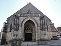
Saint Martin Church

Ancerville Castle

one of the fountains in Ancerville
_%C3%A9glise_(04)_ouest,_entr%C3%A9e.jpg)

_fontaine_avec_statue_lion_(02).jpg)
literature
- Le Patrimoine des Communes de la Meuse. Flohic Editions, Volume 1, Paris 1999, ISBN 2-84234-074-4 , pp. 35-37.