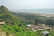
Cox's Bazar (District)
| Cox's Bazar District | |
|---|---|
 |
|
| Basic data | |
| Country | Bangladesh |
| division | Chittagong |
| Seat | Cox's Bazaar |
| surface | 2,491.9 km² |
| Residents | 2,289,990 (2011) |
| density | 919 inhabitants per km² |
| ISO 3166-2 | BD-11 |
| Website | www.coxsbazar.gov.bd |
Coordinates: 21 ° 15 ' N , 91 ° 35' E
The district of Cox’s Bazar ( Bengali : কক্সবাজার জেলা , Kaksabājār jelā ) is an administrative unit in southeastern Bangladesh , which lies within the Chittagong division . The seat of the district administration is the city of Cox's Bazar . The district has 2,289,990 inhabitants (2011 census).
geography
The 2419.85 km² district is bordered by the Chittagong district in the north and Bandarban , the River Naf and the province of Rakhine in Myanmar to the east . To the south and west lies the Bay of Bengal . The largest refugee camp in the world, the Kutupalong refugee camp , is also located in this district.
The main waters of the district are the Bakkhali , Matamuhuri , Naf and Reju Khal rivers . Several main mountain ranges run through the district from NW to SE. There are also numerous sandy beaches on the coast.
The district includes the six large islands of Kutubdia , Maheshkhali , Matarbari , Shah Pari , Sonadia and St. Martin .

Nature and wildlife
The natural vegetation consists of rainforests, deciduous forests, bamboo forests, ferns and grasslands.
Wildlife includes elephants, leopards, wild cats, wild dogs and more than 600 different species of birds. Flora and fauna resemble those of the neighboring state of Myanmar and not the Indian flora and fauna.
Agricultural areas are often created by slash and burn (Jhum in Bengali). This and soil erosion in areas with deforestation are the main reasons for the change in the landscape.
climate
The climate is subtropical and the temperatures vary between 16.1 ° C and 34.8 ° Celsius. The average annual rainfall is 4285 mm. The average humidity is usually more than 70%. There is little rain in the months from November to March. June, July and August are the months with the most rain.
history
From the 10th century onwards, the area was part of the Kingdom of Arakan . From 1666 on, local rulers paid tribute to the Mughal Empire . The weakened Mughal Empire lost the area in 1784 to the aggressive-expanding Konbaung dynasty of the Burmese . Refugees from the empire of Arakan, conquered by the Burmese, settled here. To prevent further persecution by the Burmese, the Arakanese turned to the British. They took over the area in 1799 and placed it under the Bengal Presidency , to which it belonged until 1947. From 1854 Cox's Bazar was a sub-district ( Upazila ) of the Chittagong division . Since gaining independence from the British, it was part of East Pakistan that became Bangladesh in 1971. The sub-district became a separate district (Zila) in 1984 .
population
Population development
As everywhere in Bangladesh, the population in the district has been growing rapidly for decades. The following table illustrates this:

Significant places
The most populous place within the district is the district capital Cox's Bazar . Other towns are Chakaria , Maheshkhali and Teknaf . Other places with more than 25,000 inhabitants are Kutubdia (also called Baraghop), Pekua, Ramu and Uhalapalong (also called Ukhia). The urban population makes up 21.79 percent of the total population.

administration
The district of Cox's Bazar is currently divided into seven so-called Upazilas : Cox's Bazar Sadar, Chakoria, Maheshkhali, Teknaf, Ramu, Kutubdia and Ukhia. Within this administrative subdivision there are four self-governing municipalities , 71 Union Parishads (village councils) and 989 villages.
economy
In total there are (2011) 1,020,548 people who are older than 10 years and who are not employees or self-employed. Of these, 470,687 people are in school, 22,355 people are looking for work and 527,506 people work in a household. 603,046 people are gainfully employed. Of these, 299,765 (= 49.7 percent) people work in agriculture and fishing, 47,163 in industry and 256,118 in services.
The main agricultural products are potatoes, rice, onions, legumes , garlic, wheat, sugar cane, peanuts and tobacco. The most common types of fruit are papayas, bananas, peaches, jackfruit , mangoes, litchis , coconuts and limes.
health
There is a single hospital and a health center in each subdistrict. There are also smaller health centers and family planning centers at the local level.
traffic
There is not a single railway line in the entire district. Therefore, the regional traffic is mostly handled with auto rickshaws and minibuses and the supraregional traffic with buses.