
Harvestehuder way


The Harvestehuderweg is a street in Hamburg 's Eimsbüttel district , which at the foothills of the outer Alster from the Old Rabenstraße to Klosterstern two kilometers through the districts of Rotherbaum and Harvestehude leads. With numerous free-standing villas from the late 19th and early 20th centuries, in the midst of large, partly park-like gardens, it is considered a boulevard of the Hanseatic city and, next to the Elbchaussee , as evidence of the wealth of Hamburg's merchants and entrepreneurs during the early days .
Large parts of the street are only built on one side and therefore, as far as the rich tree population allows, a view of the adjacent extensive green spaces and the Outer Alster is free. It is even more attractive due to its proximity to the city center. High prices per square meter for land, apartments and houses make Harvestehuder Weg one of the most expensive residential streets in Germany. As early as the middle of the 19th century, the street, with its first development, country houses and summer residences of wealthy Hamburg families in the then suburban area, assumed an outstanding position. In terms of building and social history, it was subject to the respective upheavals in politics and the economy, and its history reflects the rise and fall of the respective holders of power and money, the so-called pepper sacks in Hamburg .
General
Surname
The name, registered under administrative law in 1858, describes the route to the former Harvestehude monastery , which was northwest of today's oak park from 1293 to 1530. It can be traced back to the place Herwardeshude , the former location of the monastery at Pepermölenbek near the later Altona . In the literal translation, the meaning would be ferry station (Hude) of the guardian of the army (Herward), but Herward was a regionally very common name in the 12th and 13th centuries, so that the obvious assumption that a certain Herward founded the landing stage at this place , is found widely in the literature. After moving to the Alster, the nuns called their monastery “In valle virginum” (Jungfrauenthal), but the popular name remained Die Frauen von Herwardeshude , from which the name Harvestehude evolved through a linguistic change and play on words . The Hamburg story and saga writer Otto Beneke also stated that “some good people from Hamburg, since there is a Winterhude across the street, also call this Herbstehude, and not that wrong, because 'Harvest' is the Low German word for autumn.” Also The name Herbstehude is sometimes shown on old maps. Before the official name, the Harvestehuder Weg was also called Unterer Fahrweg , as a distinction to the parallel Upper ( Rothenbaumchaussee ) and Mittleren ( Mittelweg ) Fahrwege.
location

The Harvestehuder Weg is the extension of the Alsterufer road coming from the direction of Hamburg Neustadt and lies on the Geest slope of the western bank of the Outer Alster . It starts one kilometer from the city center and runs through the districts of Rotherbaum, north of the former garden house colony Fontenay , and Harvestehude, along the Pöseldorf district , to the Klosterstern. Until the beginning of the 20th century, the road was separated from the Fontenay by the confluence of the Hundebeck and the Alster; access from the direction of the city, coming from the Dammtor, was via Mittelweg and Alte Rabenstraße. The Alstervorland on the eastern side of the road with the 1953 scale Alsterpark publicly available on its entire length. The Krugkoppelbrücke at the northern end of the Outer Alster connects to the eastern districts of Winterhude and Uhlenhorst . The area west of Harvestehuder Weg is the Alsterkamp , a Geesthöhe that stretches between Isebek and Alster to Grindelberg, can still be recognized as an oval in today's city map of Hamburg through the streets Grindelallee / Edmund-Siemers-Allee and Alsterufer / Harvestehuder Weg .

Some of the properties on Harvestehuder Weg are accessed from the rear via the parallel and transverse streets of this area, such as Magdalenenstrasse, the Milky Way, Pöseldorfer Weg, Alfred-Beit-Weg, Sophienterrasse and Alsterkamp. To the north of the path is the area of the former Herwardeshude convent, which extends to the Isebek Canal and is reflected in the numerous street names in the district. In addition to Klosterstern, Klosterstieg and Klostergarten, the names Frauenthal, Jungfrauenthal and Nonnenstieg also lead to St. Benedictstraße, in honor of Saint Benedict , the patron saint of the monastery, and Heilwigstraße in memory of the founder of the monastery, Heilwig von Holstein and Schauenburg , wife by Adolf IV , goes back to this origin.
course
The Harvestehuder Weg begins in the Rotherbaum district on Alte Rabenstrasse with the pier of the same name for Alster steamers. The Alsterpark runs on the eastern side of the road over a length of well over a kilometer. The raised area on the western side of the street opposite the park is mainly developed with free-standing villas in spacious gardens from the 19th and early 20th centuries, occasionally with flat office complexes from the 1930s and 1960s and more recent residential complexes.
The Milky Way of the Pöseldorf district opens between houses number 12, today's University of Music and Theater , and number 13 . Behind the intersection with the Alsterchaussee and its extension of the ferry dam , at the level of house numbers 22 and 23, the district boundary runs between Rotherbaum and Harvestehude. In front of property number 25, Pöseldorfer Weg meets the street, at number 36 the Sophienterrasse . The street then makes a pronounced arc around the hill of the Sophienterrasse and turns in a north-westerly direction into the interior of the Harvestehude district. Here, at the end of the Alsterpark, are the first three buildings on the right-hand side of the street out of town. Behind it a road branches off to the Krugkoppelbrücke and separates the Alster foreland from the oak park. Up to this point, the portion is, due to the flat, open side of the river, and the of the path Harvestehuder wet part called, in contrast to the following dry part , which from the Alster Niederung on slightly increased Geest ground leads. After almost two hundred meters, the oak park ends with two-story apartment buildings from the 1960s.

Starting at number 57, the left side of the street is dominated by two to three-story row villas and apartment blocks from the Wilhelminian era, interspersed with row houses and more recent residential complexes. They form a closed development in sections, the front gardens are much narrower than those on the front section of Harvestehuder Weg. Behind the Licentiatenberg on the left-hand side , on which there is also a small park with old trees, Mittelweg and Frauenthal cross the street, and Hagedornstraße and, after fifty meters, the monastery garden join, so that an elongated traffic junction is formed. After the intersection of Abteistraße , the Bolivar Park is laid out on the left-hand side in the last street section . The Harvestehuder Sankt Nikolai Church is on the right-hand side of the street . Harvestehuder Weg ends after a total of two kilometers at Klosterstern , a large roundabout into which a total of six streets flow.
Demographics
Rotherbaum and especially Harvestehude are historically and currently considered to be two of the highest income and socially structurally most highly developed districts of Hamburg. The income of those liable to pay wages and income tax living here is a good twice as high as the Hamburg average. The Harvestehuder Weg with its exposed location and development has been the visible representation of the wealthy to multi-million dollar Hamburg merchant since the 19th century and, according to a survey by Capital magazine in June 2010, is the most expensive residential street in Germany. According to this, the purchase prices for single-family houses are between five and fifteen million euros, the square meter price for condominiums between 6,500 and 13,500 euros and the rental price for apartments between 22 and 24 euros per square meter. With the new building projects on Harvestehuder Weg, a further increase in the price development is planned, for example, the selling price of a condominium in the Sophienterrasse building project should be up to 15,000 euros per square meter.
Environment protection
In terms of administrative law, Harvestehuder Weg has been subject to a large number of protective provisions and restrictions since the first development plans of 1899/1906, above all the urban development conservation ordinances according to Section 172, Paragraph 1, No. 1 of the Building Code. According to the land use plan for the Free and Hanseatic City of Hamburg of October 22, 1997, it is considered a pure "residential area with two-storey open construction", as a so-called W2o area , in which limited commercial use is only intended for office buildings in exceptional ways and in compliance with the number of floors is. Furthermore, according to the landscape program including species and biotope protection program for the Free and Hanseatic City of Hamburg of July 14, 1997, “garden-related living with green quality assurance” is planned for the street , in which “open residential development with species-rich biotope elements and park-like structures” prevails. In addition, there is the Outer Alster Ordinance of March 29, 1953, according to which the areas bordering the Alster foreland are structurally uniform and the gardens must blend in with the surroundings, the view into the garden is not blocked by hedges or high fences and no external advertising is attached may be. For the rich and some very old trees, primarily Linden , Book , oaks and horse chestnuts , is also considered the Tree Protection Ordinance of the Hamburg state law of 17 September 1948. Some striking individual trees are protected status worthy of preservation .
traffic

In the section between Alter Rabenstrasse and Krugkoppelbrücke, Harvestehuder Weg was laid out in 2014 as a bicycle road. In order to limit the traffic, some places have been narrowed with marked parking spaces. In the crossing areas with the Krugkoppelbrücke and the Mittelweg it is partially expanded to four lanes, from the Mittelweg to the Klosterstern it has two lanes again. The volume of traffic is in the middle range, as the main urban traffic flow uses the parallel Mittelweg.
There are no public transport lines running through the street itself, but at the intersection of Mittelweg and Frauenthal there is a stop for the crossing bus line 19.This was used in 1974 instead of tram lines 9 and 19, which had been running along Mittelweg since 1895. The nearest underground station is the Klosterstern . Until 1984, the Alster ships also ran regular services within the Hamburg transport association . Three lines docked at the Rabenstrasse pier , and the ships on the main line also stopped at the Krugkoppelbrücke pier . There was also a connection to the Uhlenhorster ferry house on the ferry dam . Since the setting of public transport, the Alster Alster-Touristik GmbH has called Alster cruises on. The Alster steamers serve the existing jetties on the Alster foreland.
On the right side of the street out of town there are generous and separate footpaths and cycle paths along the Alsterpark; the cycle path between Alte Rabenstrasse and Krugkoppel is used in both directions, as there is no cycle traffic facility on the opposite side of the street leading into town. The footpath there is partly unpaved and completely tree-lined. From the Krugkoppelbrücke and especially at the intersection of Mittelweg / Frauenthal / Hagedornstraße there is a cycle route on both sides, which is marked with a red road surface and has its own set of traffic lights. There is no cycle path on either side between the confluence of the Klostergarten street and the Klosterstern, but cycling is partially permitted on the pedestrian paths.
history

The area that the Harvestehuder Weg runs through is characterized by the damming of the Alster in the 13th century and the Alster Lake that was formed by it. On the western bank, this is naturally bounded by an Ice Age moraine ridge of up to 20 meters high, which was heavily forested until the 15th century. The path leads between the foot of this Geesthang and the - formerly swampy and thatched - meadows facing the river. In the south, the area was bordered by the Hundebeck until the end of the 19th century , a small river that originated in Grindelwald, on what is now the university campus , and flowed into the Alster at Fontenay. In the north, the path led through what was later called Frauenthal in the direction of the Eppendorfer Baum , a ford through the Isebeck . A burial mound from the Bronze and Iron Ages , located on the corner of Mittelweg and called Licentiatenberg from the 18th century , is a visible trace of early human life on Harvestehuder Weg.
Monastery land

In the 13th century, the path connected the Heimichhude settlement north of the Hundebeck and the village of Oderfelde south of the Isebeck. These villages as well as the associated and surrounding lands, from the Alster up to and including the Grindels , the Schlumps and the Schäferkamps and in the north up to the Isebeck , belonged to the Schauenburg count Heinrich I of Holstein and Rendsburg (about 1258-1304) and were in the year Purchased in 1293 by the Herwardeshude monastery of the Cistercian Sisters near Pepermölenbeck on the Elbe , "with bushes, moors, meadows, pastures, water and all freedoms, exempt from all taxes". Two years later, in August 1295, the convent moved the monastery site from the Elbe to the Oderfelde valley, west of today's oak park. In 1310 the monastery signed a contract with the city of Hamburg, which took over its protection. In return, the nuns undertook to clear the land near the city from buildings. For reasons of defense, the area in front of the city fortress was to remain undeveloped, so the villages of Oderfelde and Heimichhude were closed. Another treaty set the Hundebeck as the border between monastery land and urban area.
The monastery existed for over three hundred years and cultivated the area on Harvestehuder Weg. The Alsterkamp , located on the western Geesthöhe, was the heartland of monastic agriculture and was used both for agriculture and for pasture for large animals, while the damp to swampy Alster foreland to the east was also used seasonally as pastureland. The road itself, as the lower road, was one of three connecting roads between the monastery and the city.
As a result of the Reformation , the convent was dissolved in 1530, the nuns were housed within the city and the monastery buildings were destroyed and demolished by decision of the council and citizens. The legal successor and new owner of the land was the St. John's Monastery in Hamburg , and a consortium set up for this purpose took over management. The area on Harvestehuder Weg was leased to the councilor Joachim Moller (1500–1558) in 1532 and continued to be used as arable land and pasture for horses, sheep and cattle. Instead of the monastery buildings, he built a leasehold and an excursion restaurant, which prompted the historian Lambecius to say: "The square is dedicated to Bacchus and has been turned into a tavern."
The construction of the Hamburg city wall between 1616 and 1625 brought about the separation of the river into the Inner and Outer Alster with the construction of the Lombard dam and bridge through the Alster and thus a significant change in the landscape. From the city, the area was now in front of the Dammtor and was commonly called But'n Dammdoor .


During the siege of Hamburg by the Danes under Christian V in 1686, the buildings of the monastery courtyard were devastated and destroyed. The then tenant of the monastery grounds, Johann Böckmann (the elder), had the inn rebuilt in 1688. At the same time, a “pleasure house for the monastery maids” was built on the part of the site on the Alster, which served as a destination for the now urban monastery members. But the area also became a popular local recreation area for other city dwellers, and in the 18th century nature walks and country walks became increasingly important. From 1703 to 1716 Bartoldo Huswedel, Licentiate of Law and President of the Hamburg Lower Court , leased the monastery inn expressly because of the value of its charming surroundings. The inn and its lime-tree beer garden became famous for both its idyllic location and the serving of "refreshing and spirited drinks". The way from the city there could be covered on the Unteren Fahrweg as a hike or via the Mittleren Fahrweg in a horse-drawn carriage. As appealing the trip across the river with the applied Ark mentioned Alster boats that were covered with a roof made of canvas and rowed. Another restaurant was opened in the 18th century at the beginning of Harvestehuder Weg, which is closer to the city and where a ferry station was also laid out. It was called De Rave , which later became The Old Raven .
Garden land
Johann Böckmann (the elder), tenant of the land and owner of the monastery inn, set up a nursery and tree nursery between 1680 and 1690 on the southern part of the Alsterkamp, between what would later become the Alte Rabenstrasse and the Milchstrasse. This was owned by the family until 1856. Opposite, in the direction of Mittelweg, the Steindorfsche Kattunfabrik was built in the 18th century , which used the meadows from the Hundebeck to the Alster as a bleaching facility. Another nursery was set up in 1717 by Johann Nicolaus Roose and Matthias Stamp in the area from the Milky Way to today's Alsterchaussee. The heirs, Otto Friedrich Rönn and Bernhard Jochim Stamp, divided up the land leased by the monastery consortium and passed it on to sub-tenants. Allotment gardens with huts for the gardeners as well as garden houses for the summer stay of townspeople were created there. According to tradition, it was said of these tenants that they “pöselt leisurely to themselves”, which means something like “they work without much success”. The name Pöseldorf, derived from this, for the spot behind Harvestehuder Weg was transferred to the growing district in the 19th century, but it never referred to an independent district with defined boundaries.
The monastery consortium disapproved of the proceedings in several letters and minutes and in 1776 signed the land as property to sixteen land users. The first classicist country houses were built there around 1800, which were used for summer stays in the undeveloped area, for example in 1795 for Senator Nicolaus Bernhard Eybe , in 1799 for Privy Councilor Martin Jacob von Faber and in 1802 for the Amsinck family . The building permit was granted on the condition that the building must be removed again if there was a risk of war. The settlement of the banks of the Alster, the gem of Hamburg's local recreation area, was viewed benevolently and critically:
“Either the lack of danger or a real sense of local decency prevented the old Hamburgers from burdening them with high stately houses and Versailles gardens. […] But the new Italian roofs and Roman villas have not been able to blur the stamp of nature around them. The observer's sensations here remain of the mild kind that the plain and the sight of a not narrow, but still river can afford. Nothing rustles here; the area only demands the heart. "
During the French occupation , the commandant, Marshal Louis-Nicolas Davout , had all settlements and buildings in the vicinity of the city fortifications burned down in 1813. This affected the entire development on Unteren Fahrweg, including the inns, and the area had "become a desert again". After the French left, the reconstruction took place relatively quickly, the old raven was furnished again and the monastery inn, much larger than before, was rebuilt in the style of a classicist country house. Böckmann's garden could also be continued soon. Johann Heinrich Böckmann (1767–1854), descendant of the first Johann Böckmann, had already bought the land from the monastery consortium in 1788 and has now divided some plots of land for development on Harvestehuder Weg.

From 1818, the St. John's Monastery, which had run into financial difficulties, sold further building sites on the Alsterkamp. The best known landowner in the northern part was the building contractor Christian Diederich Gerhard Schwieger. He laid out Schwiegerallee , which was later called Alsterchaussee, and built a country house there in 1828. Since the areas close to the city were extremely important for the city of Hamburg, which recorded a large population growth, the Senate decided to take over the magisterial rights in 1826, in 1830 the monastery lands were incorporated into the newly founded rulership of the Geestlande , Bailiwick of Rotherbaum and Bailiwick of Harvestehude were named and became an urban expansion area explained. They were parceled out and opened up with new roads. Only the leasehold remained in the possession of the monastery foundation. The site was not used for urban purposes until after the great fire of 1842. The monastery inn, which had not found a new tenant for several years, was provisionally set up as an orphanage for the homeless children. The institution existed there until 1858, when it moved to a new house on the Uhlenhorst . The former inn then served as a dragoon garrison for two years before it was finally abandoned and demolished in 1860.
Country houses and town villas
The Oberalten responsible for Harvestehude , who were important community representatives at the time, tried to prevent the sale of properties on Harvestehude Weg to private investors. In a pro-memoria pamphlet of March 19, 1838 to the Senate, it is said that “this would wither and destroy the only beautiful landscape that we still have in such close proximity to the city”. In the end they could not prevent the development, but the sale of the area on Licentiatenberg was stopped for the time being. All other properties were sold “cum conditonibus”, that is, under high conditions. The new owners had to be citizens of the city of Hamburg or the surrounding rural communities, were not allowed to operate “any kind of economy” on the property and were not allowed to fell or prune oaks and beeches without permission. The rural character was to be retained, the Alster foreland was not allowed to be built on. Building law stipulated the construction of single-family houses with front and back gardens, the construction of "small apartments, living halls and booths" was forbidden, as was the settlement of shops "which annoy the neighbors with bad smells or excessive noise". Jews were also initially excluded from purchasing the land, but this requirement was lifted again in 1842. The other provisions were incorporated in later guidelines and are still valid today in the Outer Alster Ordinance of 1953.

In addition to the construction of individual country houses, such as those of the Amsinck and Sthamer families , the development of the area was slow. In 1848 the construction of the later so-called Slomanburg as the first residential building on Harvestehuder Weg that could be inhabited all year round received public attention . In fact, it was not until the gate barrier was lifted in 1861 that the street was increasingly being built on. It received its first aqueduct in 1853, and in 1873 it was connected to the Geeststammsiel . The exit roads from the Dammtor, such as the Grindelallee and the Rote Baum , were "chaussed", that is, paved with stones, the middle path was paved up to the level of the Alsterchaussee and then turned into a sandy path. But the Harvestehuder Weg remained an “unfathomable” sandy path and “completely unlit”. Under administrative law, the two bailiffs of Rotherbaum and Harvestehude were declared suburbs in 1874 and districts of Hamburg in 1894.
After Johann Heinrich Böckmann's death in 1854, the heirs finally gave up the nursery and made the site available for further construction planning. With the construction of Magdalenenstrasse, named after Böckmann's wife Catharina Magdalena (1777–1864), and Böttgerstrasse, named after Böckmann's head gardener Elias Heinrich Böttger (1766–1847), a hinterland connection to Harvestehuder Weg was created. In the small-scale development of the Pöseldorf mainly craftsmen and "petty-bourgeois trades" settled. In accordance with this development, the streets were narrow and angled by the local owners. They were also used as rear access to the large villa plots and, as part of them, were also built on with horse stables, coachman apartments, carriage houses and locksmiths.
In the course of the development of the Rothenbaum, the Hundebeck was gradually filled in from the middle of the 19th century, and in 1908 the estuary was also built over. This made it possible to establish a connection between the Alsterufer street and Harvestehuder Weg and create a continuous connecting street on the Alster. The planning of a public road completely encircling the Alster Lake, which was taken up again in the early 1950s, was debated in this context in the citizenship as early as 1906 and demonstrated with a graphic comparison:
“We all agree that apart from the horrible climate we have, Hamburg is one of the most beautiful cities in the world. (Bravo!) Hamburg owes this beauty almost exclusively to the Alster. If we now have such a gemstone as the Alster, then we should also design the setting of this gemstone there so that the beauty of it is emphasized as far as possible. "
When the first development plan was drawn up between 1899 and 1906 for the urban expansion area that had meanwhile become part of the city, most of the properties were already built on. The main function of the plan was to “take into account the preservation of the perceptible development as much as possible.” Basically, this environmental protection is still in the current land use plans and maintenance programs.
Millionaires Street

The “suburban extension consisting almost entirely of palaces” on Harvestehuder Weg was mainly built in the last third of the 19th century and has displaced the older country houses. With the economic rise and the growing population of Hamburg, the restructuring of the city went hand in hand. The construction of the Speicherstadt not only changed the urban spaces, it also had an impact on the way the merchants lived and lived. Warehouse, office and apartment, previously under the same roof, were separated now, for the rich merchants offered the land at Harvestehuderweg highly attractive, in contrast to the also magnificently built at this time Elbchaussee in the then Prussian Altona it was in the urban district and near the city center. By 1900 almost all of the properties were built on, and the twenty-five garden houses that stood there in the mid-19th century had been demolished for new buildings or had been built over by them. In 1910 there were fifty detached villas between Alter Rabenstrasse and Licentiatenberg, another six near Eichenpark and around thirty terraced villas between Mittelweg and Klosterstern.
The social structure of the quarter was given by the building specifications, in particular the requirement to erect individual houses in garden plots. In 1911 there were 723 millionaires living in Hamburg, over half of them in the Harvestehude and Rotherbaum districts, of which around 12.5% were on Harvestehuder Weg. From the yearbook of wealth and income of millionaires from 1912 compiled by Rudolf Martin, it can be seen that almost every villa between Alter Rabenstrasse and Licentiatenberg was inhabited by a millionaire family. Most of the owners came from well-known Hamburg merchant families and were known as senators or as holders of public offices. In addition to the Slomans and Lutteroths , members of the Amsinck , Behrens , Blohm , Hudtwalcker , Krogmann , Laeisz and Robinow families lived there after the turn of the century . The writer and politician Ascan Klée Gobert wrote that the “regional Hamburg nobility lived among themselves” .
However, ownership of the real estate was subject to frequent changes; they give an image of the economic, political and social conditions in the 20th century. Until the First World War, the steadily growing wealth of Hamburg's merchants found its visible expression in the buildings on the Alster. The economic problems of the post-war period up to the Great Depression and its effects in 1930 led to the material decline of many wealthy Hamburg merchants and bankers; numerous bankruptcies were accompanied by the sale of villas and properties. There was a partial conversion of the large buildings; they were converted into multi-family houses, for office use or for representation purposes. Within the grown city, Harvestehuder Weg had moved closer to the city center and thus also became a representative address for companies and consulates.
Seat of government
From 1933 onwards, the new National Socialist rulers became interested in the area on the western Alster and in particular in Harvestehuder Weg. There were numerous expropriations and forced sales of land, especially by owners of Jewish origin or of Jewish origin, which were then taken over by state and National Socialist institutions. The desired centering of the Hamburg administration as well as the political and economic areas of power in the Reichsgau Hamburg under the leadership of the Gauleiter and Reich Governor Karl Kaufmann found a correspondence in the concentration of their residential and official seats on Harvestehuder Weg. Kaufmann set up the Gauleitung in the large villa on the Alsterufer 27. today's US consulate. For his second function, he occupied the former Budge Palais and two neighboring villas on Harvestehuder Weg with the Reich Governor; the disenfranchisement of the Jewish owners made this possible. The Reichsgaupropagandaamt , the SS group leadership , the SA upper group , departments of the Wehrmacht , the navy and an air force staff were also housed in the villas on this street, and officials from politics and business also moved into their apartments there.

The most drastic urban development change was created between 1935 and 1937 with the construction of the monumental site command for the general command of military district X near Sophienterrasse. During the Second World War, there was some destruction on Harvestehuder Weg, especially during the air raids during Operation Gomorrah on the night of July 29th to 30th, 1943, but overall relatively little war damage was recorded for this part of the city. The land around the commandant's office was particularly hard hit by destruction or damage. When the city of Hamburg was declared a fortress in April 1945 in view of the approaching Allied troops , Karl Kaufmann had the area on Harvestehuder Weg secured with a high barbed wire fence and military posts. Access was only possible via the Milky Way with a special ID. In addition to military reasons, Kaufmann saw this as a personal necessity, as he feared he would be deposed by Heinrich Himmler and Karl Dönitz .
After the end of the war, the British occupation forces confiscated the buildings previously occupied by the authorities and National Socialist institutions, as well as some private houses, including the villas of the mayor Carl Vincent Krogmann and the shipyard owner Rudolf Blohm , who was involved in the submarine construction of the Navy . Troops and military facilities were housed in the houses, some of which were also made available to new users. Beyond the occupation, the British Consulate General existed from 1956 to 2006 in No. 8a; The Anglo-German Club is still located in No. 44 .
Rebuilding

A major change in the use on Harvestehuder Weg was the construction of the Alsterpark on the occasion of the International Garden Exhibition in 1953. The necessary expropriation of private gardens of the residents in the Alster foreland goes back to an initiative of Mayor Max Brauer and became a “milestone for the cultural and social optimism of the Hanseatic City of Hamburg in the first post-war decade ”. Another change in the social structure was the conversion of the former Reich Governor into a music academy. At the same time, new buildings and complexes in the sober architecture of the 1960s were created with the rebuilding of war-torn plots and the conversion of the large villas that did not meet contemporary living ideas. The favorable inner-city location and the still prestigious address led to an influx of administrative companies, consulates, insurance companies, corporate headquarters and legal offices. The restructuring met with harsh criticism: "This street, admired all over the world, with its oaks, its gardens, its generous feeling of space, it should have remained a representative street of country houses."
Since the 1990s, there has been a renewed upheaval on Harvestehuder Weg, both in terms of how the existing structure is handled and the way it is built. On the one hand, several villas and apartment complexes were bought by investors, extensively renovated or resold or even demolished for representation purposes. There were also new construction projects that serve the upper segment of the housing market. After the German Armed Forces left their former headquarters at Sophienterrasse 14 in 2005, this 44,000 square meter property area, which extends to Harvestehuder Weg, was developed for a new residential area. Luxury townhouses were built with 40,000 square meters of gross floor area. Further exclusive apartments were built on the neighboring property at Harvestehuder Weg 36. The spacious area of the Gerling Group's office building, which was demolished at the beginning of 2010, at No. 25, at the corner of Klosterstieg, was also built on in this style.
The art historian Hermann Hipp had already described the background and the danger of this development in 1976:
“This area, which is so appealing in its overall appearance, with green facilities and road access, and with its extremely rich architecture that has become the most valuable inner-city residential area, has increasingly become a starting point for the hardware store. One tries to increase the coveted apartments by building new ones, but destroys the buildings that give the district its character. "
Along the street
Already Fritz Schumacher (1869-1947), in whose time the first design of the Harvestehuder path was largely completed as Hamburg building director (1909-1933), the architecture called on the way a "frizzy mess" because the architectural styles of the last century and a half were modeled and mixed into an adventurous style salad. Although the engineer William Lindley (1808–1900) had designed a uniform overall concept for the urban expansion area of Rotherbaum / Harvestehude around 1850, this idea did not prevail, especially on Harvestehuder Weg. The current stock shows a variety of building types, the mix of styles continued even after Schumacher's time.
architecture
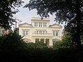
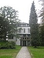
The oldest preserved monument on Harvestehuder Weg is the so-called Slomanburg , built on property no. 5 and 6 by the architect Jean David Jollasse (1810–1876) in the years 1848/1849. It is considered to be the most remarkable building of romantic historicism in Hamburg, enriched with details such as turrets, battlements and tracery from the English Tudor Gothic and characterized by the extensive gardens. In the historical context, it is the clear sign of the replacement of the modest rural garden house by the lavish country estate.


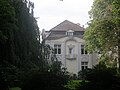
The core of the Wilhelminian style individual villas is formed by the group to the right and left of the confluence of the Milky Way, consisting of the Budge Palais (house number 12), the Villa Beit (house number 13) and the Villa Behrens (house number 14/15). All three buildings were built by the architect Martin Haller (1835–1925) between 1884 and 1899 in the neo-renaissance style; he also carried out subsequent conversions and extensions up to 1910. The former stable and farm buildings at the rear also belong to the overall ensemble of the white plastered buildings. Two other preserved villas come from Haller, the Heine-Villa, house number 41 and the Anglo-German Club with the house number 44. The sixth Haller-Villa on Harvestehuder Weg, built in 1885 for the Amsinck family at house number 20, was built in 1943 at one Bomb attack destroyed.
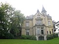
The three villas with the numbers 7a to 8a are also referred to as an exemplary group from the early days. There a development of the building types can be observed side by side, while the Villa Horschitz at number 8, built in 1872 by the architect Albert Rosengarten (1809-1893), with its belvedere , portico and triangular gable, still picks up on the classicist tradition, number 7a, built 1879 in the style of the neo-renaissance, architect unknown, especially with facing brick wall surfaces. At Villa Laeisz at number 8a, planned by Ernst Paul Dorn in 1906 , the first elements of Art Nouveau, which is rare in Hamburg, are visible , interspersed with neo-baroque forms .
References to the reform architecture can be found at Harvestehuder Weg 50 at the end of the Alsterpark. It dates from 1928, was built for Ricardo Sloman and was the first brick building on this street. It corresponds to the Krugkoppelbrücke , a few meters away, designed by Fritz Schumacher in 1927/1928 , whose three strikingly curved basket arches are made of clinker brickwork. New building with clear references to the Bauhaus is used in house number 45 on the Hoffmann and Campe site. It was built in 1930/1931 by the architect Emil Fahrenkamp (1885–1966). The General Command of the Wehrmacht on Sophienterrasse , built in 1936 by Hermann Distel (1875–1945) and August Grubitz (1876–1964), is one of the few buildings of Nazi architecture in Hamburg . It is seen as a peculiarity that, contrary to the megalomaniac buildings planned on the banks of the Elbe, this neoclassical monumental complex, hidden behind Harvestehuder Weg, can hardly develop its effect.
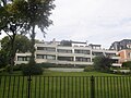
One of the incunabula of reconstruction architecture is the elongated office building designed by the architect Ferdinand Streb (1907–1970) at the beginning of the street, which was built in 1953/1954 as a whole with other buildings on Alte Rabenstraße. The multi-storey house at number 55 in the Hamburg architecture guide is described as a gruff intruder who nevertheless fits in well with the Wilhelminian style stucco villas. It was planned and executed between 1972 and 1974 by Helmut Wolff and Dieter Schlühr. In addition to two gable bulkheads and a central bulkhead, its orange-framed veranda-like porches are striking. The Hoffmann und Campe publishing house at Harvestehuder Weg 42, which was built between 1989 and 1991 and which was built by Jochem Jourdan and Bernhard Müller in the postmodern style with an eclectic character - with borrowings from classicism and the Viennese secession, is seen as another new building that has been well integrated into the surroundings - was designed.
Monument protection
There are 26 listed buildings on Harvestehuder Weg , including 20 buildings and 18 residential and office buildings: nine villas and a coach house from the 19th century, seven villas from the beginning of the 20th century, and an apartment building with its garages and outdoor facilities from the 1970s Years. Other protected buildings are the Wehrmacht General Command from 1936 at Sophienterrasse and the St. Nicolai Church from 1960/1962. The socio-topographical gradient is recognizable in the course of the street : free-standing representative individual buildings with opulent facade decorations in the midst of spacious garden plots, on the so-called “wet part” with a view of the Alster, and leading away from the Alster, in the “dry part”, smaller double or row villas with plastered fronts. Accordingly, only three of the eighteen listed residential buildings are located in this part of the street.
In addition to the buildings, the list of recognized monuments of the city of Hamburg includes another six objects in Harvestehuder Weg and its immediate vicinity. These include the Alster foreland with the Alster Park, which was created in 1953 based on the design by Gustav Lüttge, the Alte Rabenstrasse jetty, especially because of its Art Nouveau elements, an air raid shelter built in 1943 on the property at Harvestehuder Weg 10/12, a memorial for the poet Friedrich Hagedorn in the Eichenpark, a memorial plaque for Heinrich Heine on the property at Harvestehuder Weg 41 as well as the Krugkoppelbrücke created by Fritz Schumacher.
East side of the street
The eastern side of the street facing the Outer Alster has been largely owned by the City of Hamburg since the early 1950s and designed as a public space with spacious parks and jetties. The development at the end of the oak park in the direction of the Frauenthal street also took place on urban land, the houses number 78 to 84 there belong to the portfolio of the urban housing company SAGA .
Old raven
The Harvestehuder Weg begins at the Alte Rabenstraße ferry terminal , which serves as a stop for the Alster shipping and as a landing stage as well as for boat rental. A restaurant is set up there in the summer months. This place existed as early as the 18th century as a restaurant called De Rave . When it was later translated into Standard German, a mix-up of articles became Die Rabe . After another inn was opened in front of the Dammtor around 1800 as Die Neue Rabe , the name was expanded to Die Alte Rabe . It has been handed down that it was a much-visited restaurant with good cuisine, which was also easily accessible via the landing stage for Alsterarchs (boats covered with a canvas roof). With the start of shipping on the Alster in 1859, the pier became the place of operation for the ferry to St. Georg . The current jetty was built in 1909 and is a listed building, including the pontoon, wrought-iron balustrades and Art Nouveau lamps.

The road sign on the corner of Alte Rabestraße / Harvestehuder Weg was created by senior civil engineer Franz Andreas Meyer (1837–1901) as a wrought-iron construction with the figure of a raven in memory of the restaurant. The art historian Erwin Panofsky (1892–1968) reported the anecdote about this figure that the raven lost his glasses during the November Revolution of 1918. That is why “a younger friend who was inclined to joke” wrote a touching letter to the construction deputation, in which he asked for the original condition to be restored under the pretext of being an 80-year-old resident of Alte Rabenstrasse; she, the old lady, could not rest in the grave before the old raven had his glasses back. A few weeks later the glasses were reattached.
Alster foreland

With the damming of the Alster in the 13th century, the Alster foreland emerged as a swampy and often flooded meadow. It served seasonally as pasture area until the 19th century. From 1850, with the construction of new locks, the water level of the Alster was lowered by one meter; the meadows were largely drained. With the development of the plot of land on Harvestehuder Weg, the owners laid out their gardens in the Alster foreland. Development was ruled out according to the building regulations of the 19th century, which were incorporated into the Outer Alster Ordinance in 1953. As early as the end of the 19th century, the senior civil engineer Franz Andreas Meyer (1837–1901) planned a ring road around the Alster, which should allow public access to the banks; In the development plan of 1902, the Harvestehuder foreland was designated as a public green area. But it was not until Mayor Max Brauer passed a resolution in the Senate in 1950 to expropriate the small, private gardens that a public park could be created. The implementation took place in 1953 on the occasion of the International Horticultural Exhibition (IGA). According to the design of the garden architect Gustav Lüttge (1909–1968), the Harvestehuder part of the Alsterpark was laid out with a promenade, bridges, a roundabout , sculptures and a pond. The Alsterpark leads all around the Outer Alster. In the Alster foreland there are also the Alsterschifffahrt ferry docks, the Alte Rabenstrasse jetty at the beginning of Harvestehuder Weg and roughly in the middle of the Fährdamm jetty .
Oak park
The Krug coupling bridge was built at the end of the foreland in 1892 . In 1927/1928 Fritz Schumacher created the still existing reinforced concrete bridge with a brick look instead of the first wooden structure. It marks the transition from the Alster river to the Alster lake, and at the same time its access road separates the oak park from the Alster foreland. On both sides of the bridge there is another Alsterschifffahrt pier, each for one direction of travel. While the ships tie up at the part of the jetty that already belongs to Winterhude, a jetty is provided at the Eichenpark for the Alster steamers going down the river. This green area with a length of over 200 meters is located between the Alster and Harvestehuder Weg. According to its name, it is mainly occupied by English oaks . Individual trees that survived the pillage of the French era are over 200 years old. The area belonged to the site of the former Harvestehude monastery, the location of the monastery buildings in the western part is built over. A commemorative plaque contains the important dates of the history of the place. The park was laid out in 1785 on the pasture belonging to the monastery inn, the Krugkoppel, as an English landscape garden. At that time, trips to the city and to the monastery jug were very popular.
.ajb.jpg)
In 1897, after long discussions about the right location, the city of Hamburg placed a memorial stone in this park for the poet Friedrich von Hagedorn (1708–1754), because it is said to have been one of his favorite places. He dedicated the poems Ode to the Alster and Harvestehude to them . It is also known that he often sat under a certain linden tree on the Licentiatenberg, which for many years was called the hawthorn linden tree and was considered his monument.
Another memorial also took its place in the park after many years. On behalf of the Hamburg Senate, the sculptor Friedrich Wield (1880–1940), a member of the Hamburg Secession , created the bronze figure Aether Wave between 1931 and 1933 . It is reminiscent of the physicist and son of the city Heinrich Hertz (1857-1894), who in 1886 succeeded in detecting electromagnetic waves. However, the National Socialist regime prevented the installation because Hertz was a Jew. It was only on the initiative of Boris Kegel-Konietzko , the heir and administrator of Friedrich Wield's estate, that the plaster figure was restored in 1985 by the sculptor Manfred Sihle-Wissel and cast in bronze in 1987 by the Schmäke art foundry in Düsseldorf . The memorial was initially supposed to be erected in the green area in front of the NDR broadcasting center on Rothenbaumchaussee , but it wasn't until 1994 that it was placed on the banks of the Alster instead.
St. Nikolai
The Harvestehuder Nikolai Church and its parish buildings occupy the plots No. 112 to 118. The ensemble was built in the early 1960s and the church was consecrated in 1962 as the new fifth Hamburg main church as a replacement for the former St. Nikolai Church , which was destroyed in the war and served as a memorial. Church on Hopfenmarkt in downtown Hamburg. It was designed by the architects Gerhard and Dieter Langmaack , and its furnishings correspond to the old church; The altarpiece Ecce Homines (See the People) from 1974 designed by Oskar Kokoschka is a counterpart to the same mosaic in black and white in the choir of the memorial church. The large church window was designed by the glass painter Elisabeth Coester (1900–1941) for the old church but was not installed due to the war. So it found its place undamaged in the entrance hall of the current Nikolai Church. For many years the church was the meeting point of the Easter March movement.
The previous owner of the property was the senior elder Johann Jürgen Nicolas Albrecht in the 19th century. Around 1900 it was built with villas. In 1911 Otto Meyer lived in No. 114, sole owner of the Otto Meyer Jr. company. and at no. 116 the director of the Vereinsbank , Christian E. Frege.
West side of the street - Alte Rabenstrasse to the Milky Way
Böckmann garden

The Böckmann Garden existed on the property with house numbers 1 to 4 until 1856 . The Böckmann family had leased the area from the Alte Rabenstrasse to the Milky Way and used it as garden land for several generations since 1680. From the beginning of the 19th century, individual pieces of land on Harvestehuder Weg were gradually given up; the corner piece of land with the nursery buildings was the last owned by the family. Around 1880 this was also built on, a large Tudor-style house was built, which was numbered 1 to 4 as a terraced villa. The house was not in a building line with the following individual villas and was clearly pulled out to the street. Several personalities of the city lived at this address at the turn of the century, including the silk manufacturer and founder of the Father City Foundation , Johann Rudolf Warburg and his wife Bernhardine Warburg (1870–1925) and the millionaire FF Smith. During the National Socialism, the Hamburg navy department was housed in the buildings . It was destroyed in the war.
In 1953 the property was redeveloped by the architect Ferdinand Streb, with an overall design of the corner properties on Alte Rabenstrasse . A counterpart to the Iduna Germania building opposite was created , with the cubic corner building as a counterpoint to the swinging south wing. The administration building was built for Vela insurance, and Deutsche Grammophon moved into the house in the 1960s . After a renovation, the entrance was relocated, since then it has served as an office building with various tenants and can only be reached via Alte Rabenstraße 32, the address Harvestehuder Weg 1–4 has been removed.
Slomanburg

The double villa was built in 1848 on the property of the Böckmann nursery by the architect Jean David Jollasse with the number 5 for the shipowner Robert Miles Sloman (1783–1867) and with the number 6 for the merchant and senator Ascan Wilhelm Lutteroth (1783–1867 ) built. Because of its castle-like appearance with towers, stepped gables and a crenellated main cornice, it is also called Slomanburg . It was the first building on Harvestehuder Weg that was designed as the main residence:
“When my father and Mr Sloman had their villas built on Harvestehuder Weg in 1848 with the intention of occupying them in winter too, many of their friends shook their heads because, given the lack of the comfort we are used to today, a certain risk was taken to spend the winter at such a distance from the city, outside its gates with the gate lock. "
In 1911 the merchants Louis and Ad, who came from a Huguenot family, lived on the left side of the house. Th. Des Arts. As partners in Des Arts & Co., both belonged to the richest families in Hamburg. Louis Des Arts was the owner of this part of the building. The right half of the house belonged to another millionaire, the magistrate Martin Anton Popert. The entire villa has been a listed building since 1972.
Horschitz villas
The properties of house numbers 7 and 8 were parceled out several times towards the end of the 19th century , so that the intermediate numbers a and b were assigned in the official numbering. The Sthamer family's country house was built on property no. 7 in 1852 . In 1883 Robert Miles Sloman Jr. took over. (1812–1900) the site and had a villa built for all year round. In 1890 he left this to his daughter Stefani Brödermann (1848–1945), who lived there until her death and in 1911 was considered one of the richest women in the city. Around 1970 the property was rebuilt together with the neighboring property No. 7a with an apartment house. The Consulate General of Chile is located next to the apartment. The site still belongs to the heirs of the Sloman family.
Plots No. 7a, 7b and 8 belonged to the Doormann family in the middle of the 19th century, who had their country house there. The merchant Sally Horschitz (1822–1883) acquired it around 1870 and had a villa built in the classicist tradition with a belvedere, portico and triangular gable at No. 8 by the architect Albert Rosengarten . As early as 1879 he sold the house again and had another villa built on the left side at no. 7 b. Property 7a was also built on in 1879, where the captain and businessman Johannes Lühmann lived. In 1921 he had to file for bankruptcy and sell the villa. In 1890 the Prussian embassy moved into house no.7b, and in 1912 the older Villa Horschitz no.8 was added. From 1921 to 1945 the city of Hamburg took over all three villas for the regional finance office.
After the war, the authority was limited to building 7b, in 1967 it moved to Harvestehuder Weg 14. House no. 7a was demolished around 1970 and built over together with property no. The Horschitz Villa at No. 8 was in the public interest from 2000 onwards due to expensive renovations and multiple sales.

House No. 7: Sthamer's country house around 1850

House no.8: Doormann's country house around 1850
House No. 7 and 7a, since 1970

House no.7b: Villa Horschitz II from 1879
House No. 8: Villa Horschitz from 1872


Villa Laeisz
The property with house number 8a was acquired by the shipowner Carl Laeisz (1828–1901) in 1870. After his death, the widow Sophie Laeisz (1831–1912) had the villa built by the architect Ernst Paul Dorn in 1905/1906 , it was to become her retirement home. The building is considered a restrained Art Nouveau style, overlaid by late Baroque forms and emphasizes the center of the house facade with its structure of columns and balconies. The pavilion-like porches are seen as reminiscent of the architect Martin Haller.
After Sophie Laeisz's death, the villa remained in the family's property for two years and was occupied by her grandson Erich Laeisz (1888–1958), heir to the shipping company. In 1914 the businessman Hermann Fölsch, who had become rich in the Chilean saltpeter business, took over the house. Between 1920 and 1923 he had the architect Georg Radel carry out extensive renovations. In 1928 the house passed to the son Conrad Johann Fölsch. The stock market crash of 1929 led to the collapse of the Fölsch company, the company had to be liquidated in 1930, the furnishings of the house as well as numerous antiques, collectibles and art objects were auctioned off in June 1931. The house itself could apparently be kept for the time being, Conrad Fölsch lived there until 1934.
In April 1934, the villa was the conformist bought Hamburg Senate, the circumstances suggest that it was a forced sale, the purchase price was 115,000 Reichsmarks instead of the estimated value of 238,000 Reichsmarks. The purchase took place on the orders of the SS (Upper Section North-West), which took over the house and set up its office there. This procedure was legally covered by an order from the Reich Minister of Finance of March 3, 1934, according to which state and public buildings had to be given to the NSDAP and its branches. Numerous conversions and extensions were carried out up to 1945, from 1942 onwards with the use of prisoners from the Neuengamme concentration camp .
After the capture of Hamburg, British troops confiscated buildings and initially used them as storage rooms and clothing stores. In 1949, the State Commissioner and later British Consul General John K. Dunlop had it set up as a “residential and guest house for his own purposes”. In 1952, he expanded the house for the British Consulate General , which resided there until 2006 , with a further renovation . In 1986 the building was placed under monument protection. In May 2008, Sal. Oppenheim Private Bank took over the villa.
Music college


In the middle of the 19th century, the country houses of the Hamburg families HA Hellmrich, S. Albrecht and Robert Miles Sloman were located on the land at house numbers 10 to 12. Lot No. 11 was built on in 1872 with a villa, in which the millionaire S. Löwenstein and later the interior designer Kurt Clavier lived. In 1884 the architect Martin Haller built a house for the ship broker Ivan Gans on plot No. 12. Henry (1840–1927) and Emma Budge (1852–1937) bought it around 1900 and had Haller expand it into what would later become the Budge Palais . The middle, two-storey wing and the two outer wings with bay windows are still visible from Villa Gans. On the side of the Alster, the building was extended with the semicircular central projections and the steep roofs. In the years 1909/1910 a hall extension was added to the rear, which was set up as a mirror hall and served private theater and music performances. Property no. 10 was built on in 1910 for Hermann Blohm (1848–1930), the founder of the Blohm + Voss shipyard ; To distinguish it from other buildings by the Blohm family on Harvestehuder Weg, the building was called Villa Blohm I.
These three villas became the official and residence of the Hamburg governor Karl Kaufmann during the National Socialist era; In his second function as Gauleiter, he resided in the large villa on Am Alsterufer 27, today's American Consulate General . In 1935 Kaufmann bought the villa from the Blohm family at No. 10 and set up an administration building there. He then made an offer to buy Emma Budge, which she refused. After her death in 1937, the city of Hamburg took possession of the house by putting pressure on the Jewish heirs and executors. The last will of Emma Budge was disregarded, who in her will revoked the agreement negotiated with the then State Councilor Leo Lippmann in 1932 to donate the house to the city after the National Socialists came to power and expressly decreed that the house would not become the property of Hamburg may. The last occupants of the villa, Henry Budge's nephew Siegfried Budge (1869–1941) and his wife Ella Budge (1875–1943), had to leave the house after the transfer of ownership, both of whom died during further persecution by the National Socialists.
The owner of house no. 11, Kurt Clavier, wanted to sell his house to the Egyptian consulate in 1938, but was refused the necessary permit. Instead, the Hamburg property management company took the villa under trust and sold it to the city of Hamburg in 1939 at a significantly reduced price. Clavier's fortune was provided with a security order by the regional finance directorate in accordance with the Foreign Exchange Act; Clavier managed to emigrate to South Africa.
The Reichsstatthalterei moved into the Budge-Palais in 1938 (the villas on lots 10 and 11 were included in the complex as administrative wings and staff houses). In 1939/1940 Kaufmann had a bunker set up for himself and his staff on the rear property between numbers 10 and 11. This was placed under monument protection in April 2010.

In 1945 the British troops confiscated the three buildings and occupied them until 1955. House No. 10 was used for a period of forensic medicine. In a redress procedure, the executor Emma Budges, appointed by the National Socialists and not deposed after 1945, negotiated a settlement with the city of Hamburg on the Harvestehuder Weg 12 property complex, without the heirs living in the USA being notified. On November 10, 1952, following a ruling by the Hamburg Regional Court, the Budge-Palais including the ancillary properties was sold to the city for an additional payment of DM 22,500.
The Budge Palais has been used by the University of Music and Theater since 1959 . The former Blohm Villa in 1960 and the former Clavier Villa in 1964 were demolished to expand them, and the Hall of Mirrors built in 1909 was demolished. Its interior was housed in the Museum of Arts and Crafts and was reconstructed there in 1986. The extensions to the music college were built between 1969 and 1982 based on designs by the architect Fritz Trautwein (1911–1993). In 1974 the artist Jan Meyer-Rogge created the sculpture Dreiklang made of light metal, which is installed in front of the former house number 11. Since 1993 a bronze plaque at the entrance to the Milky Way has been commemorating Henry and Emma Budge, and in summer 2007 two stumbling blocks were placed in the sidewalk to commemorate Ella and Siegfried Budge .
West side of the street - Milky Way to Klosterstern
Villa Beit and Villa Behrens

In the middle of the 19th century, the plots No. 13 to 15 were partly built on with country houses belonging to well-known Hamburg families. The summer house of the merchant Johann Friedrich Carl Refardt sen. (1800–1871), which he had bought in 1848. In 1890/1891 the architect Martin Haller built an imposing house for Johanna Beit, the widow of the chemist Ferdinand Beit (1817–1870). After her death, her son Ferdinand Beit jun. (1858–1928) the villa. Particularly noteworthy about this building are the coach house and the farm buildings with numerous turrets and porches in the courtyard of the entrance area on the Milky Way, which is known as cour d'honneur .

No. 14 was a house built in 1845 by the architect Alexis de Chateauneuf for Frau von Hess, née Hudtwalcker, and No. 15 belonged to the merchant C. F. Michahelles. As early as 1866, Haller built a house for the merchant Jaffé on property No. 14. The banker Eduard L. Behrens bought it in 1896 together with the neighboring property No. 15. Haller was commissioned to expand and merge the buildings. An elongated building was created that is reminiscent of a palace complex. Together with the Budge-Palais, this row of large, white-plastered villas by the architect Haller is the epitome of Alster architecture. The owners, Beit and Behrens, were among the richest families in Hamburg until the Nazi era. They were considered generous patrons and provided material and non-material support for the expansion of the art gallery and the university . They were assimilated Jews, baptized Protestants, and in some cases related by marriage to other Hamburg merchant families and related by marriage. In particular, because of their economic and political activities, they belonged to the Hamburg oligarchy . After the takeover of power, the National Socialists intervened in the financial situation, both the Beit heirs and the Behrens family had to sell their properties and villas on Harvestehuder Weg to the city of Hamburg. Employees of the Reich Governor's Office moved into Villa Beit, and Villa Behrens was occupied by the Wehrmacht from 1939.
After the war, the British confiscated the villas, and until 1950 it housed a British officers' mess. From 1952, Olympic Maritime , a shipping company in the empire of Aristotle Onassis , resided in No. 13 ; the house was rebuilt for their purposes by the architect Caesar Pinnau . In 1967, the regional tax office moved into villa No. 14. Both villas were in the late 1990s by the fashion designer Jil Sander acquired in the no. 14 fashion company Jil Sander Collection GmbH housed. The houses, including their outbuildings and coach houses, have been under monument protection since 1993.
Country houses Eybe and Amsinck
The plots with house numbers 18 to 20 have the longest building history in the former garden land. The architect Johann August Arens built a country house for Senator Nicolaus Bernhard Eybe (1749–1821) at No. 18/19 in 1795/1796 and a country house for the family of des in 1802 on the neighboring property No. 20 Hamburg Mayor Wilhelm Amsinck (1752–1831). His father Paul Amsinck (1714–1777) had already acquired the property in 1776. Both houses were destroyed in 1813 during the French era and then rebuilt. Around 1850 the country houses of the sons Wilhelm Eybe (1783–1852), also a senator, and Johannes Amsinck (1792–1879), a merchant, were in the same place .
Land nos. 18 and 19 were parceled out at the end of the 19th century, and two villas were built. In 1911, the lawyer Wilhelm Anton Riedemann , co-founder of the German-American Petroleum Society, lived in No. 18 and Gerhard Bruns, partner in the timber import company Goßmann & Jürgens and co-founder of the Hamburg Scientific Foundation, lived in No. 19 . In 1925, Rudolf Blohm took over plot No. 19 and built a villa on it, the so-called Villa Blohm II. Because of its involvement in the National Socialist armaments policy, this house was confiscated by the British occupying forces in 1945. It was converted into an apartment building in the 1950s. Prominent tenants were Gustaf Gründgens and Oscar Fritz Schuh . Lot number 19 was also rebuilt around 1930. There was a two-story brick office building with a high column entrance, which is still used today. Among other things, the container leasing company of former Senator for Economic Affairs Ian Karan has its headquarters here.
Property no. 20 remained in the possession of the Amsinck family. In 1885 Martin Haller built a representative villa for the shipowner Martin Garlieb Amsinck (1831–1905) instead of the old country house. After Martin Amsinck's death, his daughter Clara and his son-in-law, who later became mayor of Hamburg, Max Predöhl (1854–1923), moved into the house. During the Second World War, the building was destroyed in a bomb attack. In 1953 a large classicist villa was built there, which housed the French consulate until 2004.

No. 18–19: Landhaus Eybe, around 1850

No. 20: Landhaus Amsinck, around 1850

No. 18: office building, since 1930
No. 19: Villa Blohm II, since 1925

No. 20: French Consulate from 1953 to 2004


Sophienterrasse
The site of the northern Alsterkamp, between Harvestehuder Weg, Mittelweg and Klosterstieg, was bought in 1818 by the building contractor Christian Diederich Gerhard Schwieger from the St. Johanniskloster Foundation. He parceled out the part south of the Sophienterrasse and sold the individual pieces of land, now number 27 to 36.


Land No. 27 was bought in 1830 by Senator Ami de Chapeaurouge , who commissioned the architect Alexis de Chateauneuf to build a country house. In 1894 the diamond dealer Alfred Beit (1853–1906) took over the site, had the old house demolished and a new villa built. After his death, his mother, Laura Beit (1824–1918) lived in the house. In 1928 the property was rebuilt again, the Jewish Kommerzienrat Schöndorff had a large house built with an imposing, oak-paneled staircase. But he lived only briefly in this place, after his forced resignation from the Supervisory Board of Karstadt AG on March 29, 1933, he emigrated. The house was taken over by the Hamburg SA upper group under Herbert Fust . After the war ended, the British secret police moved into the building. In 1966 it was torn down and the property was rebuilt with apartment-style apartment buildings. A prominent resident of one of the apartments was the actor Harry Meyen . In 1962 a small street was laid out in the rear part of the property, with which, among other things, property No. 28 is developed; it was named Alfred-Beit-Straße in memory of the previous owner .
From 1860 the merchant and later consul Julius Friedrich Wilhelm Reimers was the owner of the plots no. 28 to 36, which reached up to the Mittelweg. In 1861 he laid out a private road for development and named it Sophienterrasse after his wife Maria Sophie Frederica Reimers (1826–1918) . At the later house number 30, he had the Villa Sophia , a “palatial building reinforced with battlements”.
After 1900 the area was parceled out again; Erich Laeisz bought property no. 28 and built a villa there from 1915 to 1921, which he called the “house of his dreams”. It was destroyed in a bombing raid in 1944, as were the riding arena, coach houses and garages in the rear of the property. In 1964 the Wilhelm-Gymnasium was built on this site . Christina Mitzlaff-Laeisz, Erich Laeisz's daughter, had a new house built on her father's property in 1963. When the new access road was opened, it was given the address Alfred-Beit-Straße 8.
Lot No. 36 was built with a villa in 1920 by Otto Blohm (1870–1944), a cousin of Walter and Rudolf Blohm, and his wife Magdalene (1879–1952), called Villa Blohm III to distinguish it . The house was damaged in the war, but could still be inhabited. In the 1960s, Allianz insurance was housed there. In 1965 the house was demolished and the area was built with apartment houses. In 2009 the investment company Peach Property Group AG took over this property. She plans to demolish the apartments and build five four-story buildings with a total of 63 condominiums in the top price segment.

The large central part of the site with the Villa Sophia was bought by the German Reich in 1935 and a site command and various farm buildings were built on. The general command of the military district X. of the Wehrmacht was housed there. The drafts for this extensive building complex with a monumental three-wing complex and a central projection arranged by strict pillars came from the architects Distel & Grubitz. The Villa Sophia was occupied by the commander of the X. Army Corps, General Wilhelm Bonehauer (1878–1939), from 1939 to 1945 the Sophienterrasse was called General-Bone-Hauer-Strasse . After the war, the British troops were housed in the military area; from 1956 to 2005 the Bundeswehr headquarters in Hamburg was housed there.
When the Bundeswehr moved out, the approximately 7.6 hectare property became interesting for urban planning. In 2006 Frankonia Eurobau Investment acquired the area for an estimated purchase price of between 35 and 40 million euros. According to the development plan adopted in January 2008 for the Sophienterrassen construction project in the Eimsbüttel district, around 200 residential units in townhouses, around 6,000 square meters of office space and around 420 underground parking spaces are to be created with the help of the listed site headquarters. The master plan for the site between Mittelweg and Harvestehuder Weg comes from the Hamburg architect Mirjana Markovic (MRLV Architects). The wing of the former headquarters building has been gutted and is to be given a new use with apartments. Parts of the interior design of the facility are to be carried out by the fashion designer Karl Lagerfeld . On Harvestehuder Weg, Frankonia built five more residential buildings, each with several apartments. With a direct reference to the Alster, there are two sandstone-clad townhouses by Mirjana Markovic at house numbers 29 and 33, and behind them with house numbers 30 to 32 are three classicist houses by Petra and Paul Kahlfeldt , Berlin.
Hoffmann and Campe
The Hoffmann and Campe publishing complex has been located on lots 41 to 45 since the post-war period . It consists of four individual houses with different histories and architecture. No. 41 was the former Villa Krogmann , it was built in 1878 by the architect Martin Haller for the Krogmann family. It is an unusual brick building for the Alster architecture with a gable crown in the Renaissance style. The heir Carl Vincent Krogmann was mayor of Hamburg during the Nazi era, and he set up the house as a Reichsgaupropaganda office. The house was confiscated by the British occupying forces in 1945 and assigned to Hoffmann und Campe Verlag by the British military authorities as a publishing house in place of their old premises, which had been destroyed in the war. The bronze Heinrich Heine plaque created by the sculptor Caesar Heinemann was placed next to the building in 1959 . It was unveiled for the first time in front of the old publishing house in 1898 and dismantled and hidden during National Socialism. This makes it the only original memorial to the poet that survived the Nazi era. The former house of Mayor Krogmann has been called the Heine Villa ever since .
In the course of the following years the publishing house gradually bought the neighboring houses and land. No. 43 is a classicist white villa built in 1873. From 1935 to 1945 the consul and chairman of the Hamburg Ship Brokers Association, Guido Caulier-Eimbcke, and his son-in-law, the geographer and explorer Otto Schulz-Kampfhenkel, resided there . Building No. 45 is a red brick cube from 1930/1931 with a clear Bauhaus reference. It was designed by the architect Emil Fahrenkamp for Walter Kruspig , the general director of Rhenania-Ossag . A new publishing house was built on property no. 42 from 1989 to 1991, architects were Jochem Jourdan and Bernhard Müller. The style is described as eclectic postmodernism , which mixes classicist motifs, borrowed from the Vienna Secession and which fitted sensitively both between the old-style villas and the tree-lined grounds.
No. 41: Heine-Villa

Heine badge between No. 41 and 43
No. 42: publishing house

No. 43

No. 45: House Kruspig


Licentiatenberg and Bolivar Park

The Licentiatenberg is opposite the Eichenpark on the left-hand side of the street out of town, before the confluence of Mittelweg and Harvestehuder Weg. It is the visible and undeveloped extension of the Geesthöhe of the Alsterkamp and is raised by a Bronze Age grave. This green area also has old trees, with the oldest oak Harvestehudes, around 450 years old. It is said to have got its name from an interim tenant of the monastery inn, Bartoldo (Barthold) Huswedel, at the beginning of the 18th century, who was a licentiate of rights and president of the lower court in Hamburg . There is a connection with the megalithic grave in the Hamburg district of Großborstel, also known as Licentiatenberg, to the extent that the nuns of the monastery also went there on excursions and the Großborsteler Hügel was called Jungfernberg until the 19th century . Another explanation for the more common name is that these places were given permission to speak law, corresponding to the meaning of the Latin word licentiat .
The Bolivar Park is at the end of Harvestehuder Weg between Abteistraße and Klosterstern and stretches west to Rothenbaumchaussee. In its strikingly rising terrain you can still see the pit in which sand and gravel were mined until the 19th century. In snowy winters it is a designated toboggan run. The structure of the site meant that the property was removed from Harvestehude's development plans and created as a park around 1900. It was initially called Abteipark after the neighboring street . In 1960, the newly established Republic of Venezuela donated a monument to the city of Hamburg to the South American independence fighter Simón Bolívar (1783-1830). The southern exit of the abbey park was chosen as the location, which was renamed Bolivar Park on this occasion.
Works of art along the street
Along the Harvestehuder Weg, especially in the green areas, but also in the front gardens of the properties, there are a large number of monuments and works of art. Most of them date from around 1960 and are integrated into the Alsterpark concept as art in public space . The following list contains the most eye-catching works of art and a former work of art:
| Location | Artist | description | Illustration |
|---|---|---|---|
| Alte Rabenstrasse / Harvestehuder Weg |
Franz Andreas Meyer | Street sign with a wrought-iron raven figure, entered on the list of recognized monuments |
 |
| House number 1 Alte Rabenstr. 32 | Jean Sprenger (1912–1980) | Bronze sculpture from 1955 on the green area in front of the office building at the corner of Alte Rabenstrasse, formerly the administration building of Iduna Germania / Signal-Iduna ; entered in the ensemble with the building on the list of recognized monuments. The figure represents the Germanic youth goddess Idun . She is in the front garden of Alte Rabenstr. 32 on the Harvestehuder Weg side - hidden behind bushes on the left. |
 |
| Alster foreland | Gustav Seitz | Bronze sculpture: The kneeling woman , 1962 |
 |
| Alster foreland | Manfred Ritthoff-Lienau | Sculpture graffiti: The metamorphic bank of Mr. Lienau and other welded plate sculptures by the artist on the banks of the Alster |
 |
| Alster foreland | Thomas Stricker | Concrete sculpture: Meteorite Workshop , 2000 |
 |
| Alster foreland | Ursula Querner | Bronze sculpture: Orpheus and Eurydice , 1958 |
 |
| Alster foreland | Jörn Pfab | Bronze sculpture: tall standing woman , 1958 |
 |
| Alster foreland | Gerhard Brandes | Bronze sculpture: flying a kite , 1963 |
 |
| House number 11 | Jan Meyer-Rogge | Light metal sculpture: Dreiklang , 1974 |
 |
| House number 39 | John Seward Johnson II | Sculpture: One man's search and other works by Johnson in the front garden of the villa |
 |
| House number 41 | Caesar Heinemann | Bronze plaque: Heinrich Heine , 1898, monument, entered on the list of recognized monuments |
 |
| Oak park | unknown | Bronze relief : Friedrich Hagedorn , 1897, memorial plaque embedded in a boulder, entered on the list of recognized monuments |
 |
| Oak park | Friedrich Wield | Bronze sculpture: ether waves , 1933; Monument to Heinrich Hertz - This sculpture has been standing in front of the NDR radio station on Rothenbaumchaussee since 2016 |
 |
| House number 107 | Hugo Lederer | Sculpture: Destiny , 1905; This sculpture stood in this place until 1956, in its own small pavilion in the garden of the former Villa Lippert; the house was torn down and the figure was placed in the Ohlsdorf cemetery near Chapel 7. |
 |
| Bolivar Park | L. Frizzi | Bronze sculpture: Simon Bolivar , 1960; Monument, gift from the Republic of Venezuela to the city of Hamburg, entered on the list of recognized monuments |
 |
literature
- Michael Ahrens: The British Consulate General on Harvestehuder Weg. Hamburg 2003, OCLC 249041882 .
- Christian Hanke, Reinhard Hentschel: Harvestehude - Rotherbaum in transition. Hamburg 1993, ISBN 3-929229-09-9 .
- Arno Herzig (Ed.): The Jews in Hamburg from 1590 to 1990. Scientific contributions by the University of Hamburg to the exhibition Four hundred years of Jews in Hamburg. Hamburg 1991, ISBN 3-926174-25-0 .
- Hermann Hipp : Harvestehude - Rotherbaum. Workbooks on the preservation of monuments in Hamburg No. 3. Hans Christians Verlag, Hamburg 1976, ISBN 3-7672-0425-8 .
- Felix Rexhausen : In Harvestehude. Notes from a Hamburg district writer. Hamburg 1979, ISBN 3-920610-26-1 .
- Wilhelm Schwarz: But'n Dammdoor. From the past of the Hamburg district Harvestehude-Rotherbaum. Hamburg around 1930.
- Silke Urbanski : History of the Harvestehude Monastery “In valle virginum”. Economic, social and political development of a nunnery near Hamburg 1245–1530. (Dissertation). Münster 1996, ISBN 3-8258-2758-5 .
- Eberhard Wiese: Here is paradise. Fates on Harvestehuder Weg. In: Eberhard von Wiese: Hamburg. People - destinies. Frankfurt 1967.
- Jonas Ludwig von Heß : Hamburg described topographically, politically and historically , Volume 3, Verlag (the author), 1811, Die alte Rabe and Harvestehude from page 55 full text at InternetArchive.
Web links
- Homepage St. Johannis Monastery , accessed on September 30, 2010.
- Klaus Mühlfried: Architecture as an Expression of Political Sentiment - Martin Haller and his Work in Hamburg (2005) (PDF; 8.2 MB), accessed on September 30, 2010.
- Free and Hanseatic City of Hamburg: Landscape Program. New residential area east of Mittelweg in Harvestehude (PDF; 1.0 MB), accessed on September 30, 2010.
- Citizens' initiative Sophienterrasse with numerous links to development plans, administrative status, procedural status and press articles on the development on Sophienterrasse and Harvestehuder Weg, accessed on September 30, 2010.
- Hamburg Tourismus: Art between Central Station and Alster (PDF), accessed on September 30, 2010.
References and comments
- ↑ a b Otto Beneke: The old Harvestehude . In: Hamburg stories and legends. Hamburg 1886. No. 27 ( Wikisource )
- ↑ Statistics Office North: Income 2004, query with comparative figures ( page no longer available , search in web archives ) Info: The link was automatically marked as defective. Please check the link according to the instructions and then remove this notice. , accessed September 13, 2010.
- ↑ Capital, article from June 17, 2010 in immobilien-kompass.de , accessed on September 25, 2010.
- ↑ a b More and more excavators are rolling into Harvestehuder Weg. In: In: Die Welt , March 16, 2010.
- ↑ § 172 Paragraph 1 No. 1 Building Code in dejure.org
- ^ Outer Alster Ordinance of March 29, 1953 , accessed on September 29, 2010.
- ↑ a b Development plan for Harvestehude 13 (PDF; 205 kB), accessed on September 27, 2010.
- ↑ Lutz Achilles et al. a .: When people still drove trams in Harvestehude , publisher: Verein Verkehrsamateure und Museumsbahn e. V., Hamburg 2001, p. 14 and p. 42.
- ↑ Christian Hanke, Reinhard Hentschel: Harvestehude - Rotherbaum im Wandel , Hamburg 1993, p. 4.
- ^ Wilhelm Schwarz: But'n Dammdoor. From the past of the Hamburg district Harvestehude-Rotherbaum , Hamburg around 1930, p. 5.
- ↑ Silke Urbanski: History of the Harvestehude Monastery "In valle virginum". Economic, social and political development of a nunnery near Hamburg 1245–1530 , Münster 1996, p. 21 ff.
- ^ Werner von Melle: Moller, Joachim . In: Allgemeine Deutsche Biographie (ADB). Volume 22, Duncker & Humblot, Leipzig 1885, p. 125.
- ↑ Peter Lambeck, quoted from: Wilhelm Schwarz: But'n Dammdoor. From the past of the Hamburg district Harvestehude-Rotherbaum , Hamburg around 1930, p. 8.
- ^ Christian Hanke: Hamburgs street names tell history , Hamburg 2006, ISBN 3-929229-41-2 , p. 189.
- ^ Otto Ruths: Pöseldorf. In: Elisabeth Rickwardt: Pöseldorf. An illustrated book , Hamburg 1966, p. XII
- ^ Hermann Hipp: Harvestehude - Rotherbaum. Workbooks on the preservation of monuments in Hamburg No. 3 , Hans Christians Verlag, Hamburg 1976, p. 13.
- ^ Jonas Ludwig von Heß: Hamburg, described topographically, politically and historically , 1810, quoted from Hermann Hipp: Harvestehude - Rotherbaum , p. 13.
- ^ Hermann Hipp: Harvestehude - Rotherbaum , p. 14.
- ↑ ICW Wendt, CEL Kappelhoff: Hamburg's Past and Present , Volume II (1896), facsimile print, Hamburg 1980, p. 543.
- ↑ Christian Hanke, Reinhard Hentschel: Harvestehude - Rotherbaum im Wandel , Hamburg 1993, p. 20.
- ^ Hermann Hipp: Harvestehude - Rotherbaum , p. 17.
- ^ Wilhelm Schwarz: But'n Dammdoor. From the past of the Hamburg district Harvestehude-Rotherbaum , Hamburg around 1930, p. 21.
- ^ Hermann Hipp: Harvestehude - Rotherbaum , p. 18.
- ^ Johann Berenberg Gossler, minutes of the citizenship meeting on March 21, 1906; quoted from: Hermann Hipp: Harvestehude - Rotherbaum , p. 50.
- ^ Template for the draft of the development plan from 1906, quoted from: Hermann Hipp: Harvestehude - Rotherbaum , p. 50.
- ^ A b Hermann Hipp: Harvestehude - Rotherbaum. P. 58.
- ^ Rudolf Martin: Yearbook of the wealth and income of the millionaires in the three Hanseatic cities , Berlin 1912.
- ^ Christian Hanke, Reinhard Hentschel: Harvestehude - Rotherbaum im Wandel , Hamburg 1993, p. 23.
- ^ Alfons Bauer, Reinhard Münster, Volker Sonnenschein: Cityscape Hamburg. Harvestehude. Milieu area analysis , Hamburg 1987, p. 8.
- ↑ Uwe Lohalm: "Model Hamburg". From city-state to Reichsgau. In: Hamburg in the “Third Reich”. P. 125 f.
- ↑ Hamburger Unterwelten: Kaufmann-Bunker , accessed on September 25, 2010.
- ^ HO Dieter Schoppe: The Alsterpark. A garden monument from the 1950s . In: Frank P. Hesse u. a .: What use is a beautiful garden to me? Published by the Patriotic Society and the Association of Friends of Monument Preservation, Hamburg 1990, p. 97.
- ↑ Alfons Bauer, Reihard Muenster, Volker Sunshine: cityscape Hamburg. Harvestehude. Milieu area analysis , Hamburg 1987, p. 23.
- ↑ a b Eberhard von Wiese: The beautiful Älsterpark. In: Hamburger Abendblatt. September 10, 1960.
- ↑ Better living on the Alster - the building boom in the magnificent villas. In: Die Welt , January 27, 2000.
- ^ From the concrete gold of the Nazis sueddeutsche.de of October 19, 2013
- ^ Hermann Hipp: Harvestehude - Rotherbaum , p. 8.
- ^ Hermann Hipp: Harvestehude - Rotherbaum , p. 57.
- ^ Hermann Hipp: Harvestehude - Rotherbaum , p. 59.
- ^ A b Hermann Hipp: Harvestehude - Rotherbaum , p. 81.
- ^ Ralf Lange: Architekturführer Hamburg , Stuttgart 1995, p. 130; The term incunabula comes from the Latin incunabula and means “diapers, cradle”, it was originally used for the letterpress typefaces that were created before 1500, and later also in art and architecture for works that were created early in a style and are trend-setting.
- ↑ Ralf Lange: Architekturführer Hamburg , Stuttgart 1995, p. 134.
- ↑ Hamburg Monument Protection Office: Recognized monuments F – K (PDF; 1.9 MB) accessed on September 13, 2010.
- ^ Wilhelm Schwarz: But'n Dammdoor. From the past of the Hamburg district Harvestehude-Rotherbaum , Hamburg around 1930, p. 25.
- ^ Martin Warnke: Art history as art; from: In memory of Erwin Panofsky (1892–1968). Speeches on the occasion of the naming of lecture hall C in the main building of the University of Hamburg in the Erwin-Panofsky-Hörsaal on June 20, 2000. Hamburg University Speeches New Volume 17, Hamburg 2000, p. 45 Full text edition of the Hamburg University Library (PDF; 313 kB) accessed on 29 September 2010.
- ↑ Hamburg, New City on the Elbe - Urban Development, Green and Transport Planning, p. 108 Full text edition of the University Library Hamburg ( page no longer available , search in web archives ) Info: The link was automatically marked as defective. Please check the link according to the instructions and then remove this notice. (PDF; 56 kB) accessed on September 29, 2010.
- ^ Friedrich von Hagedorn: Harvestehude. In: Poetic Works, Theil 4, Bern 1770, p. 201 ff. (Die Alster) and p. 203 ff. (Harvestehude); fully accessible as google book , accessed on September 27, 2010.
- ^ Wilhelm Schwarz: But'n Dammdoor. From the past of the Hamburg district Harvestehude-Rotherbaum , Hamburg around 1930, p. 30 f.
- ↑ Portrait of the Schmäke foundry ( page no longer available , search in web archives ) Info: The link was automatically marked as defective. Please check the link according to the instructions and then remove this notice. , accessed October 13, 2010.
- ^ Information from Boris-Kegel-Konietzko
- ↑ Maike Bruhns: Art in the Crisis. Volume 2: Künstlerlexikon Hamburg 1933–1945 , Hamburg 2001, ISBN 3-933374-95-2 , pp. 408–413.
- ^ Forum on Church Education , accessed on September 30, 2010.
- ^ A b c d e Rudolf Martin: Yearbook of the wealth and income of the millionaires in the three Hanseatic cities , Berlin 1912.
- ↑ Partial development plan 21 from April 2, 1953 ( page no longer available , search in web archives ) Info: The link was automatically marked as defective. Please check the link according to the instructions and then remove this notice. (PDF; 2.7 MB) accessed on October 1, 2010.
- ↑ Arno Herzig (Ed.): The Jews in Hamburg from 1590 to 1990 , Hamburg 1991, p. 451 f.
- ↑ Werner Skrentny (Ed.): Hamburg on foot. 20 district tours, revised edition. Hamburg 1992, ISBN 3-87975-619-8 , p. 238.
- ↑ a b c d e f Ralf Lange: Architekturführer Hamburg , Stuttgart 1995, ISBN 3-930698-58-7 also as a google book
- ^ Arthur Lutteroth: Harvestehude sixty years ago , lecture at the Association for Hamburg History on October 17, 1910; Lütcke & Wulff, Hamburg 1910.
- ^ Genealogy of the Horschitz family
- ↑ Rainer Horn: A Alsterperle in new splendor. In: Hamburger Abendblatt. July 1, 2006, accessed September 25, 2010.
- ^ The Laeisz family , accessed September 25, 2010.
- ↑ Michael Ahrens: The British Consulate General on Harvestehuder Weg , Hamburg 2003, p. 28.
- ↑ Michael Ahrens: The British Consulate General on Harvestehuder Weg , Hamburg 2003, p. 32 ff.
- ↑ Sal. Oppenheim press release of May 21, 2008 ( Memento of the original of August 24, 2009 in the Internet Archive ) Info: The archive link has been inserted automatically and has not yet been checked. Please check the original and archive link according to the instructions and then remove this notice. (PDF; 55 kB) accessed on September 25, 2010.
- ↑ Arno Herzig (Ed.): The Jews in Hamburg from 1590 to 1990 , Hamburg 1991, p. 658 f.
- ↑ hagalil.com hagalil.com: Two “stumbling blocks” in front of the Budge Palais, accessed on September 25, 2010.
- ^ Frank Bajohr : Aryanization in Hamburg. The displacement of Jewish entrepreneurs 1933–1945 , Hamburg 1997, pp. 271 f., 293 f.
- ↑ Arno Herzig (Ed.): The Jews in Hamburg from 1590 to 1990 , Hamburg 1991, p. 664.
- ↑ German Gender Book, Volume 51, p. 354.
- ↑ Arno Herzig (Ed.): The Jews in Hamburg from 1590 to 1990 , Hamburg 1991, p. 419 ff.
- ↑ Hamburgisches Architekturarchiv ( Memento from July 19, 2012 in the web archive archive.today ), accessed on September 25, 2010.
- ^ Frank Bajohr: Aryanization in Hamburg. The displacement of Jewish entrepreneurs 1933–1945 , Hamburg 1997, p. 55.
- ↑ Eberhard von Wiese: Here is paradise. Fates on Harvestehuder Weg , Frankfurt 1967, p. 42.
- ↑ This is how Harry Meyen, darling of women, died ( memento from July 30, 2012 in the web archive archive.today ), Hamburger Abendblatt from April 17, 1979. Accessed on September 1, 2010.
- ↑ a b The house numbering has changed in the course of the development of the Harvestehuder Weg. Today the rear apartment block of No. 27 is called No. 28. From around 1900 to 1963, the house at Alfred-Beit-Straße 8, which has since been accessible via the access road, was No. 28, previously it was No. 27a. Before 1900 the later number 30 (Villa Sophia) was number 28.
- ^ Hermann Hipp: Harvestehude - Rotherbaum , p. 17; Christian Hanke: Hamburg's street names tell history , Hamburg 2006, p. 190.
- ↑ Eberhard von Wiese: Here is paradise. Fates on Harvestehuder Weg , Frankfurt 1967, p. 31.
- ^ Homepage Wilhelm Gymnasium: History of the Gymnasium , accessed on September 26, 2010.
- ↑ Peach Property press release from September 22, 2009 ( page no longer available , search in web archives ) Info: The link was automatically marked as defective. Please check the link according to the instructions and then remove this notice. (PDF) accessed on September 29, 2010.
- ↑ 300 new apartments on Sophienterrasse , HA from May 30, 2006 , accessed on July 29, 2015
- ↑ Conrad Bauer-Schlichtegroll: Ideas for millions of projects. The new Emporio building and the luxury apartments on the Sophienterrasse are currently being built according to plans by MRLV Architekten. In: Hamburger Abendblatt. December 11, 2010, accessed November 2, 2014 .
- ↑ kleinezeitung.at: fashion designer Karl Lagerfeld designs luxury villas in Hamburg. kleinezeitung.at, February 17, 2009, archived from the original on October 20, 2014 .
- ↑ Werner Skrentny (Ed.): Hamburg on foot. 20 district tours, revised edition. Hamburg 1992, p. 242.
- ↑ Harald Vieth: Hamburg trees. Contemporary witnesses of the city's history. Self-published, Hamburg 1996, ISBN 3-930961-95-4 .
- ↑ Christian Hanke: Hamburgs street names tell history , Hamburg 2006, p. 130: Licentiat: provided with permission.
- ↑ Allocation plan for the area of the monastery inn and the leasehold Harvestehude, drawn up by the geometer AAM Nagel, October 22, 1859. In: Hermann Hipp: Harvestehude - Rotherbaum. P. 28.
- ↑ The mysterious sculpture man. In: Die Welt , September 7, 2009.
- ^ Project exhibition field service , accessed on September 30, 2010.
- ↑ L'esprit d'escalier: Tyche pulls us by our heads , accessed on September 30, 2010.
Coordinates: 53 ° 34 '26.7 " N , 9 ° 59' 57.4" E