
Essen / Oldenburg
| coat of arms | Germany map | |
|---|---|---|

|
Coordinates: 52 ° 43 ' N , 7 ° 56' E |
|
| Basic data | ||
| State : | Lower Saxony | |
| County : | Cloppenburg | |
| Height : | 26 m above sea level NHN | |
| Area : | 98.02 km 2 | |
| Residents: | 9078 (Dec. 31, 2019) | |
| Population density : | 93 inhabitants per km 2 | |
| Postal code : | 49632 | |
| Primaries : | 05434, 05438 | |
| License plate : | CLP | |
| Community key : | 03 4 53 006 | |
| Community structure: | 19 districts | |
| Address of the municipal administration: |
Peterstrasse 7 49632 Essen / Oldenburg |
|
| Website : | ||
| Mayor : | Heiner Kressmann | |
| Location of the municipality of Essen / Oldenburg in the district of Cloppenburg | ||
  |
||

Essen / Oldenburg is a municipality and a town in the Cloppenburg district in Lower Saxony . It consists of 18 farmers or districts and the village of Essen as the center. The hare flows through the community.
The part of the name Oldenburg refers to the Oldenburger Land and serves to distinguish it from Essen, Ruhr . The stylization is done with a slash and the official abbreviation is Essen / Oldb.
geography
Geographical location
Essen still belongs to the geographic landscape of Artland , but to the north it also borders the Cloppenburger Geest . This means that the community lies within the North German Plain on the northern foothills of the Artland alluvial plain , "an extensive flatness that is only weakly subdivided by valley sand slabs and damp lowlands" and on the southern tip of the Cloppenburger Geest an "arable, largely open, poorly structured cultural landscape which is used heavily for agriculture and has a very small proportion of forest ". The municipality is traversed by the northern arms of the Hase , which forms an inland delta in this area . The main arm of the Hase, which flows through the area of the municipality of Essen, is called the "Essen Canal" above the confluence of the Hase camp , and below it the "Great Hase". Despite the name “Lager Hase”, the so-called river, which borders the center of Essen in the south, does not carry any water from the Osnabrück area with it. Rather, it drains the center of the Vechta district , especially the cities of Vechta , Lohne and Dinklage . The actual Hase reaches the Hase camp two kilometers west of the Essen town center.
Districts

The following districts are part of Essen: Addrup (298), Ahausen (144), Barlage (74), Bartmannsholte (242), Beverdiek (11), Bevern (714), Bokel (10), Brokstreek (447), Calhorn (168) , Darrel (32), Essen-Ort (incl.Ostendorfe) (4015), Felde (128), Gut Lage (32), Herbergen (181), Hülsenmoor (1300), Nordholte / Stadtholte (43), Easter food (302) , Sandloh (85), Uptloh (345) (the population figures in brackets).
climate

There is a moderate maritime climate influenced by wet north-westerly winds from the North Sea. On a long-term average, the air temperature in Essen reaches 8.5 to 9.0 ° C and around 700 mm of precipitation falls. Between May and August, an average of 20-25 summer days (climatological term for days on which the maximum temperature exceeds 25 ° C) can be expected.
Neighboring communities
The neighboring communities are Lastrup and Cappeln (Oldenburg) in the north, Bakum in the east , Artland in the south, Löningen in the west and Dinklage in the south-east .
history
The Essen municipality looks back on a history spanning more than 1000 years. Clear finds from the Younger Stone Age (3000–1800 BC) indicate a settlement in the area of the community. In the farming communities of Bartmannsholte and Uptloh from the State Museum for Natural History and Prehistory in Oldenburg, rich Neolithic material (vessels, flat axes and flint arrowheads) was found in a hill.
The grave fields in the districts of Herbergen, Ahausen and in the area around Nordholte and Calhorn also provide information about the existence of prehistoric people in the municipality.

Based on the place and field names as well as written records, it can be seen that there were several settlements in the Essen district in the early Middle Ages . Essen was mentioned in a document from the year 968, according to which the wife of Alaburg or Altburg of Count Heinrich, who had his residence at Arkenoa Castle (Arkenau) in Brokstreek, had a basilica built in Essen. In another document, Simon , Count von Tecklenburg announced that a Benedictine monastery was to be founded. The Benedictine nuns' monastery, founded around 1157, burned down in 1194. The monastery was then re-established as Malgarten Monastery . Essen remained with the County of Tecklenburg until 1400 and after the peace treaty with Count Nikolaus II of Tecklenburg came to the bishopric of Münster . In the middle of the 15th century the aristocratic estates Velthaus, Groß- and Klein-Arkenstede, Vehr, Lage and Calhorn were established.
The furnishings of Meierhöfen (large supplement, Crone-Münzebrock, Richthof) also date from the time of Charlemagne, under which the Münsterland was divided into Gaue . For Hasegau were eating, Löningen , Lastrup , alleviating , Menslage and Borg (today part of Menslage).
At the time of the Reformation under Bishop Franz von Waldeck, Essen was dominated by Lutherans for around 70 years from 1543 to 1613. At that time, the Protestant reformer Hermann Bonnus worked in this region . In the course of the Counter Reformation under Bishop Ferdinand of Bavaria , the region was re-Catholicized.
The great fire in Essen in 1601 cremated half the village. The church, school and chaplain also burned down and the church was provisionally rebuilt. As a result of the Thirty Years' War and its side effects (plague in 1659, smallpox in 1661), life in the community almost died out. In 1651 Essen only had 685 inhabitants; In 1703 there were about 3000 inhabitants.
In 1803, the Münster office of Cloppenburg and with it the municipality of Essen and its then almost exclusively Catholic residents were added to the Duchy of Oldenburg .

Under Pastor Meyer, the new construction of the current Catholic parish church of St. Bartolomäus began in 1870, and the construction was completed in 1875 under Pastor Möhlmann. In this year the municipality of Essen was connected to the Oldenburg Südbahn (Oldenburg-Quakenbrück). In 1888 the Essen – Löningen line was opened to traffic and Essen became a railway junction.
The First and Second World Wars again tore large gaps in the community's population. With the influx of evacuees and (including evangelicals) expellees from the east , the congregation experienced an upturn that has not been recorded to date. At the end of 1949 the number of refugees was 2691 out of a total population of 8476, or 31.7 percent. After the Hengelage was incorporated into Quakenbrück in 1972, the community of Essen had 6,790 inhabitants.
In the last ten years there has been an increase in the influx of repatriates . Today around 9,000 people live in the community.
On July 1, 1972, a sub-area was ceded to the town of Quakenbrück in the district of Osnabrück as a result of the regional reform in Lower Saxony, which at that time had significantly more than 1000 inhabitants (Hengelage) .
politics
Municipal council
The Essen municipality council consists of 22 councilors and councilors. This is the specified number for a municipality with a population between 8001 and 9000 inhabitants. The 22 council members are elected for five years each by local elections. The current term of office began on November 1, 2016 and ends on October 31, 2021.
The full-time mayor Heinrich Kreßmann is also entitled to vote in the municipal council.
The local election on September 11, 2016 resulted in the following:
| Political party | 11th September 2016 | September 11, 2011 | ||
|---|---|---|---|---|
| CDU | 71.74% | 16 seats | 76.68% | 17 seats |
| SPD | 28.25% | 6 seats | 18.17% | 4 seats |
| The green | - | - | 5.15% | 1 seat |
| voter turnout | ||||
| 60.29% | 55.65% | |||
mayor
In the last mayoral election on September 11, 2011, the incumbent Georg Kettmann was re-elected with 84.61% (2004: 91.28%) of the vote. The turnout was 55.65% (2004: 40.12%). In the mayoral election on September 11, 2016, none of the candidates achieved an absolute majority. Therefore, on September 25, 2016, a runoff election took place between the CDU candidate Clemens Große Macke (38.2%) and the non-party Heinrich Kreßmann (31.7%), which Kreßmann won.
coat of arms
Description of coat of arms:
- Shield divided. Above a golden six-pointed star in a red field, below a red sea leaf in a silver field.
- The six-pointed pointed star was borrowed from the coat of arms of the von Pennethe family , who founded the estate and provided many castle men in Quakenbrück and Vechta .
The red sea leaf comes from the coat of arms of the Counts of Tecklenburg . Historiography assumes that the oldest verifiable castle complex in Essen was founded by the Counts of Tecklenburg, whose coat of arms contained three sea leaves or broken linden leaves.
Partner communities
Essen (Oldenburg) maintains an international partnership with the municipality of Essen (Belgium) . The first contact goes back to a visit by the then mayor of the Flemish municipality of the same name in 1968. In the meantime, partnership documents have been exchanged. Visits take place regularly.
Attractions
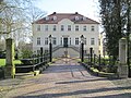
Worth seeing are the town hall in Art Nouveau style and renovated windmill "Diekmann mill". Furthermore, the former noble estate "Gut Lage" and the altar of the St. Bartholomew Church and the recently renovated train station on the Oldenburg Southern Railway . The sandstone sculpture “im river” by Bramsch sculptor Regine Meyer zu Strohe stands on the banks of the Lager Hase as part of the sculpture path Hasetal Art Route .

Town hall (Villa August Meyer)

Half-timbered house (formerly Hotel zur Post)

Diekmann's mill
Good location (manor house)

Sculpture "in the river"
_urbodomo.jpg)
_trabfaka_domo_2.jpg)
_muelejo.jpg)


Economy and Infrastructure

traffic
The federal road 68 used to lead directly through the center of Essen. However, on July 15, 2008, a planning approval procedure was initiated for the construction of a bypass road, which had been under construction since 2012 and was finally opened to traffic on October 12, 2015. About 17 kilometers away junction Vechta of A 1 , the community is connected to the motorway network.
Essen (Oldb) train station is on the Oldenburg – Osnabrück railway line ; the RE 18 (Osnabrück - Oldenburg - Wilhelmshaven) stops every hour. The operation on the railway line is carried out by the NordWestBahn . Furthermore, the railway to Meppen branches off in Essen , it has freight trains and museum railroad traffic.
Essen is on the 265 km long Hase-Ems-Tour cycle path . You can cycle or hike up the Hare to the source at Melle , and down the Hare to the mouth of the Meppen . The hare can be used by canoeists .
Established businesses
Economically, agriculture and the processing of its products dominate the municipality . In Essen, for example, there are important companies for the production of food and animal feed, such as Germany's fourth largest slaughterhouse and meat cutting company (formerly D&S Fleisch , now part of Danish Crown ) and the Wernsing group in the Addrup farmers' community .
There are also various international companies in the mechanical engineering and home accessories industries in Essen.
education

There are three kindergartens in the municipality: the municipal kindergarten Regenbogen , the Catholic Kindergarten St. Josef and the Catholic Kindergarten St. Marien in the Bevern district. There are also two day nurseries for children under three in Essen.
Essen has three schools: the 3/4-speed Reliable Primary School Essen, which is to be run as an all-day school from August 2010 , the ½-speed Reliable Primary School in Bevern and the Oberschule as an all-day school in Essen.
Personalities
Sons and daughters of the church
- Franz Hülskamp (born March 14, 1833 in Essen, † April 10, 1911 in Münster ), Catholic clergyman, editor, literary and political organizer in various Catholic associations and the German Center Party
- Amandus Bahlmann OFM (born May 8, 1862 in the Bartmannsholte peasantry; † March 5, 1939 in Naples ), Catholic clergyman, bishop and founder of an order in Brazil
- Lambert Meyer (born January 29, 1855 in Essen in Oldenburg; † February 2, 1933 in Vechta), priest and episcopal official of the Münster diocese in Oldenburg
- August Crone-Münzebrock (born May 17, 1882 on the Münzebrock farm in the Ahausen farm; † April 17, 1947 in Osnabrück), German peasant leader and politician ( German Center Party )
- Bernhard Eckholt (born November 2, 1887 in Brokstreek; † March 12, 1949 in Cloppenburg), German farmer and politician (German Center Party, NSDAP)
- Hilarius Albers OP (civil Theoder Wilhelm Albers, born October 30, 1899 in Essen / Oldenburg, † February 14, 1971 in Berlin), Dominican priest
- Aurelius Arkenau O.P. (* January 7, 1900 in Essen; † October 19, 1991 in Bedburg-Kirchherten ), Catholic clergyman and opponent of the Nazi regime
- Johannes Schütte (1913–1971), Roman Catholic clergyman and superior general of the Steyler missionaries
- Otto Neteler (* 1936), football player
- Clemens Große Macke (born July 19, 1959 in Addrup), farmer, management consultant and politician (CDU), member of the Lower Saxony state parliament since 2003
Other personalities related to food
- Maria Brand (1877–1956) was the first female member of the Oldenburg state parliament .
- Klaus von Klitzing , born on June 28, 1943 in Schroda / Posen, grew up in Essen (Oldb), 1985 Nobel Prize for Physics on the subject of " Quantum Hall Effect "
- Heinrich Große Beilage (1885–1955), farmer, lawyer and politician, member of the state parliament (CNBL)
Web links
- Homepage of the community
- Homepage of Addrup
- Homepage of the Bartmannsholte farmers' association
- Homepage of the Brokstreek farmers
- Essen-Oldb at medieval genealogy.
- [1]
Individual evidence
- ↑ State Office for Statistics Lower Saxony, LSN-Online regional database, Table 12411: Update of the population, as of December 31, 2019 ( help ).
- ↑ Essen municipal administration: Mayor. Retrieved May 9, 2020 .
- ↑ Municipality of Essen / Oldenburg: main statute. (PDF) Accessed on July 21, 2020 : "§ 1 Name and legal status The municipality bears the name" Gemeinde Essen / Oldenburg ". The community name can be used in the abbreviated form "Gemeinde Essen / Oldb."
- ^ Kuhlmann: The Artland and the city of Quakenbrück in their historical development. P. 7.
- ↑ Federal Agency for Nature Conservation, Cloppenburger Geest landscape profile ( Memento of the original from April 19, 2014 in the Internet Archive ) Info: The archive link was inserted automatically and has not yet been checked. Please check the original and archive link according to the instructions and then remove this notice.
- ↑ Website of the municipality of Essen (Oldb)
- ^ Federal Statistical Office (ed.): Historical municipality directory for the Federal Republic of Germany. Name, border and key number changes in municipalities, counties and administrative districts from May 27, 1970 to December 31, 1982 . W. Kohlhammer GmbH, Stuttgart / Mainz 1983, ISBN 3-17-003263-1 , p. 275 .
- ^ Lower Saxony Municipal Constitutional Law (NKomVG) in the version of December 17, 2010; Section 46 - Number of MPs , accessed on January 29, 2017.
- ↑ Municipality of Essen - municipal council election 2016 , accessed on January 29, 2017
- ↑ Otto Gruber: The coats of arms of the South Oldenburg nobility . In: Yearbook for the Oldenburger Münsterland 1971 . Vechta 1970, p. 25
- ↑ Franz Hellbernd: Münsterländische castles and noble houses , 1963 ( Memento of 19 April 2014 Internet Archive )
- ↑ Lower Saxony Mühlenstrasse: Diekmanns Mühle
- ↑ District of Cloppenburg: Monument in focus - manor house Gut Lage Dinklagerstraße, Gut Lage, municipality of Essen ( Memento from December 17, 2011 in the Internet Archive )
- ^ Lower Saxony State Archives: Gut Lage
- ↑ Lower Saxony State Authority for Road Construction and Transport: Essen bypass in the course of Bundesstraße 68
- ↑ Essen bypass in the course of Bundesstraße 68. Lower Saxony State Authority for Road Construction and Transport, October 12, 2015, accessed on October 17, 2015 (project page).
- ↑ Bernhard Hachmöller: Meyer, Franz Lambert In: Hans Friedl u. a. (Ed.): Biographical manual for the history of the state of Oldenburg . Edited on behalf of the Oldenburg landscape. Isensee, Oldenburg 1992, ISBN 3-89442-135-5 , pp. 458-460 ( online ).
Barßel | Evil | Cappeln (Oldenburg) | Cloppenburg | Emstek | Essen / Oldenburg | Friesoythe | Garrel | Lastrup | Lindern (Oldenburg) | Loeningen | Molbergen | Saterland