Fours (Gironde)
| Fours | ||
|---|---|---|
|
|
||
| region | Nouvelle-Aquitaine | |
| Department | Gironde | |
| Arrondissement | Blaye | |
| Canton | L'Estuaire | |
| Community association | Blaye | |
| Coordinates | 45 ° 10 ′ N , 0 ° 38 ′ W | |
| height | 0-33 m | |
| surface | 4.64 km 2 | |
| Residents | 318 (January 1, 2017) | |
| Population density | 69 inhabitants / km 2 | |
| Post Code | 33390 | |
| INSEE code | 33172 | |
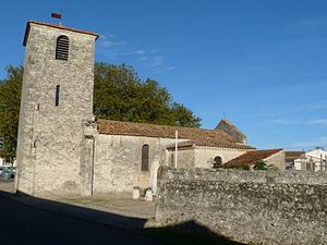
 Parish Church of Saint-Louis |
||
Fours is a French municipality with 318 inhabitants (at January 1, 2017) in the department of Gironde in the region Nouvelle-Aquitaine . It belongs to the arrondissement and the canton of L'Estuaire .
geography
The municipality of Fours borders the Gironde to the west .
Population development
| year | 1962 | 1968 | 1975 | 1982 | 1990 | 1999 | 2006 | 2017 |
| Residents | 241 | 208 | 195 | 252 | 250 | 279 | 285 | 318 |
Attractions
- Parish Church of Saint-Louis
literature
- Le Patrimoine des Communes de la Gironde. Flohic Éditions, Volume 1, Paris 2001, ISBN 2-84234-125-2 , pp. 225-226.
Web links
Commons : Fours - collection of images, videos and audio files
