
Île de Groix
|
Groix Groe |
||
|---|---|---|
.svg)
|
|
|
| region | Brittany | |
| Department | Morbihan | |
| Arrondissement | Lorient | |
| Canton | Lorient-2 | |
| Community association | Lorient agglomeration | |
| Coordinates | 47 ° 38 ′ N , 3 ° 27 ′ W | |
| height | 0-48 m | |
| surface | 14.82 km 2 | |
| Residents | 2,263 (January 1, 2017) | |
| Population density | 153 inhabitants / km 2 | |
| Post Code | 56590 | |
| INSEE code | 56069 | |
| Website | http://www.groix.fr/ | |
 Map of the island |
||

The Ile de Groix [ il də ɡʁwa ] ( Breton : Enez Groe ) is a 2.5 km wide and 6 km long French island in the department of Morbihan in the region of Brittany . It is located eight kilometers south of Lorient in Brittany. Their beacons serve as navigation aids for ships.
The island is identical to the municipality of Groix , which has 2263 inhabitants (as of January 1, 2017). It was the only municipality in the canton of the same name that existed until 2015 . Since March 2015, she has been part of the newly founded canton Lorient-2 .
Until 1940 Groix was France's most important tuna port . In the capital Le Bourg, a tuna adorns the church tower of the Église Saint-Tudy .
A rarity in Europe is the Plage des Grands Sables ( the large sandy beach ), a fine sandy, about 500 m long convex beach.
geology
The Île de Groix belongs to the Armorican massif and is therefore a tiny part of the collision zone between the great continents Gondwana and Laurussia , which united in the Carboniferous to form the great continent Pangea (→ Variscan orogeny ). Rocks emerge all over the island, including the Pointe des Chats reserve , which were formed more than 300 million years ago by metamorphosis deep in the earth's crust and which are stored in other parts of Europe beneath thick layers . It is mainly mica slate and chlorite slate as well as amphibolite and blue slate .
history

The dolmen Men Kam and Men Yann, which are typical for Brittany, are two of the gallery tombs that are located on Groix. The Men Yann dolmen (also known as Men Yeun) is 100 meters from the coast, on a hill overlooking Port-Saint-Nicolas and the Kerlard Valley. It is surrounded by the remains of its hill about 10.0 m in diameter. The Men Kam Dolmen (Eng. "The limping stone") is about 50 meters away. It still has a dozen bearing stones over a length of around 10.0 meters. Its hill is partially preserved. Gallery tombs, dolmens and menhirs have been preserved on the island. The V-shaped dolmens and the Allées couvertes date to the 4th millennium BC. Chr.
- Allée couverte de Kerloret
- Allée couverte by Kerrohet
- Allée couverte du Storang
- Dolmen Men Kam and Men Yann
- Port-Mélite dolmen
- Butten er Harh (Dolmen)
- Dolmen du Gripp
- Vagouar-Huen dolmen
- Kerloret menhir
- Men Hoal Menhir
- Menhir de Clavezic
- Menhir de Fort Grognon
- Menhir de Quelhuit
- Mez Kergatouarn menhir couché
On the island was also a ship grave of Viking excavated. In addition to game pieces made from walrus bones , it contained the incomplete remains of an adult woman without grave goods. Similar find connections were made in Ballateare and Balladoole on the Isle of Man . Against this background, it is assumed that the bones can be assigned to a victim. The custom of considering the burial with sacrificed slaves is documented in Haithabu and Oseberg (Norway).
From 1944 the German Navy maintained a naval hospital on the island .
- Attractions
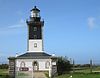
Phare de Pen-Men lighthouse

A tuna shows the wind direction on the Église Saint-Tudy

Port Tudy harbor

Port Tudy lighthouse


literature
- Le Patrimoine des Communes du Morbihan. Flohic Editions, Volume 1, Paris 1996, ISBN 2-84234-009-4 , pp. 353-359.
- Claude Audren, Claude Triboulet, L. Chauris, JP Lefort, J. Vigneresse, J. Audrain, D. Thiéblemont, J. Goyallon, P. Jégouzo, P. Guennoc, C. Augris, A. Carn: Notice explicative. To: Carte géologique de la France à 1/25 000. Feuille 415: Ile de Groix. Bureau de Recherches Géologiques et Minières, Orléans 1993, ISBN 2-7159-1415-6 .
- Mark Redknap: Great Sites. Balladoole. In: British Archeology. Issue 59, June 2001 ( Memento of February 24, 2014 in the Internet Archive ), ISSN 1357-4442 , pp. 24-27.
- Michael Müller-Wille : The ship grave from the Ile de Groix: an excursus on the boat chamber grave from Haithabu. In: Excavations in Haithabu (1963–1980): The archaeological finds from the Haithabu excavation. Volume 3 (= reports on the excavations in Haithabu. Report 12). Wachholtz, Neumünster 1978, ISBN 3-529-01912-7 , pp. 48-84.