
Stotel
|
Stotel
municipality Loxstedt
|
||
|---|---|---|
 |
||
| Height : | 0 m above sea level NHN | |
| Area : | 28.73 km² | |
| Residents : | 2635 (Jun. 30, 2019) | |
| Population density : | 92 inhabitants / km² | |
| Incorporation : | March 1, 1974 | |
| Postal code : | 27612 | |
| Area code : | 04744 | |
Location of Stotel in Lower Saxony |
||
 Stotel in the municipality of Loxstedt
|
||

Stotel ( Low German Stotel ) is a village in the unified community Loxstedt in Lower Saxony Cuxhaven .
geography
location
Stotel is located a few kilometers south of the Bremerhaven city limits . The village on the Lune is located on a ridge . While the northern and western surroundings are mainly marshland , the Stoteler Moor nature reserve joins in the south . In Stotel there is also the 12.7 hectare Fredeholz forest and the Stoteler See, which is used for swimming, fishing and windsurfing . This is an estimated 30 hectares. The excess water of the Stoteler See, which is created by precipitation, is channeled through the Hahnenknoop-Hetthorn Moorkanal into an oxbow lake of the Lune. The Weser also flows about five kilometers to the west on its way to the mouth of the Weser near Bremerhaven.


Local division
- High field
- Karfacker
- Langendammsmoor
- Sandberg on the Stoteler Moor
- Sand pit
- Stotel (old village)
Neighboring places
| Fleeste | Nesse | |
| District land dignities |
.svg)
|
Hetthorn |
| Fetched | Tap button |
history
Local history
Traces of settlement can be traced back to the Roman Empire around the birth of Christ. The village was originally created as a cluster village. The first mention takes place in a document of the Archbishop of Bremen Friedrich under the name Statle . The date is assumed to be 1105, but it is also discussed whether the document should not be added a few years later. Later documents know the name forms Stotlo , Stotle and Stotele . Around 1500 there was finally the name Stotell . The place name can be interpreted in different ways. It can refer to the location on the banks of the Lune or the location on the desert and solid land.
There was probably a castle in Stotel since the 12th century, as well as several noblemen and later also Counts of Stotel . After the sex with the death of Count Rudolf III. (also Roland) died out in 1350, the Stotel County was sold by his widow to the Bremen Cathedral Chapter . Another castle ruin was discovered in 2006 near the “Grafenburg” .

In the parish Stotel were Hetthorn , Holte , Fleeste and Lanhausen and later Speckje the parish. In 1752 the parish belonged to the Stotel office, which also included the village of Nesse . From the offices of Stotel and Vieland, the Stotel-Vieland office was formed in 1779, from which Geestendorf was spun off in 1827 . From 1810 to 1813 Stotel was a commune under French law, which also included Hetthorn, Lanhausen, Nesse and Welle. Like the municipalities of Bexhövede , Bremerlehe , Dedesdorf and Wulsdorf, Stotel belonged to the canton of Bremerlehe ( Arrondissement Bremerlehe) in the Département des Bouches du Weser (Département of the mouths of the Weser). The previous administrative system with the Hanoverian offices was restored after the victory over Napoléon Bonaparte . With the exception of Holte, the Stotel-Vieland Office was finally incorporated into the Lehe Office in 1831. From 1840 on, Stotel was called a rural community and has also been a district under Prussian law since 1876 . The village had belonged to the Geestemünde district since 1885 and was part of the Wesermünde district after its dissolution in 1932 . In 1968 , as part of the preparation of the Lower Saxony municipal reform, Hahnenknoop , Hetthorn, Langendammsmoor, Schwegen and the areas of Neuenlandermoor ( Neuenlande municipality ) and Bramstedterweiden were incorporated into Stotel. With the law on the reorganization of the communities in the Osterholz / Wesermünde area , the locality was incorporated into the enlarged unitary community of Loxstedt with effect from March 1, 1974 and is the second largest town in terms of population. The Speckje district, which is partly part of the Stotel district, is now part of the Holte district, while Neuenlandermoor belongs to Schwegen.
After the incorporation, which was carried out despite strong protests from Stotel due to the lack of historical relationship with Loxstedt, the village still had a local council headed by the mayor . Since 1981 a mayor has represented the interests of the citizens and also carries out services for the municipal administration.
The frescoes by Hugo Ungewitter from 1897, painted on the initiative of the march poet Hermann Allmers in the Grafenhof, are of cultural interest . These have been exhibited elsewhere since the former restaurant was demolished. On the 100th birthday of Allmers on February 11, 1921, the community board and the savings and loan fund also issued their own emergency money of 25, 50 and 75 pfennigs. These were printed with poems by the local poet.
In the last few years the old village with its many thatched houses including the streets has been renovated. The St. Margaret's Church , which was probably founded by Count Rudolph I, is also located there .
The local home attendant is Karl-Heinz Bellmer.
Ruins of the Stotel

At the beginning of the 1970s, a satellite town with shops, restaurants and apartments was planned in the district of Hohes Feld . In particular, prosperity and municipal independence were expected from this in the context of the upcoming municipal reform. After the original plan with 23 three-story residential buildings and three eight-story high-rise buildings was rejected, 16 four-story and three high-rise buildings with up to 15 floors were to be built. Since the financing was not secured, the building contractor went bankrupt. As a result, no apartment was completed and the Hohe Feld could be compared to a ghost settlement. While 15 four-story residential buildings were expanded in the 1970s, the 15-story, 45-meter-high X-tower remained in the shell and was the subject of changes of ownership and legal disputes. This high-rise ruin , which was also used as a filming location in some television films and was a widely visible landmark of the place, had to be demolished after the change in the development plan. Since the owner did not comply with the demolition order, the district had the building demolished after a tender at the end of 2001. The other two planned high-rise buildings were planned to the south and north of Lerchenstrasse, but only one basement was completed. After the demolition, there will be single-family houses or a football and basketball playground.
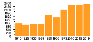
Population development
|
|
1 Including the Langendammsmoor incorporated in 1968 (= 128 inhabitants)
2 includingthe Langendammsmoor incorporated in 1968 (= 132 inhabitants) including
3 the Langendammsmoor incorporated in 1968 (= 131 inhabitants) including
4 the Langendammsmoor incorporated in 1968 (= 115 inhabitants) including
5 the Langendammsmoor incorporated in 1968 (= 211 inhabitants) including
6 includingLangendammsmoor incorporated in 1968 (= 152 inhabitants)
|
politics
City council and mayor
At the municipal level, the village of Stotel is represented by the Loxstedt municipal council.
Mayor
The mayor of Stotel is Fritz Grieger ( SPD ). The term of office runs from 2016 to 2021.
coat of arms
The Stotel municipal coat of arms was designed by the heraldist and coat of arms painter Albert de Badrihaye , who designed around 80 coats of arms in the Cuxhaven district.
|
|
Blazon : "In blue a silver spangenhelm with red and gold helmet covers and golden buffalo horns , crossed by two silver keys ." |
| Justification of the coat of arms: The coat of arms is modeled on the seal of the former Stotel office. The Spangenhelm with the buffalo horns contained the seal of the Counts of Stotel , the keys that of the Archbishops of Bremen . |
Culture and sights
Buildings
Monuments
- Stoteler Strasse, dating from the time of the Napoleonic War, is paved with field stones and is a cultural monument
- The Jewish cemetery is listed as a memorial and is located south of the Fredeholz
Economy and Infrastructure
Public institutions and companies
The public facilities include the Sternschnuppe kindergarten and the Waldmäuse integration kindergarten, the neighborhood club and the elementary school. In addition, the old school building is used by the local community.
There are also various clubs, doctors and businesses in the village. Company settlements are made possible in particular by the new “Loxpark” industrial park.
traffic
The A 27 motorway, completed in 1977, has an exit in Stotel. From there the federal highway 437 leads over the Weser tunnel into the Wesermarsch and to Friedeburg in the district of Wittmund . In the future, the planned coastal motorway A 22 will run near Stotel, and there are plans to expand the B 437 into a motorway. While the main variant does not leave the A 27 until Loxstedt, two of the secondary variants presented in the regional planning procedure run directly north and south of Stotel.
The village also had a stop on the Niederweserbahn, which opened in 1911 and closed on September 26, 1964 . Before that, it was also planned to relocate the route of the Geestebahn operated by the Royal Hanover State Railways on the shortest route between Bremen and Geestemünde . This would have led directly past the (former) Bundesstrasse 6 and Stotel. However, due to the political commitment in the Osterholz-Scharmbeck area and the then Loxstedter pastor , the railway was built near Loxstedt at the request of the state of Hanover . Local public transport is now operated exclusively with buses and call collective taxis within the Bremen-Lower Saxony transport association.
See also
- Unfinished structures
- There are also the following localities in the Osterholz district :
- Scharmbeckstotel (City of Osterholz-Scharmbeck )
- Lesumstotel (municipality of Ritterhude )
Personalities
Sons and daughters of the place
- Johann Böse (1739–1804), sugar manufacturer in Bremen
- Wilhelm Dieckmann (1893–1944), officer , archivist and resistance fighter against National Socialism
- Eilert Wilcks (* 1960), architect
People connected to the place
- Johann III. von Oldenburg (documented 1302–1342), Count of Oldenburg, he was the second son of Count Johann II from his first marriage to Elisabeth von Braunschweig-Lüneburg, around 1330 he temporarily took over the custodial rule in the County of Stotel
- Detward von der Hude (1345–1430), was a councilor of Bremen from 1375 and mayor of Bremen from 1417 to 1423, he owned forests in Stotel, among other estates
- Hinrich von der Hude (1390-1459), wholesale merchant, he came from the extensive family of ministers from the Hude from the Archdiocese of Bremen, except in the period of upheaval from 1427 to 1433, he also sat on the Bremen council from 1410 to 1459, he owned forests among other goods in Stotel
- Friedrich von Hessen-Eschwege (1617–1655), he was from 1632 until his death Landgrave of the Mediat Landgraviate Hessen-Eschwege, which was under the sovereignty of Hessen-Kassel, he received from the Swedish King a. a. the Stotel office
- Eleonore Katharine von Pfalz-Zweibrücken-Kleeburg (1626–1692), Countess Palatine von Zweibrücken-Kleeburg, Landgravine through marriage with Friedrich von Hessen-Eschwege, she inherited after the death of her husband a. a. the Stotel office
- Johann Balthasar Pott (1693 / 1694–1751), royal British and electoral Brunswick-Lüneburg bailiff in Hagen and Stotel
- Friedrich von Pufendorf († 1852), administrative lawyer, he entered the Hanoverian administrative service and in 1818 became an official assessor in Stotel
- Gustav Greiffenhagen (1902–1968), pastor in Bremen, who was relieved of his office during the National Socialist era. From 1929 to 1931 he was pastor in Stotel
literature
- Fritz Hörmann, Ude Meyer, Christian Morisse, Eberhard Nehring, Irmgard Seghorn, Egon Stuve, Else Syassen: Wesermünde field names collection - the field names of the property tax cadastre from 1876 . Ed .: Kulturstiftung der Kreissparkasse Wesermünde (= new series of special publications by the men from Morgenstern , Heimatbund an Elb- und Wesermuende eV Volume 27 ). Men from Morgenstern Verlag, Bremerhaven 1995, ISBN 3-931771-27-X , p. 20 ([ digitized version ( memento of October 26, 2007 in the Internet Archive )] [PDF; 431 kB ; accessed on October 23, 2019]).
- Heinrich Schriefer: Hagen and Stotel: History of the two houses and offices . Ed .: Culture and local history association of Hagen Castle. 3. Edition. Atelier in the Bauernhaus Verlag, Fischerhude 2011, ISBN 3-88132-149-7 .
-
Publications in the Niederdeutschen Heimatblatt
- Dieter Riemer : Gerbert von Stotel's “Proud in Break”. A ruling family and their castles in Stotel . In: Men from Morgenstern, Heimatbund an Elbe and Weser estuary e. V. (Ed.): Niederdeutsches Heimatblatt . No. 789 . Nordsee-Zeitung GmbH, Bremerhaven September 2015, p. 1 ( digital copy [PDF; 377 kB ; accessed on August 3, 2020]).
- Uwe Bargmann: Stotel - a place with a diverse history. Weser-Elbe-Heimattag 2019 at a place steeped in history . In: Men from Morgenstern, Heimatbund an Elbe and Weser estuary e. V. (Ed.): Niederdeutsches Heimatblatt . No. 833 . Nordsee-Zeitung GmbH, Bremerhaven May 2019, p. 1–2 ( digitized version [PDF; 3.2 MB ; accessed on June 14, 2019]).
- Andreas Hüser: Two castles in Stotel. An archaeological consideration . In: Men from Morgenstern, Heimatbund an Elbe and Weser estuary e. V. (Ed.): Niederdeutsches Heimatblatt . No. 833 . Nordsee-Zeitung GmbH, Bremerhaven May 2019, p. 2–4 ( digitized version [PDF; 3.2 MB ; accessed on June 14, 2019]).
Web links
Individual evidence
- ↑ a b Lower Saxony State Administration Office (ed.): Community directory for Lower Saxony . Municipalities and municipality-free areas. Self-published, Hanover January 1, 1973, p. 48 , Wesermünde district ( digitized [PDF; 21.3 MB ; accessed on June 3, 2020]).
- ↑ a b Population of the Loxstedt community. In: Website of the municipality of Loxstedt. June 30, 2019, accessed September 4, 2019 .
- ^ Federal Statistical Office (ed.): Historical municipality directory for the Federal Republic of Germany. Name, border and key number changes in municipalities, counties and administrative districts from May 27, 1970 to December 31, 1982 . W. Kohlhammer, Stuttgart / Mainz 1983, ISBN 3-17-003263-1 , p. 249 .
- ↑ Local home attendant. In: Website of the municipality of Loxstedt. Retrieved August 24, 2020 .
- ↑ Hinrich Lührssen : The great opportunity - a village high-rise has been empty for twelve years . In: The time . Issue No. 36/1985 . Zeitverlag Gerd Bucerius GmbH & Co. KG, August 30, 1985, ISSN 0044-2070 ( digital version [accessed on August 3, 2020] Can only be accessed with prior registration).
- ↑ Ulrich Schubert: Community directory Germany 1900 - Geestemünde district. Information from December 1, 1910. In: gemeindeververzeichnis.de. January 5, 2020, accessed August 3, 2020 .
- ^ Michael Rademacher: German administrative history from the unification of the empire in 1871 to the reunification in 1990. Wesermünde district. (See under: No. 51 and 82; online material for the dissertation, Osnabrück 2006).
- ↑ a b Statistisches Bundesamt Wiesbaden (ed.): Official municipality register for the Federal Republic of Germany - 1957 edition (population and territorial status September 25, 1956, for Saarland December 31, 1956) . W. Kohlhammer, Stuttgart 1958, p. 192 ( digitized version ).
- ↑ a b Statistisches Bundesamt Wiesbaden (ed.): Official municipality register for the Federal Republic of Germany - 1957 edition (population and territorial status September 25, 1956, for Saarland December 31, 1956) . W. Kohlhammer, Stuttgart 1958, p. 193 ( digitized version ).
- ↑ Population figures of the community of Loxstedt 2010–2013. (No longer available online.) In: Website of the Loxstedt community. December 31, 2013, archived from the original on March 8, 2014 ; accessed on August 3, 2020 .
- ↑ Population figures in the Loxstedt community 2014–2017. (No longer available online.) In: Website of the Loxstedt community. June 30, 2017, archived from the original on September 6, 2017 ; accessed on August 3, 2020 .
- ↑ Mayor of Stotel. In: Website of the municipality of Loxstedt. Retrieved April 13, 2019 .
- ↑ a b Landkreis Wesermünde (Ed.): Coat of arms of the Landkreis Wesermünde . Grassé Offset Verlag, Bremerhaven / Wesermünde 1973, ISBN 3-9800318-0-2 .
Bexhövede (with Nückel ) |
Büttel |
Thunder |
Düring |
Fleeste |
Hahnenknoop |
Hetthorn |
Holte |
Lanhausen | Loxstedt |
Nesse |
Neuenlande |
Schwegen |
Stinstedt |
Stotel
District Landwürden :
Buttel (Büttel) |
Dedesdorf-Eidewarden |
Maihausen |
Overwarfe |
Ueterlande |
Wiemsdorf