
Koenigsbach (Main)
|
Königsbach Luderbach, Erlenbach |
||
 The Königsbach in the Frankfurt city forest |
||
| Data | ||
| Water code | DE : 24798 | |
| location | Germany | |
| River system | Rhine | |
| Drain over | Main → Rhine → North Sea | |
| source | east of Dreieich near Haus Kirchborn 50 ° 0 ′ 43 ″ N , 8 ° 44 ′ 27 ″ E |
|
| Source height | approx. 157 m above sea level NHN | |
| muzzle | in Frankfurt-Niederrad at the southern foot of the Main-Neckar bridge in the Main Coordinates: 50 ° 5 ′ 42 ″ N , 8 ° 39 ′ 15 ″ E 50 ° 5 ′ 42 ″ N , 8 ° 39 ′ 15 ″ E |
|
| Mouth height | 95 m above sea level NHN | |
| Height difference | approx. 62 m | |
| Bottom slope | approx. 4.5 ‰ | |
| length | 13.7 km | |
| Catchment area | 27.69 km² | |
| Discharge A Eo : 27.69 km² at the mouth |
MNQ MQ Mq |
25 l / s 85 l / s 3.1 l / (s km²) |
| Right tributaries | Brook from the murder fountain, overflow of the Kesselbruchweiher | |
| Reservoirs flowed through | Jacobi pond | |
| Big cities | Frankfurt am Main | |
| Medium-sized cities | Dreieich , Neu-Isenburg | |
 The dry-fallen brook bed at the northern end of the Jacobi pond, just behind its weir |
||
The Königsbach (also Luderbach, Erlenbach; earlier also Frauenbach) is a flowing water in Hesse . It is an approximately 13.7 km long orographically left, geographically southern tributary of the Main . The source area of the brook is located near the city of Dreieich in the Offenbach district , the mouth is in the urban area of Frankfurt am Main . By damming the Königsbach in the Frankfurt city forest , the largest still water in Frankfurt, the Jacobiweiher , was created in the 1930s . From the headwaters to the Frankfurt city limits to the north of it, the stream bears the name Luderbach; the lower course of the water in the Frankfurt city area is officially called Königsbach .
Names
The brook was first mentioned in 1128 as "Kunigsbach". In the deed, the Roman-German King Lothar III. the Vogt Konrad von Hagen with seven mans of land between the south Main village of Schwanheim and the Königsbach. The name Königsbach refers to the Dreieich Wildbann , also known as the “Königswald” or “Königsforst” , the northern part of which the stream flows through. Other names with the same reference are Königsbrünnchen (previously Königsbrunnen, of which the stone frame with heraldic reliefs has been preserved), Königswiese and Königswiesenweg.
In the lower reaches of the stream was formerly called "Frauwenbach" (Frauenbach), the second oldest documented name of the water. A first reference to this section name is a document from 1193, when Emperor Heinrich VI. gave the “ Reichsgut am Frauenwege” ( Middle Latin: “allodium nostrum in Frowenwege” - literally: our Allod am Frauenweg) to the hospital in Sachsenhausen founded by the Teutonic Order . In 1338, Emperor Ludwig the Bavarian transferred goods from Niederrad to the "Frauenbach" to the Teutonic Order, who had owned extensive possessions in Sachsenhausen since the High Middle Ages .
Two feudal deeds from the 15th century attest that Königsbach and Frauenbach referred to the same stream. In 1417 King Sigismund gave the brothers Friedrich and Rudolf von Sachsenhausen as an imperial fiefdom "the Künigsbach, which forested through the empire bit on the Mayn, because it is the Frauwenbach, and the sea that they have there." King Friedrich III. enfeoffed in 1440 Wenzel von Cleen and his fellow heirs Wilhelm von Ingelheim with their imperial fiefs, including "the Königsbach flowing through the imperial forest to the Main, there called Frauenbach, including all lakes".
In Johann Hermann Dielhelm's work General Hydrographic Lexicon of all streams and rivers in Upper and Lower Germany from 1743, the body of water is listed under the name "Goldbach". This lexicon entry also mentions the names "Ludersbach" and "Frauenbach", and the course of the stream between Neu-Isenburg and Frankfurt is briefly described. In his essay Brief physical-geographical description of the area around Frankfurt , which appeared in the Archive for Frankfurt's History and Art in 1839 , Georg Ludwig Kriegk wrote that the brook in the forest is called "Luderbach" and in the field "Goldbach". There Luderbach and Königsbach are treated separately.
Different interpretations have been given for the term "Luderbach" used in current maps. Possibly the name comes from the word slut . According to another interpretation, "Lutterbach" comes from the term louder (for clear), which is also included in Hessian place names such as Lauterbach and Lauterborn .
In the city of Neu-Isenburg , a residential area around the brook and an immediately adjacent area designated as a fauna and flora habitat bear the name Erlenbachaue, even if this name has not otherwise been passed down for the brook.
The Forestry Office of the City of Frankfurt am Main gives priority to the oldest documented name Königsbach, and this name is also preferred in the publications published by the City of Frankfurt.
geography
General
The Königsbach / Luderbach ( river code number 24798) has an above-ground catchment area of 27.69 km². It is located in the Rhine-Main area north of the Rodgau . The stream drains over the Main and the Rhine to the North Sea . From a hydrological point of view , the Königsbach is one of the small low rivers in river and stream valleys . From the source to the mouth, the stream overcomes 62 meters in altitude, which corresponds to a mean bed gradient of 4.5 ‰ for a run length of 13.7 km. Within the populated areas along the course of the stream, residential and industrial buildings and other sealed areas predominate . Outside built-up areas, the area around the stream is characterized by floodplain landscapes with meadows and pastures.
The Königsbach has several natural retention areas along its course through undeveloped landscape . These include a floodplain in the district of Dreieich, two such areas on Neu-Isenburg, and one in the Sachsenhausen district of Frankfurt . At high water levels, the width of the areas flooded by the stream can vary between 10 m and a maximum of 250 m (found in Neu-Isenburg).
course
From Dreieich to Neu-Isenburg
There are divergent information about the exact location of the source of the Königs- / Luderbach in the literature, including current maps. The source area in question, which is cited consistently, lies between the towns of Dreieich in the west and Dietzenbach in the east, along the western boundary of which the Bieberbach , a tributary of the Rodau , runs further south-west on the Grüner Born .
According to the publications issued by the city of Frankfurt, the Königsbach rises at a height of about 157 meters above sea level northeast of Dreieich near Gut Neuhof and flows from there in a north-westerly to north-westerly direction. On the real estate map of the Hesse Geoportal, its source is in the Neuhofer Feld corridor a good half a kilometer west-southwest of Neuhof, and the UVF landscape plan also allows the Königsbach to rise near Neuhof.
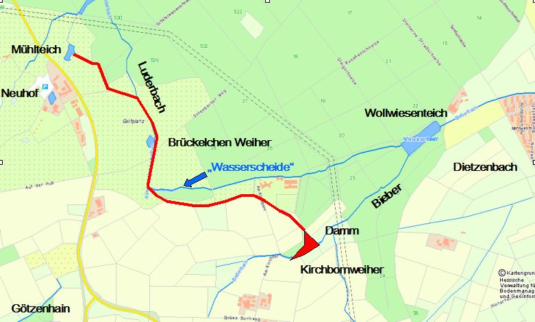
Several other publications, including historical maps, relocate the headwaters of the Königsbach about a kilometer further southeast, north of the Kir (s) chborn house between Götzenhain and Dietzenbach. According to this information, the Königsbach rises west of the Wollwiesenteich pond on the western outskirts of Dietzenbach, through which the Bieberbach flows in a south-west-north-east direction. The relevant stretch of water is referred to in parts of the literature as a “water connection” in a rift system and as a “ watershed ” (→ river bifurcation ) . A topographical map of the area around Frankfurt from 1865 also shows the source area of the stream in the area of Kirschbornweiher and Kirschborn-Wiese between Götzenhain and Dietzenbach without showing a single source that can be clearly identified. The WFD Viewer also shows a connection between the Luderbach and the left source brook of the Bieberbach.
The further course of the brook is shown uniformly in the literature from the Schweinhecke parcel northeast of Gut Neuhof . Starting at the Schweinhecke to the eastern outskirts of Neu-Isenburg, the course of the Königsbach lies continuously in nature reserves , including the Luderbachaue northeast of Dreieich. At Seibertswiese, a 1.8 km long stream flows to it from the right. There are both about one kilometer on either side of the river Barrow . The stream then describes a wide curve to the northwest and splits into two to three arms in the parcels of Bestewiese and Brandwiese (other sources also use the field names "Eckhardswiese" and "Müllerwiese"). Shortly before crossing under the Bundesautobahn 661 and Bundesstraße 46 , immediately north of the Neu-Isenburg junction, the Königsbach reaches the Neu-Isenburg urban area.
In Neu-Isenburg

The Königsbach flows through the district of Neu-Isenburg on its northeastern edge in a west and north-westerly direction. The brook has been partially straightened there and flows mainly in an approximately 100 meter wide floodplain landscape , the Erlenbachaue, which is protected as an FFH area . This field name and the nearby street Am Erlenbach are the only references to the name Erlenbach on the course of the stream itself and from literature and maps.
In the north of Neu-Isenburg, before the groundwater level fell , the Königsbach had carried enough water through construction work to drive a watermill , the Bansamühle built in 1705. The baroque house with the bansamühle has been preserved. The Neu-Isenburg street names An der Bansamühle and Am Mühlgraben, which have been used up to the present day in the immediate vicinity of the stream, provide information about the use of the Königsbach as a mill stream. There the stream flows through the Bansapark and its pond, which was created in the 20th century, and then crosses under Bansastraße and Gravenbruchring. Shortly before reaching the northern city limits of Neu-Isenburg, the Königsbach crosses the Huguenot and Waldensian trails.
In Frankfurt am Main


In the further course the Königsbach crosses the southeastern city limits of Frankfurt and flows over a distance of about 5.9 kilometers in the Frankfurt city area, of which about two and a half kilometers in the Frankfurt city forest . The Königsbach is next to the Kelster (also called Kelsterbach) and the 1.7 km long stream from the Mörderbrunnen one of three flowing waters in the area of the city forest. From the city limits, another part of the stream is straightened and he crossed just behind the highway A3 . Then the brook flows about 500 m parallel to the Darmstädter Landstrasse towards the north. Along this stretch, ditches that serve as overflows from the ponds Kesselbruchweiher , Försterwiesenweiher and Scherbelinoweiher, which were built in the extreme southeast of the city forest in the 20th century, flow into the stream from the right. After the Königsbach has been fed from the right side by the brook from the Mörderbrunnen, the brook bends to the northwest - in the main direction of flow, which it essentially maintains from there to the mouth. It flows through the Jacobi pond in the city forest, which was artificially created as a flood retention basin in the early 1930s. Before the damming, the stream often caused flooding in the residential areas on its lower reaches in Frankfurt-Sachsenhausen during heavy rains .
To the north-west of the Jacobi pond, the stream is again uneven, the stream meanders, and as the last inflow before the confluence from the right, the high sulfur and iron water of a stone spring called the Königsbrünnchen flows into it. In this section the brook crosses the lowlands of the Cleeisches Wäldchen (also called Königsbach-Aue), which forms the largest and most important area with alluvial forest and spring forest in the Frankfurt city forest. The alluvial forest is named after its owners in the 15th century, the noble von Cleen family, who had owned the village of Niederrad as a fief since 1426. In the forest clearing called Königswiese in the north , the stream is divided into an eastern, straightened, and a western, natural arm. The two arms of the stream unite again after a short stretch of river through the meadow and an allotment garden adjacent to the north. There the brook crosses under the route of the Mainbahn railway line and the southern section of Sachsenhäuser Strasse, the Ziegelhüttenweg.
The Königsbach flows between the Frankfurt districts of Sachsenhausen and Niederrad , whose shared district boundary it marks, through natural meadows and parks as well as through another allotment garden at the western foot of the Sachsenhausen Lerchesberg. After the road bridge of the Schwarzsteinkautweg (named after a former, neighboring basalt quarry kaute ) and the Frankfurt-Louisa train station , which is crossed by the stream in an east-west direction, to the mouth, the Königsbach runs largely parallel to the embankment of the Main- Neckar Railway . To the north of the station, it flows around the property of the Louisa forest play park on the east-northeast edge. On the grounds of the forest play park, the Königsbach forms an artificially created island through a pond-shaped left branch. Until 1941 it belonged to a piece of land laid out in 1812 by the Frankfurt banking family Bethmann as an English landscape garden on the initiative of Simon Moritz von Bethmann . Bethmann had named the park after his wife Louisa. The stream that connects to the north-west of the park in the direction of the Main has been straightened again from Mörfelder Landstrasse; this last part of the creek before the mouth often falls dry in the summer months. From Kennedy-Allee, the stream runs largely inaccessible on the clinic premises in a ditch behind the district heating pipes, parallel to the embankment of the Main-Neckar-Bahn.
In Frankfurt-Niederrad the Königsbach flows into the Main at a height of about 95 m above sea level below the Niederräder bank and directly at the foot of a southern pillar of the Main-Neckar Bridge . Until the last section of the stream was straightened, the estuary was about 500 meters further east across from Frankfurt's Westhafen on the site of what was then the “Blattern-Spital”, now the site of the Frankfurt University Hospital .
ecology
Water quality
According to the Water Framework Directive in Hesse, the overall ecological condition of the Königsbach is classified as moderate. The Environmental Atlas Hessen reviewed in 2010, the ecological status class of King Bach overall as "good". In the previous year, the degree of pollution of the stream with specific pollutants (organotin compounds, pesticides , polychlorinated biphenyls , heavy metals ) was also classified as “good”, the population of diatoms and macrozoobenthos was classified as “moderate”. Its pH fluctuates between 8.1 and 7.7. The fish population in the Königsbach was not assessed in the relevant studies. On the water quality map from 2015, the saprobic values of the stream in the area of the upper reaches are rated as "very good". In the area of the city of Frankfurt the rating deteriorates to “moderate” and in the area of the mouth the value then fluctuates between “good” and “very good”.
- Table with measurement parameters for chemical water quality from 2015
| date |
Ammonium -N [mg / l] |
Nitrate -N [mg / l] |
Nitrite -N [mg / l] |
Orthophosphate -P [mg / l] |
Oxygen [mg / l] |
|---|---|---|---|---|---|
| 01/22/2015 | 0.14 | 1.2 | 0.055 | 0.012 | 11.9 |
| 02/24/2015 | 0.12 | 1.1 | 0.068 | 0.0055 | 12.1 |
| 03/17/2015 | 0.12 | 0.2 | 0.039 | 0.0059 | 10.6 |
| 04/22/2015 | 0.07 | 0.23 | 0.147 | 0.005 | 10.4 |
| 05/13/2015 | 0.072 | 0.16 | 0.125 | 0.005 | 9.6 |
| 06/17/2015 | 0.07 | 0.17 | 0.031 | 0.005 | 9.6 |
| 07/01/2015 | 0.07 | 0.18 | 0.043 | 0.016 | 9.3 |
| 08/25/2015 | 0.07 | 0.17 | 0.028 | 0.005 | 9.7 |
| 09/15/2015 | 0.07 | 0.22 | 0.041 | 0.0083 | 9.6 |
| 14/10/2015 | 0.07 | 0.22 | 0.092 | 0.005 | 9.9 |
| 11/16/2015 | 0.07 | 0.16 | 0.035 | 0.005 | 9.2 |
| 12/09/2015 | 0.07 | 0.24 | 0.620 | 0.018 | 9.5 |
biosphere
fauna

A conspicuous bird species that occurs along the stream is the gray wagtail ( Motacilla cinerea ), a rarer relative of the white wagtail with a bright yellow underside. One of the particularly protected animal species on the Königsbach is the black-blue blue-blue ( Phengaris nausithous ). This butterfly species , which is on the Red List of Threatened Species , lives in the Erlenbachaue on the stream in the urban area of Neu-Isenburg, which is a protected landscape area and according to the Fauna-Flora-Habitat Directive (FFH) of the EEC as an FFH area. To the north of Neu-Isenburg you can see the fire salamander on Luderbach .
flora

One of the most conspicuous plants on the Königsbach is the spotted arum ( Arum maculatum ), which can be recognized by its bright red fruit cluster in early summer. Several tree species and some plants in the herbaceous layer are more typical of the vegetation along the stream. The rare alluvial forest of the Cleeisches Wäldchen as well as the one on the banks of the stream at the Louisa forest play park is mainly formed by the tree species black alder ( Alnus glutinosa ), flutter elm ( Ulmus laevis ), common ash ( Fraxinus excelsior ) and sycamore maple ( Acer pseudoplatanus ). Rare and protected plants can be found in the vegetation in the creek meadow of the Cleeischen wood. These include the marsh marigold ( Caltha palustris ), which has become rare in Frankfurt , the bitter foam herb ( Cardamine amara ), the alternate spleen herb ( Chrysosplenium alternifolium ), the musk herb ( Adoxa moschatellina ) and several types of sedges . A plant that occurs frequently in the Cleeic grove on the banks of the stream is wild garlic ( Allium ursinum ). The wet meadow-like part of the Königswiese on the natural western arm of the Königsbach is also overgrown with different types of sedges . Among them are the Carex Disticha ( Carex disticha ), the Carex vesicaria ( Carex vesicaria ) and Crepis paludosa ( Crepis paludosa ).
Leisure and Tourism
Along the almost 14 kilometers of the course of the brook there are some places that are of local or regional importance as excursion destinations for leisure activities. These include nature reserves, signposted local hiking trails, excursion restaurants, a forest play park and several objects of cultural and cultural-historical importance.
Hiking trails
Several forest trails and educational forest trails offer the opportunity for hikes on the Königsbach in the Frankfurt area, including the Weilruh nature trail, a circular hiking trail in the southeast of the Frankfurt city forest. In the city forest, the Königsbach is crossed several times by the forest aisles that are typical there; At the northwestern end of the Jacobi pond , at the green belt forest school, the green belt circular hiking trail crosses the creek on the Oberschweinstieg aisle.
Culture, gastronomy

In Neu-Isenburg, the historic manor house of the former Bansamühle with a baroque ornamental garden and the Bansapark to the south, through which a section of the Königsbach runs, are excursion destinations of local importance. There is a children's playground in the Bansapark.
Almost two kilometers down the stream, in the Frankfurt city forest (Sachsenhausen district) on the banks of the Jacobi pond, two sculptures by the draftsman and author F. K. Waechter line the pond created in the 1930s by damming the stream - the owl in a Norwegian sweater and the pee tree
Also on the banks of the Jacobi Pond, on the Oberschweinstiege, there is a seasonally open excursion restaurant with outdoor catering and parking spaces, which is much frequented in the warm season.
.JPG)
A sculpture of national importance can be seen a further two kilometers northeast along the course of the stream: The bronze sculpture Eclipse by the sculptor Christian Friedrich Tieck (1776–1851), exhibited in Park Louisa , owned by the Frankfurt banker and diplomat Simon Moritz von Bethmann (1768–1826) is an artist's impression of the British racehorse Eclipse . The listed sculpture stands - not directly accessible to the public - a few meters west of the Königsbach, which is artificially divided into two arms. There is also an adventure playground, the Louisa forest play park, on the area through which the stream flows.
The Königsbach flows at the foot of a monument on the Route der Industriekultur Rhein-Main Frankfurt am Main at the Main-Neckar Bridge, a railway bridge with a pedestrian walkway dating back to the late 19th century. At the southern foot of the bridge is the Niederrad light and air bath , which is adjacent to the mouth of the stream to the west and has a café with outdoor catering, playgrounds and a barbecue area. The area belonged to a river bath at the mouth of the Königsbach, established in 1900 on the headland of a needle weir of the Main from the 19th century.
See also
literature
- Gerd-Peter Kossler (ed.) And other authors: Forest in the south of Frankfurt: Stadtwald, Gravenbruch, Mönchbruch . Self-published, Frankfurt am Main 1991, ISBN 3-9800853-2-5 .
- Regionalpark Rhein-Main Südwest GmbH (Ed.): Leisure map south of the Main, part 3rd edition July 2013
- City of Frankfurt am Main, Green Space Office (ed.): StadtForst Frankfurt hiking map. 2009.
- City of Frankfurt am Main, Environment Agency (Ed.): The Green Belt Leisure Card. 7th edition. 2011.
- City of Frankfurt am Main, Environment Agency (Ed.): City waters - discover rivers, streams, oxbow lakes. Frankfurt 2004. Therein: Chapter Königsbach / Luderbach. P. 36 f.
Web links
- Königsbach / Luderbach at par.frankfurt.de , the former website of the city of Frankfurt am Main
- City of Frankfurt am Main, Environment Agency - Lower Water Authority (Ed.): Flood - what to do? Main (city center) and Luder- / Königsbach . Leaflet with a detailed representation of the course of the brook in Frankfurt as well as marked flood-endangered areas in the Frankfurt district (PDF file, 1.5 Mb, accessed on Feb. 25, 2020)
- Hessian State Office for Environment and Geology: Retention cadastre, Luderbach river area - River area code number: 24798 (PDF; 111 KB) ( Notes ),
- Profile Luderbach ( Memento from August 9, 2014 in the web archive archive.today )
- Hessian Land Surveying Office, sheet 5918: Neu-Isenburg, status: 1949 . Topographic map on a scale of 1: 25,000 with drawn, color-highlighted course of the Königs- / Luderbach from the headwaters to Frankfurt-Louisa. Edited version of the U.S. Army Map Service, AMS Series M841, Washington, D. C. 1952. High-resolution digitized copy of the BYU Harold B. Lee Library Digital Collections (Download: 16.3 Mb, accessed July 2, 2015)
- Map of the city and district of Frankfurt , topographic map on a scale of 1: 50,000, published by L. Ravenstein's Geological Institute in Frankfurt a. M.
- Map of the Grand Duchy of Hesse, Darmstadt 1823–1850 (scale 1: 50,000) .
- Map of the area around Frankfurt, Darmstadt approx. 1865 (scale 1: 25,000)
- Source and upper course: [area around Frankfurt] approx. 1865 [Rödelheim sheet after 1865] - 4. Neu-Isenburg. Historical maps. In: Landesgeschichtliches Informationssystem Hessen (LAGIS).
- Estuary: [area around Frankfurt] approx. 1865 [Rödelheim sheet after 1865] - 3. Kelsterbach. Historical maps. In: Landesgeschichtliches Informationssystem Hessen (LAGIS).
Individual evidence
- ↑ a b Water map service of the Hessian Ministry for the Environment, Climate Protection, Agriculture and Consumer Protection ( information )
- ↑ a b c d HGN, Hydrogeologie GmbH Nordhausen: Retention register of the Luderbach river area, October 2004. (PDF; 111 kB, accessed on July 1, 2015)
- ↑ Luderbach profile ( memento from August 9, 2014 in the web archive archive.today )
- ^ Hermann Mayenschein, Michael Uhlig: Between Sandhof and Mainfeld. Past and present of the former village and today's district of Niederrad, p. 14. Published by Frankfurter Sparkasse from 1822 (Polytechnische Gesellschaft), Frankfurt am Main 1987.
- ^ Regesta Imperii Online: RI IV, 1.1 n.178 , accessed on September 21, 2017
- ^ A b City of Frankfurt am Main, Forest Office (ed.): From Altheeg to Vierherrnstein - names in the Frankfurt city forest . Schutzgemeinschaft Deutscher Wald, Kreisverband Frankfurt eV, 1988, p. 70.
- ↑ Hans Pehl: When they once protected the city - Frankfurt's fortified manors . In it: Chapter The Sandhof - a religious house with entertainment. Verlag Josef Knecht, Frankfurt am Main 1978, ISBN 3-7820-0411-6 , p. 56 ff.
- ^ Regesta Imperii Online: RI VII H. 8 n. 401 , accessed on September 21, 2017
- ↑ Quoted from: Johann Heinrich Tabor: Defended Kayserliche Eigenhum , ohne Ort, 1775, p. 81 ff. Online
- ^ Regesta Imperii Online: RI XI, 1 n.2376 , accessed September 21, 2017
- ^ Regesta Imperii Online: RI XIII H. 8 n.1 , accessed on September 21, 2017
- ↑ General Hydrographic Lexicon of all streams and rivers in Upper and Lower Germany
- ^ Georg Ludwig Kriegk : Brief physical-geographical description of the area around Frankfurt . In: Archive for Frankfurt's History and Art . tape 1 , 1839, p. 1–117, here p. 43 ( full text in the Google book search).
- ↑ a b c Regional Park Rhein-Main Südwest GmbH (Ed.): Leisure map south of the Main, part 3, edition July 2013.
- ^ Friedrich Scharff: The streets of the Frankenfurt . In: Archive for Frankfurt's History and Art. New episode . tape 3 , 1865, p. 205–254, here p. 251 ( full text in the Google book search).
- ↑ a b c d e City waters - discovering rivers, streams, oxbow lakes, p. 36 f .: Chapter Königsbach / Luderbach
- ↑ Photo of an information board for the Oberforsthaus circular hiking trail in Frankfurt on Wikimedia Commons
- ↑ Information board of the city of Neu-Isenburg in the FFH area Erlenbachaue (photo on Wikimedia Commons)
- ^ City of Frankfurt am Main, Forestry Office (ed.): From Altheeg to Vierherrnstein - names in the Frankfurt city forest . Schutzgemeinschaft Deutscher Wald, Kreisverband Frankfurt eV, 1988, supplement: City forest map
- ↑ Type 19: Small low rivers in river and stream valleys (PDF file)
- ↑ a b City of Frankfurt am Main, Environment Agency, project group GrünGürtel (Ed.): Leaflet Rundweg im Grüngürtel Park Oberforsthaus . 1st edition. 2009.
- ↑ Soil slope , Spektrum.de
- ↑ a b Regionalpark Rhein-Main Südwest GmbH (Ed.): Leisure map south of the Main, part 2, July 2013.
- ↑ a b c Königsbach / Luderbach at par.frankfurt.de , the former website of the city of Frankfurt am Main
- ^ Landscape plan UVF , Umlandverband Frankfurt, December 2000
- ↑ The headwaters of Königsbach and Bieber on steine-in-der-dreieich.de . Site plan based on a map, published by the Hessian Administration for Land Management and Geoinformation (accessed on July 2, 2015)
- ↑ Wilhelm Ott: Isenburger Oberwald, chapter ditch system between Kirchborn and Neuhof on steine-in-der-dreieich.de (accessed on July 2, 2015)
- ↑ Around Frankfurt approx. 1865; Sheet Rödelheim after 1865 - 4. Neu-Isenburg 1: 25,000. Historical maps. In: Landesgeschichtliches Informationssystem Hessen (LAGIS).
- ↑ Headwaters of the Königs- / Luderbach on the WFD Viewer
- ↑ Die Luderbachaue von Dreieich ( Memento of the original dated May 30, 2016 in the Internet Archive ) Info: The archive link was inserted automatically and has not yet been checked. Please check the original and archive link according to the instructions and then remove this notice. on Kreis-offenbach.de (accessed on May 30, 2016)
- ↑ WFD Viewer
- ↑ City of Frankfurt am Main, Grünflächenamt (Ed.): StadtForst Frankfurt hiking map, 2009.
- ↑ The current maps of different publishers also differ considerably in the field names of the area.
- ↑ Photo of an information board at the Bansamühle on Wikimedia Commons (accessed August 21, 2012)
- ↑ a b Kossler: Forest in the south of Frankfurt: Stadtwald, Gravenbruch, Mönchbruch, p. 16 ff.
- ↑ Falk map of Frankfurt am Main, 57th edition. Falk publishing house, Ostfildern
- ↑ a b c d e f g h Environment Office of the City of Frankfurt am Main (ed.): The GrünGürtel Freizeitkarte, 7th edition. 2011.
- ↑ Kleine Senckenberg series 50: Nature on the doorstep - urban nature in Frankfurt am Main (various authors), p. 88 E. Schweizerbart'sche Verlagbuchhandlung (Nägele and Obermiller), Stuttgart 2009, ISBN 978-3-510-61393- 9 .
- ↑ a b Kleine Senckenberg series 50: Nature on the doorstep - Stadtnatur in Frankfurt am Main (various authors), p. 127 ff. E. Schweizerbart'sche Verlagbuchhandlung (Nägele and Obermiller), Stuttgart 2009, ISBN 978-3- 510-61393-9 .
- ↑ a b Kleine Senckenberg series 50: Nature on the doorstep - Stadtnatur in Frankfurt am Main (various authors), p. 112. E. Schweizerbart'sche Verlagbuchhandlung (Nägele and Obermiller), Stuttgart 2009, ISBN 978-3-510 -61393-9 .
- ^ City of Frankfurt am Main, Forestry Office (ed.): From Altheeg to Vierherrnstein - names in the Frankfurt city forest . Schutzgemeinschaft Deutscher Wald, Kreisverband Frankfurt eV, 1988, p. 51.
- ^ Hermann Mayenschein, Michael Uhlig: Between Sandhof and Mainfeld. Past and present of the former village and today's district of Niederrad, p. 16.
- ↑ on frankfurt.de accessed on Feb. 25, 2020
- ↑ City map from 1885 (detail) of the Frankfurt Ravenstein Publishing House on Wikimedia Commons.
- ^ Niederrad map from 1879. In: Hermann Mayenschein, Michael Uhlig - Between Sandhof and Mainfeld. History and present of the former village and today's district of Niederrad, p. 11. Frankfurter Sparkasse von 1822 (Ed.), 3rd edition 1987.
- ↑ Water Framework Directive in Hesse, water body: Luderbach ( Memento from August 9, 2014 in the web archive archive.today ) (Status: November 19, 2009, accessed on March 9, 2012)
- ↑ Environmental Atlas Hessen: Ecological status class . Water body map of the state with assessments , status 2010 (PDF file, 868 KB, accessed on February 6, 2016)
- ↑ a b State-wide measurements: Luderbach, Frankfurt , Hessian State Office for Nature Conservation, Environment and Geology (HLNUG)
- ↑ Environmental Atlas Hessen: Water Framework Directive. Ecological status of the water bodies, status 2009 . River map of the state with ratings (PDF file, 2.8 MB. Accessed February 6, 2016)
- ↑ Ecological status - assessment of the water quality part saprobic , December 31, 2015, Hessian State Office for Nature Conservation, Environment and Geology (HLNUG)
- ↑ Chemical water quality classification according to LAWA
- ^ Ortho-phosphate
- ↑ Information boards of the city of Neu-Isenburg on the edge of the FFH area Erlenbachaue
- ↑ Fire salamander in the Frankfurt city forest, am Luderbach , Hessian Ministry for the Environment, Climate Protection, Agriculture
- ^ Monika Peukert: Botanical sketches in the Oberwald. In: Gerd-Peter Kossler (Ed.): Forest in the south of Frankfurt: Stadtwald, Gravenbruch, Mönchbruch, p. 19.
- ↑ Owl in a Norwegian sweater , a sculpture designed by FK Waechter at the Jacobiweiher at kunst-im-oefflichen-raum-frankfurt.de (accessed on February 9, 2016)
- ↑ Pinkel tree, designed by FK Waechter sculpture at Jacobi pond on kunst-im-oeffentlichen-raum-frankfurt.de (accessed on 9 February 2016)
- ^ Website of the restaurant Oberschweinstiege (accessed on February 9, 2016)
- ↑ State Office for the Preservation of Monuments in Hesse (ed.): Horse statue and stele in the Louisapark In: DenkXweb, online edition of cultural monuments in Hesse
- ↑ Official website of the Niederrad light and air bath at lilu-frankfurt.de (accessed on February 9, 2016)
- ↑ Article about the Alte Schleuse Niederrad on naturship.de (accessed on February 10, 2016)